Description
Welcome to the GSS' Tongass Fjords project
The package has its spiritual roots at the legendary Tongass Fjords X (TFX) addon package. My releases currently consist of
- this CBW4 package
- Galore Valley airstrip, Galore Creek
- Cirque airstrip, Galore Creek
- Bronson Creek airstrip
- Johnny Mountain airstrip
FEATURES
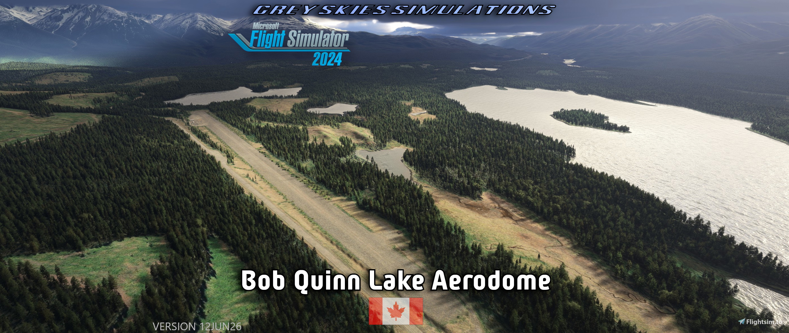
- Runway is sided with ditches, drop-offs, mounds and other dangerous countours.
- Elevation 1,952 feet, gravel runway 4,251 x 128 feet (1296 x 38 meters)
- 2 helicopter starting locations, on wooden pad and gravel
pad is the Northern one
- water starting location on the Lake
- This is some sort of base for supporting mining operations in real life.
- Located in Kitimat-Stikine district, British Columbia, Canada. Water features close by are the Iskut and Ningunsaw rivers and the namesake lake.
- Designed to work with my Galore Creek airstrip sceneries (XGS02+XGS03), which are about 41NM to North West as the swan flies.
- Low & High altitude Flight Plans are included
- Custom aerial image and models.
- Moose are known to wander around in the area.
- Landmark POIs.
- Easter eggs.
- Readme.
NOTES
- Designed to be used with Bijan Seasons Enhanced 2024 (payware) and default Bing aerials.
Warning: If you don’t have BSE installed, you won’t have the intended experience. However:
- A crude version is available with the v1.1 release, to be used with non-Bijan vegetation. There may be side-effects.
- Flight Plans were made with Little Navmap & it’s offline elevation model.
First has a more wandering route along valleys and rivers, altitude ~6500.
- Latter is more direct, altitude ~8000.
- Sim’s helicopter starting locations’ numbers ordering’s logic is beyond me.
- Default aerial images have room for improment to put it nicely. I made a custom ZL20 aerial image for airport area, which works in FS20. A bug exists in FS24, where the terrain clips though the background image (SU3 1.5.27 SDK 1.4.5). Flightsim.to limits my upload size to 100 MB, so I’ve had to limit the resolution and coverage area.
Color Matching was done in FS20, differences are likely is FS24.
- In this project I’ve increased my own model production.
- FS24 light source editing/exporting in Blender is bugged and they don’t show up as designed.
- Designed mainly in FS20. Twiddling has been done in MSFS 2024, let me know if you spot bugs.
- Aerodome’s and highways elevation differences are larger IRL, but I couldn’t get my mesh tools to work.
- If AI traffic spawns at parking locations, lower their density as desired.
- Close together objects may clip some times, because they don’t spawn exactly as set in editor.
- FS24 polygons arent exact between editor & sim, so overlap may occur.
- Supplied details regarding the area may lead to updates.
- In case of discrepancies regarding this document, this site is the primary source.
INSTALLATION INSTRUCTIONS
- check download location for latest recommended prerequisites and instructions
- (always remove old scenery packages from the Community-folder, if installed previously)
- move greyskies-airport-cbw4-bob-quinn-lake into the Community-folder
- check that greyskies-modellib-gss-common-library-msfs2020/2024 is in the Community-folder as well
Grey Skies Simulations' Common Library version 12JUN26 or newer is required.
- MSFS Addons Linker / ModManFX are recommended in general for managing your mods
RECOMMENDED LIBRARIES FOR DESIGNED FIDELITY (as published on 29AUG25)
- Standard MSFS content from Microsoft&Asobo.
Following packages from World updates (FS20):
- 40th Anniversary POI
- Grey Skies Simulation’s Common Model Library
- UK2000 Common Library (MS Marketplace)
- as listed in Dependencies section on the bottom of the page
MY OTHER UPLOADS
https://flightsim.to/profile/GreySkies/uploads
LIVE-STREAMING
I do stream sometimes.
latest revision 12JUN26
Dependencies
Bob Quinn Lake Aerodome (CBW4), British Columbia BC, Canada
Bob Quinn Lake Aerodome (CBW4) is a detailed scenery add-on for Microsoft Flight Simulator, located in British Columbia, Canada, within the Kitimat-Stikine district. It features a gravel runway measuring 4,251 feet, including challenges such as ditches and mounds. The package coordinates with additional airstrips in the Galore Creek area and includes custom aerial images, flight plans, and helicopter starting locations. Designed primarily for use in FS20 and updated for MSFS 2024, it adds realism to aviation operations in the region.

User Reviews
2 reviews
Location
More Information
Version History
- Runway designations & elevations changed to comply with current publications. Runway is designated 33/15 and is officially 55 meters shorter. - Adjusted vegetation to Bijan Seasons Enhanced. A crude version with normal trees is supplied as alternate package with the 1.1 update. - Added snow banks during December to March. - Increased amount of details. - Redone terraforming to resemble more real. Default mesh for this area is poor. - Updated models. - Replaced windsocks. - Tuned object placement. - Shifted parking locations. - Added helicopter C&D parking.
Related
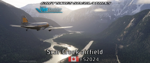
Scar Creek Airfield, British Columbia BC, Canada (CBA7) + Plummer Hut
Discover a hidden gem in Microsoft Flight Simulator 2020/2024—an off-grid airstrip set deep in British Columbia's glacier territory. Featuring a 3,000 ft sand runway, a 46° STOL slope, helicopter and water start points, a mystery strip, and even moose sightings, this location offers rugged adventure. Explore handcrafted terrain near Homathko Glacier, with bush-flying challenges and stunning scenery for pilots who dare to land where few have.
by Grey Skies Simulations
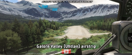
Galore Valley (Uhtlan) Airstrip, Galore Creek, British Columbia BC, Canada
The Galore Valley (Uhtlan) Airstrip add-on introduces a handcrafted, challenging airstrip located in Galore Creek, British Columbia. Featuring a sloped gravel runway and limited go-around options, this add-on includes three helicopter starting locations and custom aerial imagery. The airstrip serves as an aviation support hub for local mining operations and is designed to complement the nearby Bob Quinn Lake aerodome (CBW4).
by Grey Skies Simulations
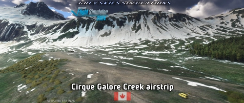
Cirque Airstrip, Galore Creek, British Columbia BC, Canada
Discover the Cirque Airstrip located in Galore Creek, British Columbia, part of the GSS Tongass Fjords project. This handcrafted airstrip features a challenging sloped runway and is surrounded by rugged terrain, making it ideal for adventurous exploration. The package includes custom aerial imagery and models, and is designed for use with the nearby Bob Quinn Lake aerodome. Elevation at the airstrip is 2,962 feet, with a gravel runway measuring 1,732 x 121 feet.
by Grey Skies Simulations
4D2 - Hoodoo Meadows airstrip, Idaho, USA
Hoodoo Meadows airstrip (4D2) is located in Idaho and is noted as the states highest official backcountry airport with an elevation of 8,262 feet. The airstrip features a sloped, uneven gravel and dirt runway measuring 1,900 x 50 feet, and includes distinct markings and natural obstacles. Additional facilities include helicopter starting locations and a water launch site at Yellowjacket Lake, alongside custom models and landmark points of interest in a scenic mountainous area.
by Grey Skies Simulations
5 months ago