Description
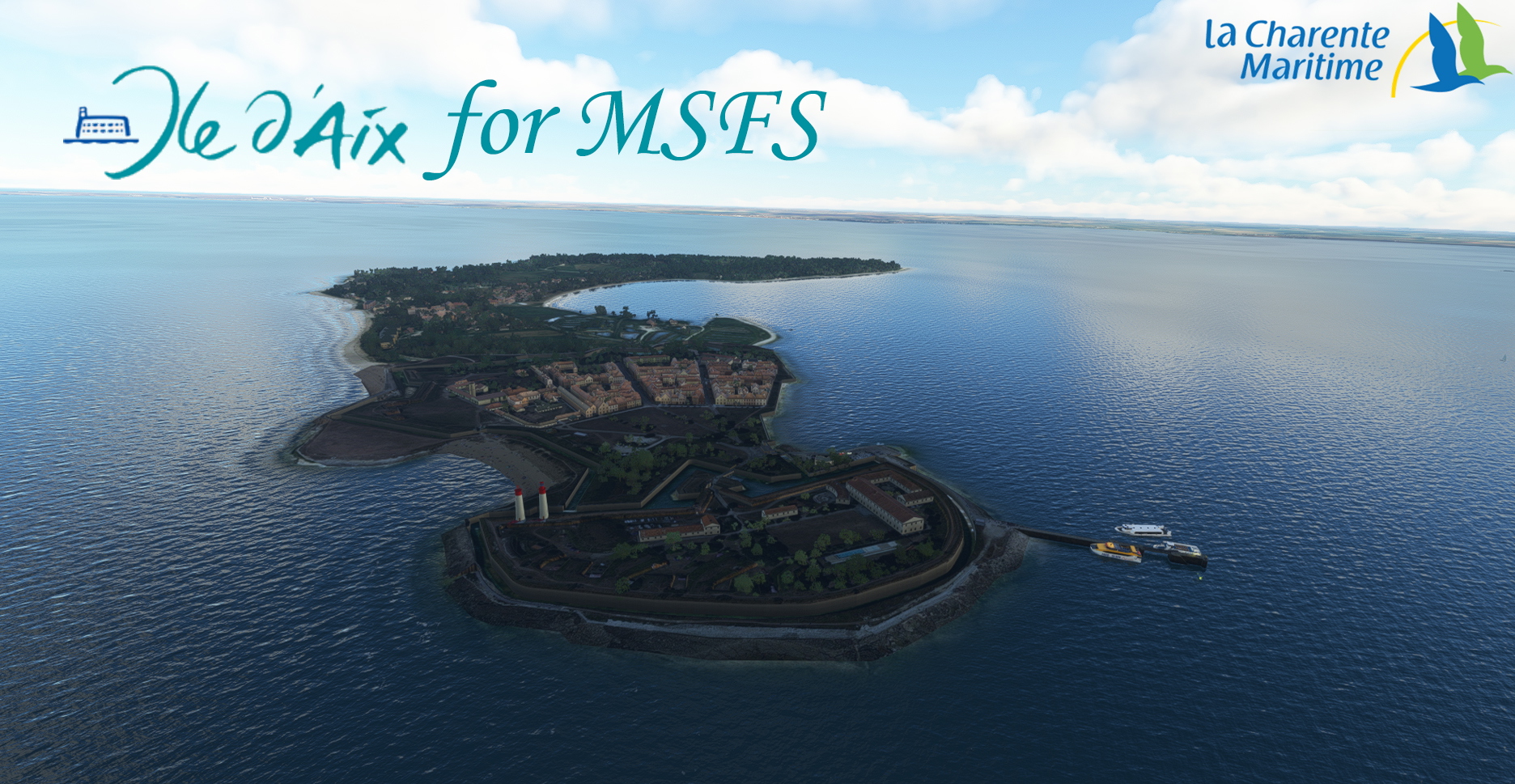
The island of Aix is located to the west off the tip of La Fumée, which is the end of the Fouras peninsula, and to the east of the island of Oléron. It was used as a defensive element of the Rochefort arsenal during the Napoleonic era.
Nowadays it is best known for its citadel and its twin lighthouses.
The scene includes:
- the entire Fort de la Rade citadel
- the Lighthouses made and kindly made available by Droide, again a huge thank you to him!!!
- the old semaphore of the island
- the old powder magazine
- the church of "Saint Martin of Aix"
- Fort Liedot
- the two squares which mark out the littoral of the island.
Good visit and good flight to all!
L'île d'Aix est située à l'ouest au large de la pointe de la Fumée, qui est l'extrémité de la presqu'île de Fouras, et à l'est de l'île d'Oléron. Elle fut utilisée comme un élément défensif de l'arsenal de rochefort sous l'ère Napoléonienne.
De nos jours elle est surtout connue pour sa citadelle et ses phares jumeaux.
La scène comprend:
- l'enssemble de la citadelle du Fort de la Rade
- les phares réalisés et aimablement mis a disposition par Droide, encore un immense merci à lui
- l'ancien sémaphore de l'ile
- l'ancienne poudrière
- l'église de "Saint Martin d'Aix"
- le Fort Liédot
- les deux carrelets qui jalonne le littoral de l'ile.
Bonne visite et bon vol à tous!
Dependencies
Comments(20)
Log in to join the discussion
Log In2 months ago
Bonne journée.
almost 2 years ago
Les maisons sont en forme de boîtes à chaussures. Que de l'autogen!
Seuls les deux phare sont bien représentés (1.37.19).
almost 2 years ago
Oui c'est l'autogen de base sur l'ile sauf la citadelle.
Quel est votre soucis du coup?
over 2 years ago
over 3 years ago
Beau travail. Faut juste que je trouve l'origine de mon doublon des deux phares (quatre en tout)
over 3 years ago
Le doublon du phare d'Aix est avec francevfr-landmarks-vfr-france
[img]https://i.imgur.com/uJdy1iZ.jpg[/img]
Y aurait-il possibilité de faire un exclude pour masquer ceux de France VFR?
over 3 years ago
Bonjour, l'exclude est déjà présent. FranceVFR n'ayant toujours pas compris comment fonctionne la hiérarchisation des scènes, je ne suis pas responsable de cela.
Pour que cela fonctionne vous devez renommer leur scène obstacle avec un chiffraison inférieur à la mienne. Cela devrais donner quelques chose comme France-0-Obsctacle etc etc.
Bon vol!
over 3 years ago
Merci. J'ai effectivement pensé à la hierarchisation des scenes pendant mon sommeil!!
Maintenant c'est tout bon.
over 3 years ago
Super si cela fonctionne profitez-en bien!!!!
over 3 years ago
Wow ! Superbe travail !
over 3 years ago
Merci beaucoup!!! Amusez vous bien dans la région!
Ile d'Aix
Explore the historic island of Aix in Microsoft Flight Simulator, featuring the iconic Fort de la Rade citadel, twin lighthouses, old semaphore, church of Saint Martin, and more. Immerse yourself in the Napoleonic era defense structures and picturesque coastal landmarks for a truly authentic flying experience.

User Reviews
6 reviews
Location
More Information
Version History
Add "Fort Lapointe"
Related

Swiss mountains tree fix (trees on mountains removed)
A comprehensive mod fixing tree placement on Swiss mountains, particularly removing inaccurately placed trees on mountain peaks. The update includes a shift to more realistic conifer trees in the Alps and an expansion to border areas of France, Italy, and Austria. From Alpstein Säntis to Stockhorn, numerous locations across Switzerland have been meticulously corrected for a more authentic flight experience.
by THEOLI4D

Shorter Trees / Tree Height Modification VERSION 4.0 for MFS2020 (shorter, realistic trees)
Experience realistic and shorter trees in Microsoft Flight Simulator with the Shorter Trees / Tree Height Modification VERSION 4.0 add-on. Compatible with the latest version of MSFS, this mod provides adjusted tree heights for a more authentic flying experience. Update includes enhanced tree coloration blending seamlessly with photogrammetry trees. Installation is simple - just copy the folder into your community folder and enjoy a new perspective from the skies.
by ARIF STUDIOS - Adnan Arif

AUSTRIA 10m DEM - High Resolution Terrain Elevation Data from LIDAR Imaging
Explore the stunning terrain of Austria with this mod featuring high-resolution LIDAR data, offering a mesh resolution of 10m for a more realistic flight experience. Flatten lakes, rivers, and eliminate any terrain artifacts as you soar over the Austrian landscape. Divided into regions for convenience and performance optimization, this mod enhances the mountain shapes to mirror reality and provides a smoother flying experience. Experience Austria like never before with enhanced elevation data and realistic terrains.
by Troglodytus

SWITZERLAND 20m DEM - High Resolution Terrain Elevation Data from LIDAR Imaging
Explore the beauty of Switzerland with this mod offering high resolution terrain elevation data using LIDAR imaging. The mesh resolution is 20m, providing exceptional detail with a height resolution of 0.1m. Update includes extreme LIDAR meshes for specific regions. Please note potential performance impacts and report any bugs for further improvements. Fly VFR over Switzerland with enhanced realism and accuracy.
by Troglodytus
2 months ago
Merci