Description
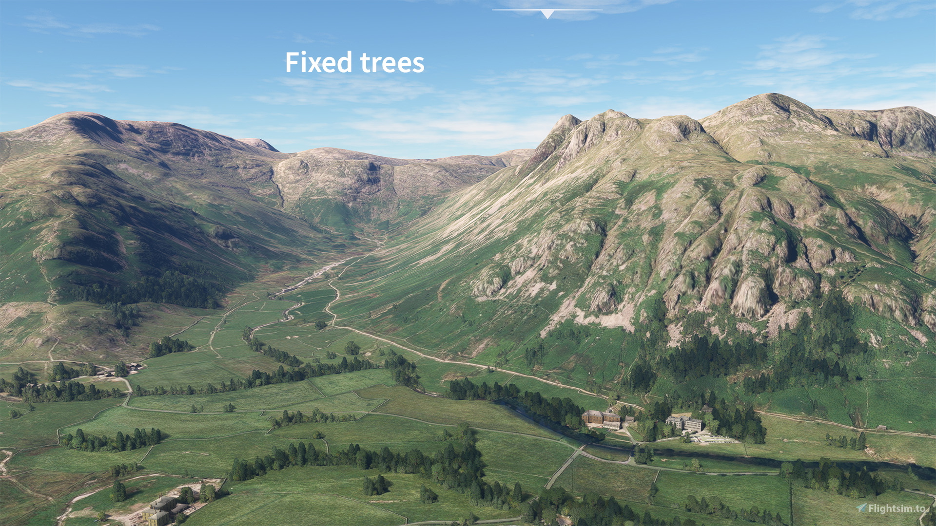
This add-on aims to correct the autogen trees in the Lake District national park. The AI autogen has misinterpreted all kinds of rocky crags, shadows and patches of heather/bush as full sized trees, leading to a rather unrealistic amount of tree vegetation up on the high ground of The Lakes. There are also a few rogue autogen buildings where there shouldn't be. I've been round and cleaned this up, the bulk of the tree removal is complete but I'll refine it over time if there are any missed patches. Let me know in the comments if you find big clusters of trees where they shouldn't be, or any patches where I've been over-zealous with my deforestation. This has not been tested with the 3rd-party Orbx British Isles Mesh terrain since I don't own it.
I've attached a map showing the areas I've covered. This is most of the high ground where there were excessive trees.
This may also expand to include more minor scenery fixes in the Lake District. So far it includes:
- Removal of excessively tall wind turbines at Kirkstone Pass Inn. The real turbines there are very small, it looks better not to include any.
- Parked cars at Kirkstone Pass Inn.
- Churches (generic Asobo model) in Keswick and Ambleside
- Boats, piers and pontoons around Windermere (work-in-progress). This is fully compatible with the excellent Mamudesign Marinas scenery, my hand-placed boats and piers will take priority over the Mamudesign ones, wherever there is any overlap.
Drop any other suggestions in the comments and I'll consider them!
Always remove the previous version of the add-in before adding a new version to your Community Folder
Want more UK tree fixes? Check out:
Peak District National Park by me
Dartmoor National Park by me
Yorkshire Moors and Dales by craigr
Snowdonia by bujin1977
Dependencies
Comments(35)
Log in to join the discussion
Log In4 months ago
over 2 years ago
over 2 years ago
over 2 years ago
over 2 years ago
over 2 years ago
over 2 years ago
over 2 years ago
Not sure if this in included in your area but I noticed there should be trees at 54° 31.50' N 2° 48.32' W
over 2 years ago
EDIT: fixed in v0.4
over 2 years ago
about 3 years ago
Great work! Any chance you can add some of the north pennies in? Near Dufton to sort out High cup nick and the Cross Fell area out? It's covered with trees/bushes needs clearing up.
over 2 years ago
over 3 years ago
Fantastic work, really makes a big difference when flying in the area. Would love to see the Mach Loop (Wales/Snowdonia area etc) given some love if you are continuing the project!
over 3 years ago
Thanks! I've seen a few requests for the Mach Loop. I'm haven't yet checked a map to see what the extent of the Mach Loop is, but does this Snowdonia add-on cover it? https://flightsim.to/file/4221/snowdonia-deforestation
Or does the Mach Loop extend outside that area?
about 3 years ago
It extends outside of the area from what I can see. There's plenty of maps online showing the area of where aircraft Loop around. If you need a helping hand just send me a message and i'll be more than happy to help if you ever plan on taking up this project. It would be great to see it cleaned up and looking spiffy for flights! Thanks in advance :)
over 3 years ago
Verified with SU12
Lake District National Park scenery corrections (tree fix & more)
Enhance the realism of the Lake District National Park in Microsoft Flight Simulator with this add-on focusing on correcting autogen trees and other scenery inaccuracies. From removing excessive trees on high ground to fixing misplaced buildings and adding detailed elements like boats and piers around Windermere, this mod aims to provide a more accurate representation of the iconic park. Explore the beautiful British landscape with improved visuals and minor scenery fixes.
User Reviews
4 reviews
Location
More Information
Version History
Eliminated conflicts with Mamudesign Marinas scenery by adding exclusion rectangles on my hand-placed boats and marinas where there is an overlap.
Related

Swiss mountains tree fix (trees on mountains removed)
A comprehensive mod fixing tree placement on Swiss mountains, particularly removing inaccurately placed trees on mountain peaks. The update includes a shift to more realistic conifer trees in the Alps and an expansion to border areas of France, Italy, and Austria. From Alpstein Säntis to Stockhorn, numerous locations across Switzerland have been meticulously corrected for a more authentic flight experience.
by THEOLI4D

Shorter Trees / Tree Height Modification VERSION 4.0 for MFS2020 (shorter, realistic trees)
Experience realistic and shorter trees in Microsoft Flight Simulator with the Shorter Trees / Tree Height Modification VERSION 4.0 add-on. Compatible with the latest version of MSFS, this mod provides adjusted tree heights for a more authentic flying experience. Update includes enhanced tree coloration blending seamlessly with photogrammetry trees. Installation is simple - just copy the folder into your community folder and enjoy a new perspective from the skies.
by ARIF STUDIOS - Adnan Arif

AUSTRIA 10m DEM - High Resolution Terrain Elevation Data from LIDAR Imaging
Explore the stunning terrain of Austria with this mod featuring high-resolution LIDAR data, offering a mesh resolution of 10m for a more realistic flight experience. Flatten lakes, rivers, and eliminate any terrain artifacts as you soar over the Austrian landscape. Divided into regions for convenience and performance optimization, this mod enhances the mountain shapes to mirror reality and provides a smoother flying experience. Experience Austria like never before with enhanced elevation data and realistic terrains.
by Troglodytus

SWITZERLAND 20m DEM - High Resolution Terrain Elevation Data from LIDAR Imaging
Explore the beauty of Switzerland with this mod offering high resolution terrain elevation data using LIDAR imaging. The mesh resolution is 20m, providing exceptional detail with a height resolution of 0.1m. Update includes extreme LIDAR meshes for specific regions. Please note potential performance impacts and report any bugs for further improvements. Fly VFR over Switzerland with enhanced realism and accuracy.
by Troglodytus
4 months ago