Description
French Alps - Department of Haute-Savoie (74) 1.0.0
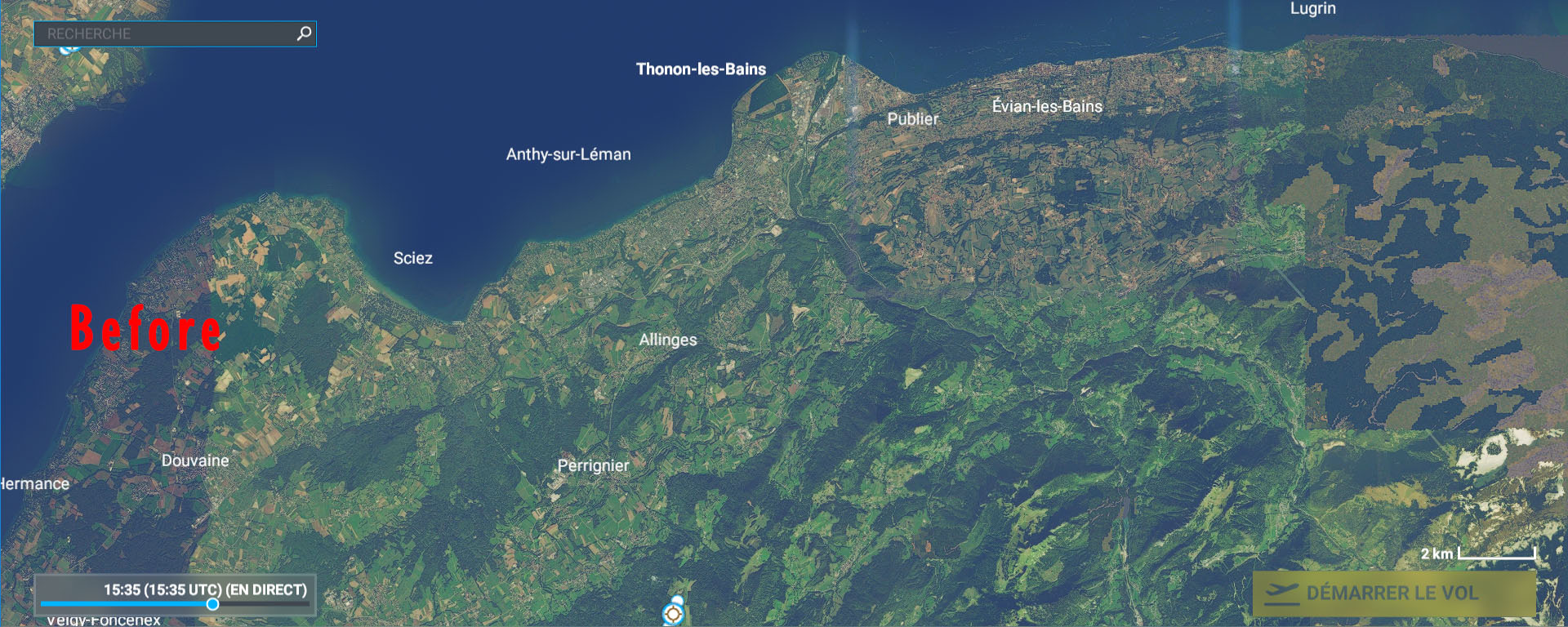
Since the MSFS BingMap imagery is of poor quality, or even replaced by generic textures on some mountain ranges in the Haute-Savoie department (74), this supplement, produced with the source of the BD ORTHO® OpenData aerial photographs from IGN allows to correct this problem very advantageously. The resolution is 2.39 m (Lod16) on all the massifs benefiting from this patch.
Installation: extract then copy and paste in your "Community" directory
Thanks to:
Microsoft
Asobo
MSFS Toolkit by Nool Aerosystems
Copyright: ftsxlw
ftsx.free.lw@gmail.com
Exclusively for free distribution and subject to the express authorization of the author.
Alpes Française - Département de Haute-Savoie (74) 1.0.0
L'imagerie BingMap de MSFS étant de mauvaise qualité, voire remplacé par des textures génériques sur quelques massifs montagneux du département de Haute-Savoie (74), ce complément, réalisé avec la source des photographies aériennes BD ORTHO® OpenData de l'IGN permet de corriger très avantageusement ce problème. La résolution est de 2.39 m (Lod16) sur tous les massifs bénéficiant de ce correctif.
https://fr.wikipedia.org/wiki/Haute-Savoie
Installation : extraire puis copier-coller dans votre répertoire « Community »
Merci à:
Microsoft
Asobo
MSFS Toolkit by Nool Aerosystems
Copyright : ftsxlw
ftsx.free.lw@gmail.com
Exclusivement pour diffusion gratuite et soumise à autorisation expresse de l’auteur.
Comments(28)
Log in to join the discussion
Log Inalmost 5 years ago
Bonjour et merci.
J'ai pris vos scènes, et je tenais à vous remercier pour votre travail et votre partage.
almost 5 years ago
Fantastic...THX
almost 5 years ago
is this with new Mesh? Can you also do this with LOD 17 or LOD 18?
almost 5 years ago
Bonjour et merci pour ces superbes scènes que j'ai volées copieusement ces derniers jours !!
J'ai quand même un souci en remontant la vallée d'Abondance depuis Thonon jusque Châtel. Donc très proche de la Suisse (qui vient d'être mis à jour, peut-être est-ce la cause du bug). Une absence quasi totale de texture à moins d'y faire un pause de plusieurs dizaines de secondes, et encore si on fait demi-tour les textures ont disparu et reviennent "difficilement". C'est vraiment spécifique à ce coin, le reste de la Haute-Savoie comme la Savoie ne souffrent d'aucun problème. Mais c'est 5* quand même!
almost 5 years ago
Merci, ok je vais voir de ce côté pour tester !
almost 5 years ago
Cinq étoiles sans hésiter ! Très bel ensemble (73/74) pour un natif/résident/pilote des bords du lac d'Annecy (Saint Jorioz). Un super grand merci pour ce travail !
En fait je retire 1/100 d'étoile car ma maison/propriété est un peu loin de la réalité ...
Bravo
almost 5 years ago
Merci à vous ! Désolé pour votre habitat mais je ne sais pas faire les palaces, seulement les Châteaux !
almost 5 years ago
Many thanks for these improvements.
Could you let us know exactly the coverage of the change for 74 and 73?
Do you concider to extend this work to 38?
I am living in Crolles and dreaming about a better "dent de Crolles".
Best Regards
almost 5 years ago
Thank you, but concerning "La Dent de Crolles" it is rather of good quality in the simulation. I will make a zip gathering the .KMZ files to be opened with GoogleMap so that you can see the affected areas and yes I will continue on 38.
https://drive.google.com/file/d/1oR1JmYrYSb14u9_a_WecTqKV4Y7qtbcq/view?usp=sharing
almost 5 years ago
Je crois qu'il y a un conflit avec vos scènes, j'ai pris tout les pack de haute savoie (car je suis d'ici) et le jeu crash au moment ou je suis dans l'avion. ça fonctionne bien lorsque je supprime tout le pack ANNECY
almost 5 years ago
Bonjour et merci pour votre retour d'expérience.
Avez-vous d'autres DLC tiers dans votre dossier Community que mes DLC consacrés aux correctifs de l'imagerie aérial des Dpt 73 et 74 ?
Personnelement, je viens de re tester mes DLC sans rien d'autres que ceux-ci dans mon Community, vol test en CJ4 à 300 Kt à partie d'Annecy vers l'est puis quadrillage vers la fin de couverture du Dpt 73 et pas de CTD's.
Il y a des DLC tiers, comme des avions par exemple, qui aléatoirement sont appelés par le moteur de MSFS pour remplir les places de parking, qui pourraient être à l'origine de ses plantages. Essayer un vol uniquement avec mes DLC pour tester sur votre config.
almost 5 years ago
Je n'ai que Genève dans la "région".
Je viens de tester en retirant les 2 avions personnalisés que j'avais...
et Effectivement ça fonctionne !!!
Merci
almost 5 years ago
Merci pour le test et le retour !
almost 5 years ago
I like your new orthphotos very much, however, on my system using your addons it will almost always lead tot a CTD. What can i do to eliminate this problem?
almost 5 years ago
French Alps - Department of Haute-Savoie (74) 1.0.0 (3)
Enhance the MSFS BingMap imagery in the French Alps - Department of Haute-Savoie (74) with this add-on using BD ORTHO® OpenData aerial photographs from IGN. Correct poor quality textures on mountain ranges with a 2.39m resolution (Lod16) across all affected areas. Enjoy improved visual fidelity in this stunning region for a more immersive flying experience.
User Reviews
11 reviews
Location
More Information
Version History
No version history available.
Related

Swiss mountains tree fix (trees on mountains removed)
A comprehensive mod fixing tree placement on Swiss mountains, particularly removing inaccurately placed trees on mountain peaks. The update includes a shift to more realistic conifer trees in the Alps and an expansion to border areas of France, Italy, and Austria. From Alpstein Säntis to Stockhorn, numerous locations across Switzerland have been meticulously corrected for a more authentic flight experience.
by THEOLI4D

Shorter Trees / Tree Height Modification VERSION 4.0 for MFS2020 (shorter, realistic trees)
Experience realistic and shorter trees in Microsoft Flight Simulator with the Shorter Trees / Tree Height Modification VERSION 4.0 add-on. Compatible with the latest version of MSFS, this mod provides adjusted tree heights for a more authentic flying experience. Update includes enhanced tree coloration blending seamlessly with photogrammetry trees. Installation is simple - just copy the folder into your community folder and enjoy a new perspective from the skies.
by ARIF STUDIOS - Adnan Arif

AUSTRIA 10m DEM - High Resolution Terrain Elevation Data from LIDAR Imaging
Explore the stunning terrain of Austria with this mod featuring high-resolution LIDAR data, offering a mesh resolution of 10m for a more realistic flight experience. Flatten lakes, rivers, and eliminate any terrain artifacts as you soar over the Austrian landscape. Divided into regions for convenience and performance optimization, this mod enhances the mountain shapes to mirror reality and provides a smoother flying experience. Experience Austria like never before with enhanced elevation data and realistic terrains.
by Troglodytus

SWITZERLAND 20m DEM - High Resolution Terrain Elevation Data from LIDAR Imaging
Explore the beauty of Switzerland with this mod offering high resolution terrain elevation data using LIDAR imaging. The mesh resolution is 20m, providing exceptional detail with a height resolution of 0.1m. Update includes extreme LIDAR meshes for specific regions. Please note potential performance impacts and report any bugs for further improvements. Fly VFR over Switzerland with enhanced realism and accuracy.
by Troglodytus
almost 2 years ago