Description
Experience New Zealand (Part 2 of 2 - Files 3 and 4 of 4)
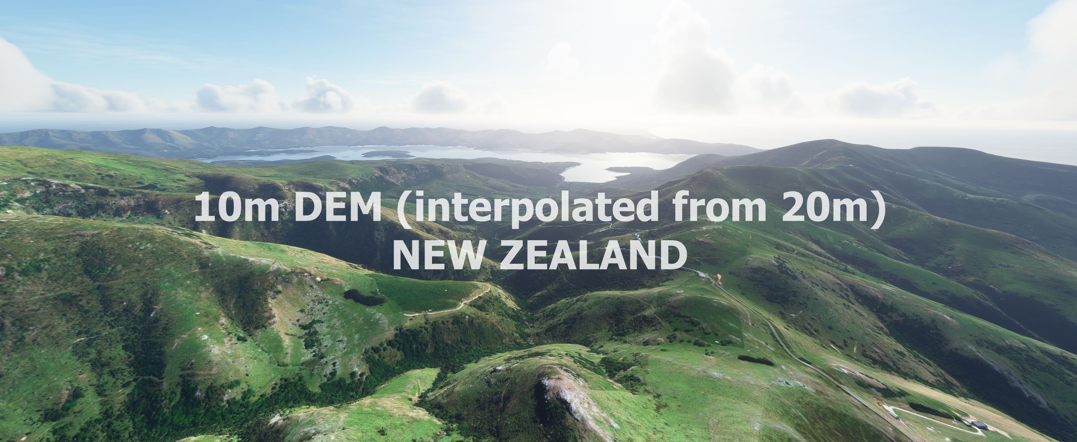
This mod contains customized height profiles. The mod contains a 10m elevation profile interpolated out of a 20m elevation model. (LINZ - Land Information New Zealand)
Many airports are already excluded.
Installation
Download Part 1 - File 1 and 2, Part 2 - File 3 and 4.
Extract all 4 files to the community folder everything will be in one folder at the end. All files merge into each other. (you can overwrite existing files)
IMPORTANT
Disclaimer: The creator of this mod is not responsible for any problems, damage, incompatibilites to other mods or performance issues that might occur.
Please note, that this mod is a very high resolution mesh. The elevation data is applied through terraforming rectangles, thus loaded at a certain distance from the player. When travelling fast or at high alitude (wide range of view) there might be too many new rectangles loaded simultaneously and thus stutters might occure.
If you have any stutters you can try and reduce your ingame render settings or uninstall!
If you are mainly flying airliners in high altitude, there is probably no benefit for you in using this mod.
Credits
The elevation data: (https://data.linz.govt.nz/layer/51768-nz-8m-digital-elevation-model-2012/)
This 8m Digital Elevation Model (DEM) was originally created by Geographx (geographx.co.nz) and was primarily derived from January 2012 LINZ Topo50 20m contours (data.linz.govt.nz/layer/768).
It was then transfered into MSFS using MSFS Toolkit by Nool Aerosystems (https://msfs.nool.ee/)
Thank you both and for anyone reading this: Please go ahead and support them!
Thanks Troglodytus for your help!
Enjoy your VFR flights above New Zealand!
Dependencies
Comments(26)
Log in to join the discussion
Log Inover 2 years ago
This implies that about half of the country is not covered. I would like to get complete coverage as I think this DEM is an enhancement.
I've only tried it near where I grew up, around south Hawkes Bay (Akitio, Cape Turnagain) and to me the scenery seems more realistic (PS, I'm a newbie , but I have considerable experience using Google Earth... about 10 years ago.. 90m DEM then..). I've not had any performance problems so far (PC has an Intel i9 12900 CPU and GeForce RTX3070)
Update: I found an article on why orbx pulled their NZ DEM ( https://forum.orbxdirect.com/topic/217215-information-regarding-nz-mesh-for-microsoft-flight-simulator/ ) and maybe the issue here is similar. So I did some comparisons of scenery against the default at Cape Turnagain... very little difference except for the shoreline... this addon looked better. Flying around Mt Cook I couldn't spot any differences.
It would be nice to know just what DEM's MSFS2020 is using . Looking forward to MSFS2024.... hopefully better resolution..
almost 4 years ago
Just confirming that this mod has caused major stability problems for me every time I've tried it in the past several months... and I'm curious, does anyone out there still use this mod without issue, or did you move to a different mesh?
almost 4 years ago
The method we used to make these DEM mods where never recommended for this kind of scale. It was meant for airport areas and not for whole countries. So that was more like a tech demo :D some sim updates ago it was working very well.
almost 4 years ago
Aye, 'twas better than the orbx version... maybe one day when things settle down; or maybe Asobo will accidentally fix it themselves 🤷
Is your Canary Islands mesh broken as well; I haven't been that way in a while but that one is so unique, it would be a shame as in a way it really gave photogrammetry a run for its money and I was looking forward to checking it out again when my cpu could run that together with the google map high LOD option without melting like those volcanos.
almost 5 years ago
Are there any word on possible updates to this as it seems there are some issues? thanks!
about 5 years ago
I am lost?
Why don't you put all the files in one folder....?
Then all we have to d is place that one folder into the Community folder?
Many thanks for this great work..
Robert
about 5 years ago
Everything looks great! I would love if someone could do something like this with Chile <3
about 5 years ago
Amazing work! Have made it from Queenstown to Picton so far and crossing the Cook straight today. Everything looks amazing but found a big trench like section missing just north of Kaikoura.
about 5 years ago
Do we need to download anything else besides the 'main file' in each of the two mods? I'm confused by there being files 1 & 2 in the first download, and 3 & 4 in the second. To me, it just looks like two downloads.
about 5 years ago
Yes every part contains 2 files so you have to download 4 files in total. :)
about 5 years ago
As another user has already stated this is a "game changer". Absolutely brilliantly done which takes NZ looking from trash to looking the way it should. I've experienced a minor drop in FPS running at Ultra settings but nothing major. Thank you very much for getting this to the people mate.
about 5 years ago
Great work on all this freeware mesh- it has been a game changer for the sim. One thing I have noticed is that D'Urville Island (large 150 km² island in the Marlborough Sounds) has been textured with sea instead of landmass. Looks very bizarre!
about 5 years ago
i tested a flight around queenstown and the landscape at north is incredible, fantastic : Greats peaks with vertiginous slopes end deep valleys with fjords too....it's a landscape unique in the world....Thank you for this great job who permit me to realise how New Zeland is an incrédible Geographic country....Incredible
NEW ZEALAND 10m DEM - High Resolution Terrain Elevation Data interpolated from 20m - Part 2
High Resolution Terrain Elevation Data for New Zealand (Part 2 of 2) featuring a 10m elevation profile interpolated from a 20m model. Customized height profiles and detailed mesh for immersive VFR flying experiences. Compatible with MSFS, installation instructions include downloading and extracting all files to the community folder. Disclaimer: Potential performance issues at high speeds or altitudes due to loading of high-resolution terraforming rectangles.

Supporters
User Reviews
5 reviews
More Information
Version History
No version history available.
Related

Swiss mountains tree fix (trees on mountains removed)
A comprehensive mod fixing tree placement on Swiss mountains, particularly removing inaccurately placed trees on mountain peaks. The update includes a shift to more realistic conifer trees in the Alps and an expansion to border areas of France, Italy, and Austria. From Alpstein Säntis to Stockhorn, numerous locations across Switzerland have been meticulously corrected for a more authentic flight experience.
by THEOLI4D

Shorter Trees / Tree Height Modification VERSION 4.0 for MFS2020 (shorter, realistic trees)
Experience realistic and shorter trees in Microsoft Flight Simulator with the Shorter Trees / Tree Height Modification VERSION 4.0 add-on. Compatible with the latest version of MSFS, this mod provides adjusted tree heights for a more authentic flying experience. Update includes enhanced tree coloration blending seamlessly with photogrammetry trees. Installation is simple - just copy the folder into your community folder and enjoy a new perspective from the skies.
by ARIF STUDIOS - Adnan Arif

AUSTRIA 10m DEM - High Resolution Terrain Elevation Data from LIDAR Imaging
Explore the stunning terrain of Austria with this mod featuring high-resolution LIDAR data, offering a mesh resolution of 10m for a more realistic flight experience. Flatten lakes, rivers, and eliminate any terrain artifacts as you soar over the Austrian landscape. Divided into regions for convenience and performance optimization, this mod enhances the mountain shapes to mirror reality and provides a smoother flying experience. Experience Austria like never before with enhanced elevation data and realistic terrains.
by Troglodytus

SWITZERLAND 20m DEM - High Resolution Terrain Elevation Data from LIDAR Imaging
Explore the beauty of Switzerland with this mod offering high resolution terrain elevation data using LIDAR imaging. The mesh resolution is 20m, providing exceptional detail with a height resolution of 0.1m. Update includes extreme LIDAR meshes for specific regions. Please note potential performance impacts and report any bugs for further improvements. Fly VFR over Switzerland with enhanced realism and accuracy.
by Troglodytus
over 2 years ago