Description
Experience New Zealand (Part 1 of 2 - Files 1 and 2 of 4)
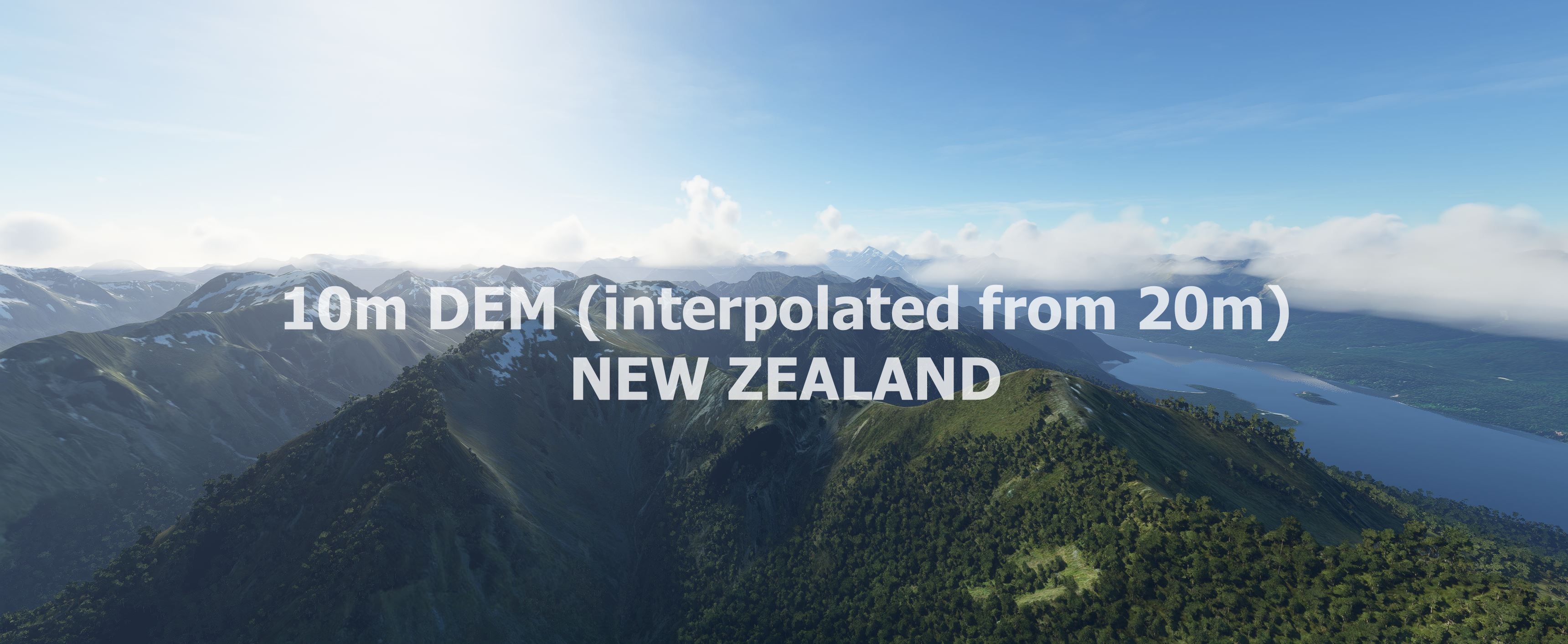
This mod contains customized height profiles. The mod contains a 10m elevation profile interpolated out of a 20m elevation model. (LINZ - Land Information New Zealand)
Many airports are already excluded.
Installation
Download Part 1 - File 1 and 2, Part 2 - File 3 and 4.
Extract all 4 files to the community folder everything will be in one folder at the end. All files merge into each other. (you can overwrite existing files)
IMPORTANT
Disclaimer: The creator of this mod is not responsible for any problems, damage, incompatibilites to other mods or performance issues that might occur.
Please note, that this mod is a very high resolution mesh. The elevation data is applied through terraforming rectangles, thus loaded at a certain distance from the player. When travelling fast or at high alitude (wide range of view) there might be too many new rectangles loaded simultaneously and thus stutters might occure.
If you have any stutters you can try and reduce your ingame render settings or uninstall!
If you are mainly flying airliners in high altitude, there is probably no benefit for you in using this mod.
Credits
The elevation data: (https://data.linz.govt.nz/layer/51768-nz-8m-digital-elevation-model-2012/)
This 8m Digital Elevation Model (DEM) was originally created by Geographx (geographx.co.nz) and was primarily derived from January 2012 LINZ Topo50 20m contours (data.linz.govt.nz/layer/768).
It was then transfered into MSFS using MSFS Toolkit by Nool Aerosystems (https://msfs.nool.ee/)
Thank you both and for anyone reading this: Please go ahead and support them!
Thanks Troglodytus for you help!
Enjoy your VFR flights above New Zealand!
Dependencies
Comments(30)
Log in to join the discussion
Log Inabout 4 years ago
Looking fine and working well in areas like around Christchurch (over plains and mountains too) but it crashes every time in the southern part like around Milford Sound and Invercargill. I also have some NZ bush airports installed, I'll make a try deleting them but I'm open to any other suggestions. Would be a top product if I could solve these issues!
over 4 years ago
Hey Mike - I would love to fly more with this but I am encountering way too much stuttering. Any idea what I could do to improve that?
over 4 years ago
Awesome mesh, redefines nz.
Heads up to the dev, there is a small issue with missing terrain on the seaward kaikouras near ohau point, with missing data. No terrain is shown.
over 4 years ago
I'm crashing into invisible mountains! At least that's what it looks like: I'm getting random altitude warnings of my plane, then the plane actually crashes into something.
Noticed in the Queenstown - Milford Sound area. Exact ccordinates of one of the crash points (there are others): -44.769869,168.126634; flying clearly above ground level (100+ ft)
Can you tell me if this is a side effect of this mod / if I can do something to prevent that?
Would be a shame to uninstall it - these mountains look far better than the default DEM!
almost 5 years ago
I have placed both files into the Community Folder and they show up in the Content Manager but there remain "Not Installed". What is the problem? Other files eg the Vertigo aircraft from flightsim.to installed no problem.
almost 5 years ago
Sorted. Hint for Noobs - be aware that the "mikeaat-dem-newzealand" folder must be in the Community folder rather than a sub folder of the extracted files after extraction into the Community folder.
about 5 years ago
Sadly too much stuttering with this scenery on Intel I5 and RTX 2060super 32 GB Ram. Nice in-between the stuttering though
about 5 years ago
Do you use a HDD or a SSD for your community folder?
about 5 years ago
500 gb SSD with about 100 gb remaining
about 5 years ago
Hi, probably a stupid question. In which order do I copy the files? Do I start with part 1 being overwritten by part 2 which is overwritten by Part 3 etc... or vice versa? Thx for your mod! ;-)
about 5 years ago
that does not matter. the files that get overwritten are identical in every file :)
about 5 years ago
Flew from Queenstown to Milford Sound. Really nice, but I have to say Milford Sound didn't look too great, lots of artifacts. But the Queenstown area looked as it should.
(I note the comments below - I will disactivate the NZMF scenery and have another look at the area - thanks)
about 5 years ago
The freeware NZMF addon doesn't work well with this mesh (not Mike's fault) ... but neither does ORBX's. I already asked the NZMF author if he's likely to update, be he said no ... :(
about 5 years ago
Just an FYI, NZMF was updated for this mesh today.
about 5 years ago
Unbelievable total awesomeness!! Well done! I was too busy gawping to even take screenshots ... now that, for me, is quite an achievement!
about 5 years ago
I found a huge gap and uploaded a screenshot under user gallery with the coordinates.It is only a remark , to this beautiful work.Or maybe it is the boarder line between two parts?
NEW ZEALAND 10m DEM - High Resolution Terrain Elevation Data interpolated from 20m - Part 1
Enhance your VFR experience with the high-resolution terrain elevation data for New Zealand. This mod features a 10m elevation profile derived from a 20m model, excluding many airports for a seamless flight experience. Be mindful of potential performance issues related to the detailed mesh, especially at high speeds or altitudes. Explore the stunning landscapes of New Zealand in Microsoft Flight Simulator with this meticulously crafted add-on.

Supporters
User Reviews
5 reviews
More Information
Version History
No version history available.
Related

Swiss mountains tree fix (trees on mountains removed)
A comprehensive mod fixing tree placement on Swiss mountains, particularly removing inaccurately placed trees on mountain peaks. The update includes a shift to more realistic conifer trees in the Alps and an expansion to border areas of France, Italy, and Austria. From Alpstein Säntis to Stockhorn, numerous locations across Switzerland have been meticulously corrected for a more authentic flight experience.
by THEOLI4D

Shorter Trees / Tree Height Modification VERSION 4.0 for MFS2020 (shorter, realistic trees)
Experience realistic and shorter trees in Microsoft Flight Simulator with the Shorter Trees / Tree Height Modification VERSION 4.0 add-on. Compatible with the latest version of MSFS, this mod provides adjusted tree heights for a more authentic flying experience. Update includes enhanced tree coloration blending seamlessly with photogrammetry trees. Installation is simple - just copy the folder into your community folder and enjoy a new perspective from the skies.
by ARIF STUDIOS - Adnan Arif

AUSTRIA 10m DEM - High Resolution Terrain Elevation Data from LIDAR Imaging
Explore the stunning terrain of Austria with this mod featuring high-resolution LIDAR data, offering a mesh resolution of 10m for a more realistic flight experience. Flatten lakes, rivers, and eliminate any terrain artifacts as you soar over the Austrian landscape. Divided into regions for convenience and performance optimization, this mod enhances the mountain shapes to mirror reality and provides a smoother flying experience. Experience Austria like never before with enhanced elevation data and realistic terrains.
by Troglodytus

SWITZERLAND 20m DEM - High Resolution Terrain Elevation Data from LIDAR Imaging
Explore the beauty of Switzerland with this mod offering high resolution terrain elevation data using LIDAR imaging. The mesh resolution is 20m, providing exceptional detail with a height resolution of 0.1m. Update includes extreme LIDAR meshes for specific regions. Please note potential performance impacts and report any bugs for further improvements. Fly VFR over Switzerland with enhanced realism and accuracy.
by Troglodytus
about 1 year ago