Description
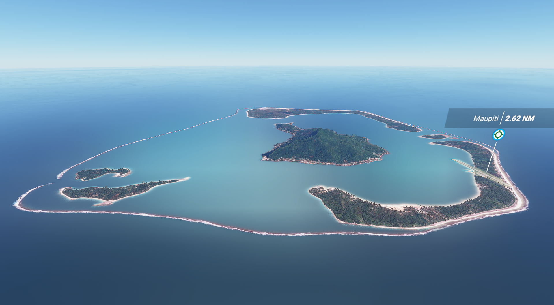
Maupiti Islands.
It's a small coral atoll with a volcanic island in its midst. It has a population of 1,200 people living on 11 square kilometres (4.2 square miles).
Waiting for the water blur mask version to have transparent water (need docs from SDK staff).
This mod is associated with the NTTP Maupiti Airport :
https://flightsim.to/file/4574/nttp-maupiti-airport-french-polynesia
PS : It's not a "landmark", it's not a "mountain"... maybe flightsim.to have to change the "mountain" category to "landscape" ?!
You can support me with a donation.
Donate
Comments(10)
Log in to join the discussion
Log Inalmost 5 years ago
you are my hero all french polynesia for mfs 2020
almost 5 years ago
Can you please have your files available in ZIP.? I cannot download it otherwise. Thanks
about 5 years ago
over 5 years ago
Super boulot dans tout ce que tu as déjà fait. Si tu as encore de l energie et une hésitation sur une prochaine île ou un atoll je vote pour l atoll de Hao et sa piste de ouf. Base arrière militaire à l epoque du nucléaire ????
over 5 years ago
Maupiti Island (French Polynesia)
Explore the beauty of Maupiti Island in French Polynesia, a small coral atoll with a volcanic island at its center. Experience a population of 1,200 living on this 11 square kilometer paradise. Discover transparent water with the awaited water blur mask version update. Dont miss out on the associated NTTP Maupiti Airport for a complete experience.

User Reviews
2 reviews
Location
More Information
Version History
No version history available.
Related

Swiss mountains tree fix (trees on mountains removed)
A comprehensive mod fixing tree placement on Swiss mountains, particularly removing inaccurately placed trees on mountain peaks. The update includes a shift to more realistic conifer trees in the Alps and an expansion to border areas of France, Italy, and Austria. From Alpstein Säntis to Stockhorn, numerous locations across Switzerland have been meticulously corrected for a more authentic flight experience.
by THEOLI4D

Shorter Trees / Tree Height Modification VERSION 4.0 for MFS2020 (shorter, realistic trees)
Experience realistic and shorter trees in Microsoft Flight Simulator with the Shorter Trees / Tree Height Modification VERSION 4.0 add-on. Compatible with the latest version of MSFS, this mod provides adjusted tree heights for a more authentic flying experience. Update includes enhanced tree coloration blending seamlessly with photogrammetry trees. Installation is simple - just copy the folder into your community folder and enjoy a new perspective from the skies.
by ARIF STUDIOS - Adnan Arif

AUSTRIA 10m DEM - High Resolution Terrain Elevation Data from LIDAR Imaging
Explore the stunning terrain of Austria with this mod featuring high-resolution LIDAR data, offering a mesh resolution of 10m for a more realistic flight experience. Flatten lakes, rivers, and eliminate any terrain artifacts as you soar over the Austrian landscape. Divided into regions for convenience and performance optimization, this mod enhances the mountain shapes to mirror reality and provides a smoother flying experience. Experience Austria like never before with enhanced elevation data and realistic terrains.
by Troglodytus

SWITZERLAND 20m DEM - High Resolution Terrain Elevation Data from LIDAR Imaging
Explore the beauty of Switzerland with this mod offering high resolution terrain elevation data using LIDAR imaging. The mesh resolution is 20m, providing exceptional detail with a height resolution of 0.1m. Update includes extreme LIDAR meshes for specific regions. Please note potential performance impacts and report any bugs for further improvements. Fly VFR over Switzerland with enhanced realism and accuracy.
by Troglodytus
almost 5 years ago
Great work. Please keep improving French Polynesia. Thanks.