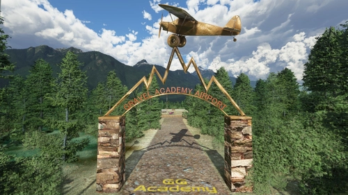
Description
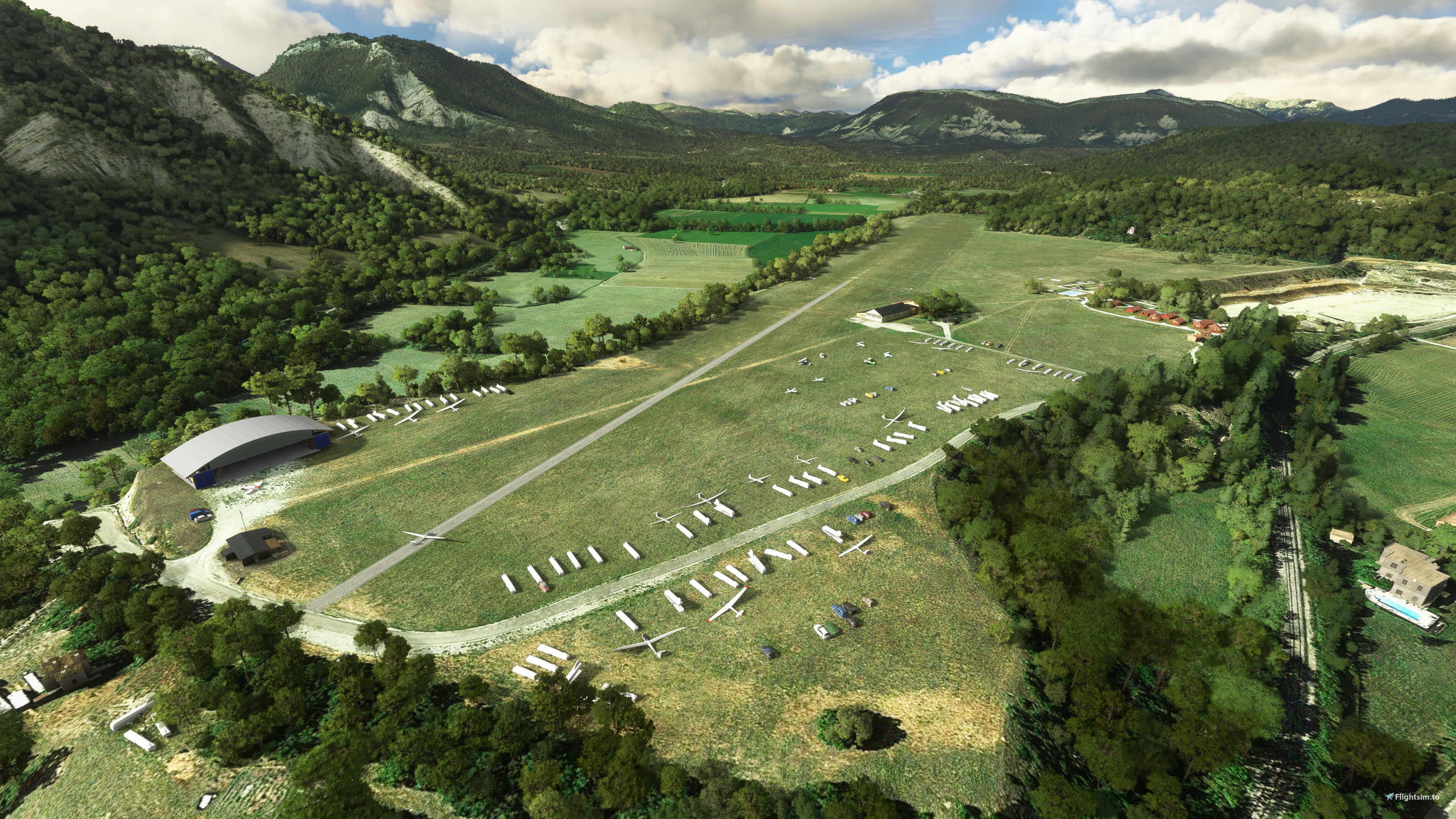
La Bâtie-Montsaléon is a commune in the Hautes-Alpes department in southeastern France and the Serres La Batie Montsaleon Airport (LFTM) is home to the very popular Eagles Alpine Soaring Academy.
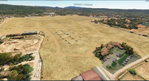
The 18/36 grass runway (2133' long x 295' wide) is perfectly located to explore the hills and mountains in your glider or light aircraft.
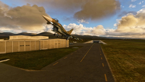
A Robin DR300 is used as a tug plane for launches (typically from runway 36 and Kinetic Assistant by TouchingClouds can be used if your glider doesn't have it's own launch capabilities.
Parking spots are available for visiting pilots and visitors are invited to use the on-site cafe and the lodges can be used should you wish to spend a few days in the region.
The gliders on the field are from the Mike.at asset library and is strongly recommended.
Custom models and Google earth data have been used to make this gliding mecca something very special.
My thanks goto ANRI, twoseventyinc and Mike.at for the models.
Dependencies
Comments(18)
Log in to join the discussion
Log Inabout 3 years ago
salut, la scène fonctionne avec s12
almost 4 years ago
nouvelle série de screens en hélico..merci pour la scène
almost 4 years ago
salut de Perpignan. Superbe scène OK S10-11 merci pour ce travaiol
about 4 years ago
As if you really there fantastic job thank you!!
over 4 years ago
nice to see you building scenery on France !

over 4 years ago
Salut ayant fait un vol sur ce terrain impossible de voir la manche à air du ciel est il possible de la faire apparaitre de plus loin (l'astuce consiste a lier un objet avec un cube sous terre par exemple dans votre logiciel3D (perso j'utilise Blender) pour ui donner une taille virtuelle plus grosse. Si c'est une manche de votre conception c'est parfait pour faire cela, si c'est un objet tiers je sais pas. Dans tous les cas la voir du ciel serait un plus réaliste. Merci.
over 4 years ago
Hi, the windsock is provided by the Windy-things library so I have no control over it's visibility at a distance. I could put the generic Asobo windsock into the scenery but that is completely unrealistic for this location.
Kev
over 4 years ago
I think we need a library from free object some windsocks and other, I work for that, stay tuned. :-)
over 4 years ago
Thank you :)
over 4 years ago
Super travail !! Merci pour ce partage
over 4 years ago
super bravo un coin que je connais bien
pourrais tu eventuellement faire LFNJ juste a coté ??
merci beaucoup
over 4 years ago
only 10km north of this site, I will take a look at it. Kev
over 4 years ago
thank's a lot i will be very happy if you can make LFNJ
over 4 years ago
Just a basic edit so far, replacing bing with google data, contouring the plateau and deleting the offices pretending to be hangers https://drive.google.com/file/d/141qp-Fl_HH2u0KWd_OGvLvq5RO9IzxL9/view?usp=sharing
over 4 years ago
it's a very good start thank you
now 3d buildings would be a must have for this location
https://fr.flightsim.to/request/scenery/3580/lfnj-aspres-sur-buech-05-hautes-alpes
over 4 years ago
My favorite airfield! I adore him and love to fly in its surroundings. Many thanks to Photosbykev
over 4 years ago
Very nice airfield, thank you!
Serres La Batie Montsaleon Airport (LFTM) Gliding in France
Explore the stunning hills and mountains of La Batie-Montsaleon in southeastern France with the Serres La Batie Montsaleon Airport (LFTM) add-on. Home to the Eagles Alpine Soaring Academy, this scenic location features an 18/36 grass runway perfect for gliders and light aircraft. Enjoy the use of a Robin DR300 tug plane for launches and parking spots for visiting pilots. Immerse yourself in this gliding mecca with custom models and Google Earth data enhancements.

User Reviews
8 reviews
Location
More Information
Version History
No version history available.
Featured in Collections(1)

Related
The Gotgravel STOL Academy at Squamish, BC (CYSE)
Explore the back country of British Columbia with the GotGravel Academy at Squamish Airport (CYSE). This add-on offers 40 off-airport landing strips and two dedicated STOL strips for competitive events and practice. Immerse yourself in the art of STOL flying and enjoy custom pylon racing circuits alongside the Squamish river. Join the GotGravel discord for support and make sure to have the recommended libraries installed for the best experience.
by Photosbykev
Llanbedr Airport (EGOD) 'The Gateway to the Mach Loop'
Explore Llanbedr Airport (EGOD), known as The Gateway to the Mach Loop in North Wales, UK. This scenic airfield is a hub for VIP landings, aerospace testing, training, and events, with a flying school offering lessons and aerobatic experiences. It features a unique underground shelter for military response, FAA identifier EGOD, and specific parking for military jets and GA planes. Be cautious of military activity in the area and enjoy access to coastal float planes for dolphin sightings.
by Photosbykev
Cougar Basin (PZ12) Idaho playground
Discover Cougar Basin (PZ12) Idaho, a unique scenery playground for Microsoft Flight Simulator enthusiasts. This regularly updated add-on features a grass/rock runway, custom buildings, and scenery animations. Nestled among popular airstrips in Idaho, this playground offers a picturesque setting for small GA planes and float planes to explore. Stay tuned for new ideas and additions from the developers creative mind.
by Photosbykev

Warm Lake Shoreline airport, Idaho
Explore the backcountry of Idaho with Warm Lake Shoreline airport (PZ10) featuring a 1300 grass/shale runway and seaplane facilities. Enjoy the amenities of a nearby community and the renowned WP8 cafe. Watch out for local wildlife and utilize various library assets for an immersive experience.
by Photosbykev
about 2 years ago