Description
This MSFS2024 scenery is a fix for my 2020 scenery of "Décor de Saint-Nazaire + Pornichet + La Baule" available here: https://flightsim.to/file/7084/eglise-de-saint-nazaire
La version 3.1 corrige des problèmes de compatibilité avec VFR44-1 West Loire-Atlantique France Landmark Scenery Pack, et corriges les doubles ombres au sol créées par les chateaux d'eau ou éoliennes.
You need to keep/download MSFS2020 "Décor de Saint Nazaire" in your Community folder and add this one in the Community folder of MSFS2024.
In Addition this MSFS2024 scenery adds :
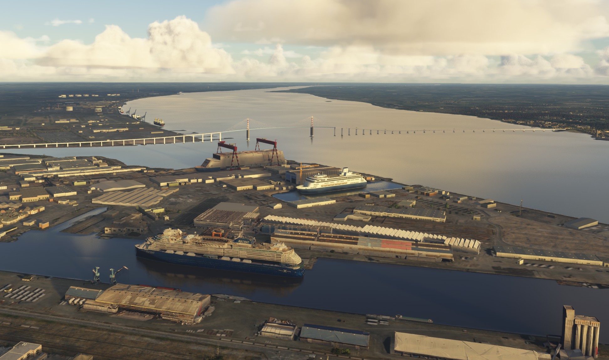
- New POI in Saint Nazaire (Centre Commercial Océanis, Centre Hospitalier, Gare, Ateliers sur les Chantiers de l'Atlantique, plus autres détails).
- New textures for the Marais Salants de Guérande
- Pen Bron + La Turballe
- Some fixes for the city of Guérande (walls)
- Moving boats in La Baule (you need to download Moving Boats library)
- New wind turbines for the Parc éolien de Saint Nazaire (compatible with France VFR addons)
- New model for Grand Portiques in Saint Nazaire (with 2024 lods and new model of ship in construction)
- Many other corrections (polygons) in the area from Saint-Nazaire to Guérande.
- I took the liberty to place back 2 buildings on the airport of La Baule https://flightsim.to/file/960/lfre-la-baule-escoublac
DEPENDENCIES:
1. Décor de Saint-Nazaire (2020) + Pornichethttps://flightsim.to/file/7084/eglise-de-saint-nazaire +
2. LFRE - La Baule-Escoublac for Microsoft Flight Simulator | MSFS https://flightsim.to/file/960/lfre-la-baule-escoublac
3. Moving Boats 3D Model Library for Microsoft Flight Simulator | MSFS https://flightsim.to/file/27908/moving-boats-3d-model-library
Comments
Log in to join the discussion
Log InNo comments yet. Be the first to share your thoughts!
Décor de Saint-Nazaire - Guérande fix 2024
Version 3.1 adresses compatibility issues with VFR44-1 West Loire-Atlantique France Landmark Scenery Pack. I also corrects issues with double shades of towers on ground. The Décor de Saint-Nazaire fix 2024 enhances the original scenery from 2020, introducing a variety of updates and corrections. It features new textures for the Marais Salants de Guérande, moving boats in La Baule, and improved wind turbines for the Parc éolien de Saint Nazaire. Additionally, it corrects polygons and includes updates for key locations, such as the Grand Portiques in Saint Nazaire and the La Baule airport.

Location
More Information
Version History
V3.1 Adresses compatibility issues with VFR44-1 West Loire-Atlantique France Landmark Scenery Pack and France VFR, and also eliminates double shadows from watertowers and wind turbines.
Related

Swiss mountains tree fix (trees on mountains removed)
A comprehensive mod fixing tree placement on Swiss mountains, particularly removing inaccurately placed trees on mountain peaks. The update includes a shift to more realistic conifer trees in the Alps and an expansion to border areas of France, Italy, and Austria. From Alpstein Säntis to Stockhorn, numerous locations across Switzerland have been meticulously corrected for a more authentic flight experience.
by THEOLI4D

Shorter Trees / Tree Height Modification VERSION 4.0 for MFS2020 (shorter, realistic trees)
Experience realistic and shorter trees in Microsoft Flight Simulator with the Shorter Trees / Tree Height Modification VERSION 4.0 add-on. Compatible with the latest version of MSFS, this mod provides adjusted tree heights for a more authentic flying experience. Update includes enhanced tree coloration blending seamlessly with photogrammetry trees. Installation is simple - just copy the folder into your community folder and enjoy a new perspective from the skies.
by ARIF STUDIOS - Adnan Arif

AUSTRIA 10m DEM - High Resolution Terrain Elevation Data from LIDAR Imaging
Explore the stunning terrain of Austria with this mod featuring high-resolution LIDAR data, offering a mesh resolution of 10m for a more realistic flight experience. Flatten lakes, rivers, and eliminate any terrain artifacts as you soar over the Austrian landscape. Divided into regions for convenience and performance optimization, this mod enhances the mountain shapes to mirror reality and provides a smoother flying experience. Experience Austria like never before with enhanced elevation data and realistic terrains.
by Troglodytus

SWITZERLAND 20m DEM - High Resolution Terrain Elevation Data from LIDAR Imaging
Explore the beauty of Switzerland with this mod offering high resolution terrain elevation data using LIDAR imaging. The mesh resolution is 20m, providing exceptional detail with a height resolution of 0.1m. Update includes extreme LIDAR meshes for specific regions. Please note potential performance impacts and report any bugs for further improvements. Fly VFR over Switzerland with enhanced realism and accuracy.
by Troglodytus