
Description
Churfirsten (Mountain Range) are seven Mountain Peaks between Walensee (Lake) and the Valley of Toggenburg in Canton St. Gallen (Switzerland). The highest Peak has an Elevation of 2,306m (7,566 ft). The southern front is very steep and on the eastern end there is a canyon very popular for Base Jumper (seen in the Movie Point Break II). The northern back of the Mountains is a pretty Skiing Area. The next Airports are Flugplatz Mollis LSZM (Swiss Airforce), and Flugplatz Bad Ragaz LSZE. The Highway in the Valley between Bad Ragaz and the Churfirsten once was used from Swiss Military as a Backup runway. Good luck when you try to land there!
GPS: 47°9′7″N 9°17′53″ECoordinates: 47°9′7″N 9°17′53″E
File:
The Scenery is a mix of two seasons. The Google Data are shot in Winter, the MSFS Data look like Summer.
Credits:
This scenery has been extracted from Google Maps, hence all 3D credits goes to Google.
This scenery has been generated with the Google Earth Decoder tool (credits to /u/Jonahex111):
https://www.reddit.com/r/FS2020Creation/comments/j3faaj/google_earth_decoder_now_userfriendly/
Installation:
Extract Scenery_Churfirsten in the Community folder. Don't forget to restart the Microsoft Flight Simulaor after that. Thats it!
Comments(18)
Log in to join the discussion
Log Inover 3 years ago
Is this missing in the sim or something?
over 3 years ago
not anymore since world update for switzerland
over 5 years ago
I'll write in English rather than German: Great work. It's so sad how the alps look in MSFS2020 :/
Glad to have some little improvements at least on some mountains thanks to mods like this. It looks good :).
Of course a summer version would be better, since I think the winter version would be automatically possible, but not the summerversion... but I know that's not your fault since the Google data simply shows the mountains in winter.
PLEASE do not forget to vote for this thread: https://forums.flightsimulator.com/t/disappointing-mountain-terrain-in-the-alps-and-many-other-areas/
The idea is to push Asobo to improve the terrain data of all mountains, especially of the alps. Please join that thread and push the "vote" button :).
over 5 years ago
säntis is nearly done. i think this weekend i can add it to flightsim. i hope its not to large. the problem with the season is the same, but its better then before
over 5 years ago
Herzlichen Dank :-)
over 5 years ago
over 5 years ago
und natürlich der ganze alpstein mit hohem kasten usw... wenn man schon nicht hochfahren darf zum brunchen im moment :-)
over 5 years ago
over 5 years ago
over 5 years ago
over 5 years ago
over 5 years ago
Danke!
over 5 years ago
over 5 years ago
Regards from Chur :-)
over 5 years ago
over 5 years ago
over 5 years ago
Churfirsten (Mountain Range) Switzerland
Explore the breathtaking Churfirsten mountain range in Switzerland, featuring seven peaks with the highest elevation of 2,306m. Known for its steep southern front and popular base jumping spots, the range offers a picturesque skiing area on its northern side. Experience the beauty of this iconic Swiss landscape in both winter and summer seasons.

User Reviews
6 reviews
Location
More Information
Version History
No version history available.
Related
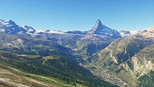
Matterhorn Mountain
Explore the stunning beauty of Matterhorn mountain with this add-on, featuring a fully photogrammetry-based model and terraformed edges for a more realistic experience. Version 2.0 includes new additions such as improved LOD levels, color-corrected textures, cable car pylons, and populated forests. Install by dragging the folder into your "Community" folder and enjoy the enhanced scenery around this iconic peak.
by NikPrist
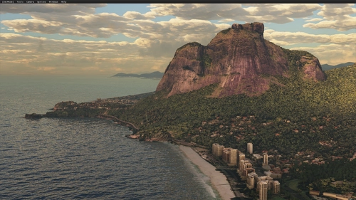
Rio de Janeiro Megapack Montanhas
Explore the detailed mountainous landscape of Rio de Janeiro in this updated megapack. Precisely positioned mountains like Pedra da Gávea and Pão de Açúcar using Google Maps models. Create your mod via Earth2MSFS for an effective import process. Stay tuned for further updates with optimized textures and added landmarks. Individualize your experience by adding specific mountain ranges to enhance your simulation.
by RodrigoMoraes94
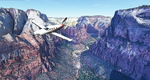
Zion Canyon National Park, Utah
Explore the breathtaking beauty of Zion Canyon National Park in Utah with this V1.0 scenery add-on. Discover well-known locations like the Zion Canyon Overlook, Angels Landing, and more. Experience corrected terrain heights and improved color blending for a more immersive flight simulation. Simply extract the file to your Community Folder and start your aerial adventure in this stunning national park.
by Jeppeson2001
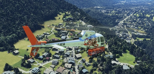
Chamonix-Mont-Blanc, Rhône-Alpes, France - Valley
Explore the stunning Chamonix-Mont-Blanc valley in Rhône-Alpes, France with this addon, including a semi-fictional DZ at Argentière. Enhance your experience by combining it with the Mountains addon. Download, extract into community folder, and enjoy photogrammetry and object data. This addon requires a minimum configuration for optimal performance.
by AdrianL
over 3 years ago
Great!!!