Description
This package contains better Orthophoto tiles around village Mauterndorf in Austria in the center of Lungau as the default areal imagery is very poor in that area...
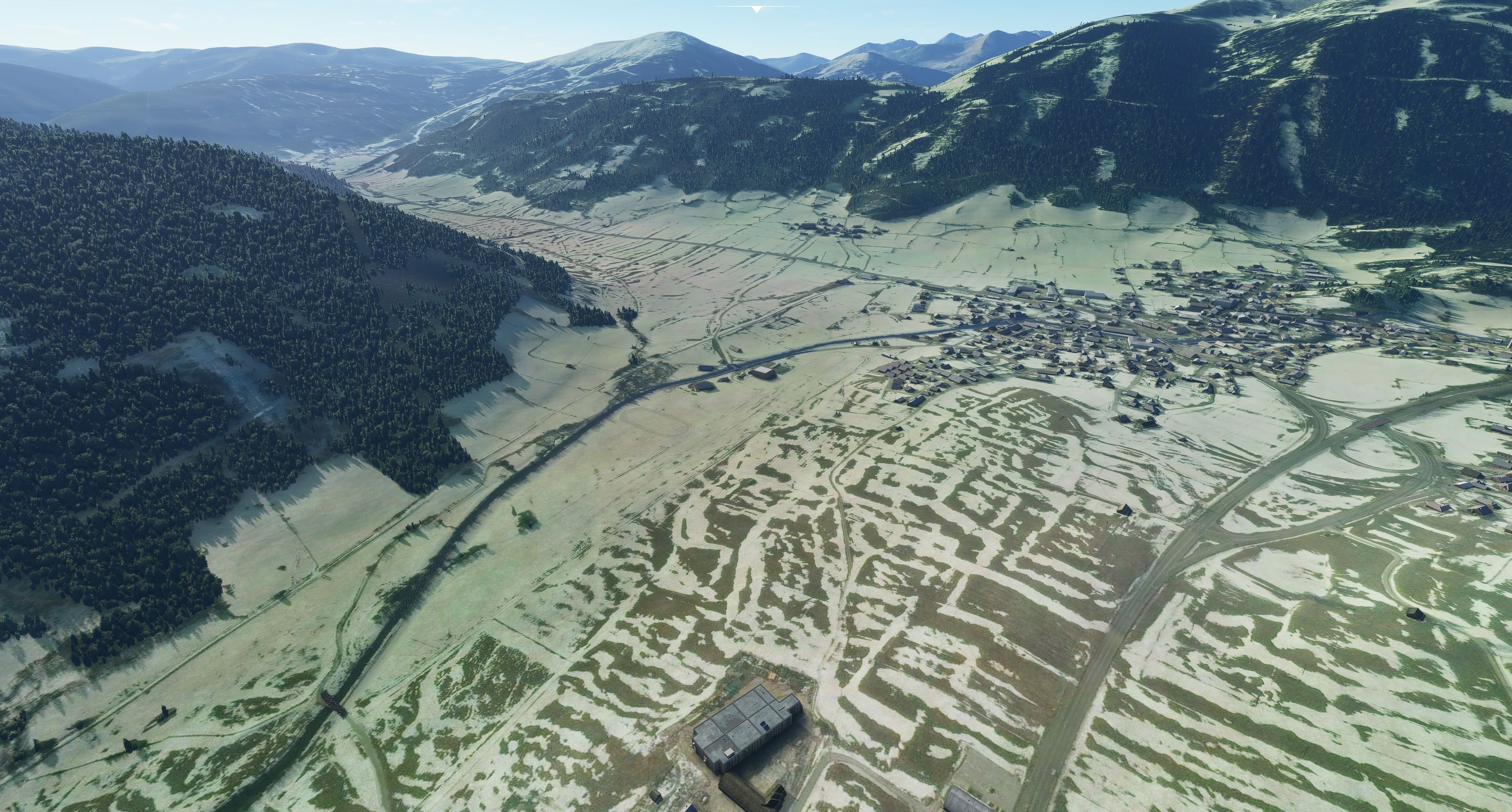
The resolution at village Mauterndorf and the small Airfield is ZL18 decreasing to ZL16 to the end of my tiles. On the edges of this package scenery is blending smoothly to original MSFS terrain. The source of that tiles is as well Bing Maps, but an older version of it (from summertime with clear skies).
As Airfield LOSM Mauterndorf is not included in MSFS by default, this Orthophoto package might be used together with beautiful "LOSM Mauterndorf" package from moonlander69
(https://flightsim.to/file/5818/mauterndorf-losm-highest-situated-airfield-in-austria), or with your own creation of LOSM.
Note: The screenshots included here have been made with my own version of LOSM Mauterndorf which is not content of that upload intentionally.
Installation: As usual, just unpack package folder from this zip-file and copy it into your community-folder. Enjoy!
Comments(10)
Log in to join the discussion
Log Inalmost 3 years ago
over 4 years ago
The Orthophoto package should still be compatible to SU5. No change or update should be needed. Whether it is still needed after WU6 needs to be decided by everybody for him/her-self. Just de-activate it and compare, what fits better to your expectations.
over 4 years ago
Is this still needed with the Austrian World update?
over 5 years ago
My wife and I love the Lungau. About 35 years now we spend our holidays there. But exploring the Lungau with the new MSFS2020 was disappointing because of the poor image quality there. Now real life comes into it!
(Didn't try it yet. Was just fascinated finding this here. Does it cover the whole Lungau? I explored the whole region with my E-bike, know almost every street ;-) Your version of LOSM is great! Do you intend to present it here in flightsim.to?
Thanks again! Appreciate your work!
over 5 years ago
Thank you for your job, i like it
over 5 years ago
over 5 years ago
Better Orthophoto for Mauterndorf in Austria
Enhance the aerial imagery around Mauterndorf in Austria with this package, featuring improved Orthophoto tiles at varying resolutions. Compatible with Airfield LOSM Mauterndorf add-on, this scenery seamlessly blends with the original MSFS terrain. Simply unzip and copy the files to your community folder for an upgraded visual experience.

User Reviews
4 reviews
Location
More Information
Version History
No version history available.
Related

Swiss mountains tree fix (trees on mountains removed)
A comprehensive mod fixing tree placement on Swiss mountains, particularly removing inaccurately placed trees on mountain peaks. The update includes a shift to more realistic conifer trees in the Alps and an expansion to border areas of France, Italy, and Austria. From Alpstein Säntis to Stockhorn, numerous locations across Switzerland have been meticulously corrected for a more authentic flight experience.
by THEOLI4D

Shorter Trees / Tree Height Modification VERSION 4.0 for MFS2020 (shorter, realistic trees)
Experience realistic and shorter trees in Microsoft Flight Simulator with the Shorter Trees / Tree Height Modification VERSION 4.0 add-on. Compatible with the latest version of MSFS, this mod provides adjusted tree heights for a more authentic flying experience. Update includes enhanced tree coloration blending seamlessly with photogrammetry trees. Installation is simple - just copy the folder into your community folder and enjoy a new perspective from the skies.
by ARIF STUDIOS - Adnan Arif

AUSTRIA 10m DEM - High Resolution Terrain Elevation Data from LIDAR Imaging
Explore the stunning terrain of Austria with this mod featuring high-resolution LIDAR data, offering a mesh resolution of 10m for a more realistic flight experience. Flatten lakes, rivers, and eliminate any terrain artifacts as you soar over the Austrian landscape. Divided into regions for convenience and performance optimization, this mod enhances the mountain shapes to mirror reality and provides a smoother flying experience. Experience Austria like never before with enhanced elevation data and realistic terrains.
by Troglodytus

SWITZERLAND 20m DEM - High Resolution Terrain Elevation Data from LIDAR Imaging
Explore the beauty of Switzerland with this mod offering high resolution terrain elevation data using LIDAR imaging. The mesh resolution is 20m, providing exceptional detail with a height resolution of 0.1m. Update includes extreme LIDAR meshes for specific regions. Please note potential performance impacts and report any bugs for further improvements. Fly VFR over Switzerland with enhanced realism and accuracy.
by Troglodytus
about 2 years ago