Description
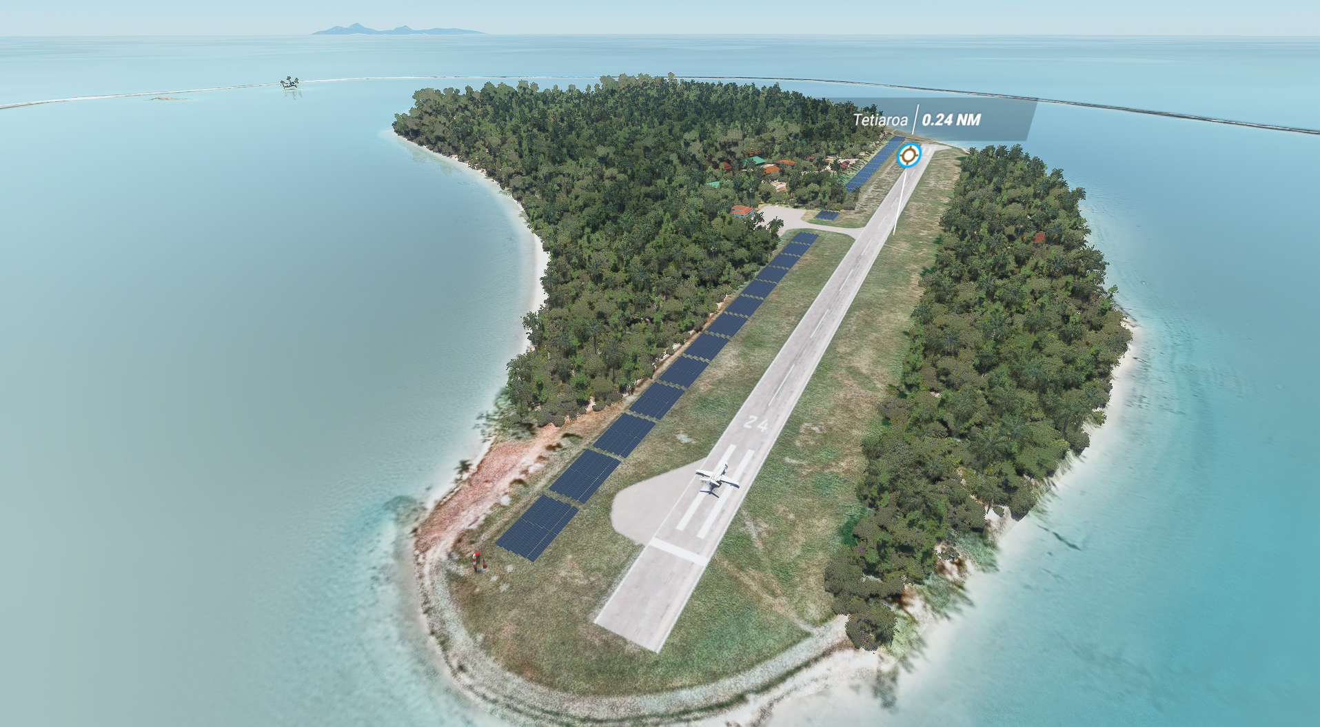
Teti'aroa is an atoll in the Windward group of the Society Islands of French Polynesia, an overseas territorial collectivity of France in the Pacific Ocean. Once the vacation spot for Tahitian royalty, the islets are under a 99-year lease contracted by Marlon Brando.
Waiting for the water blur mask version to have transparent water (need docs from SDK staff).
This mod is associated with the NTTE Teti'aroa Airport :
https://flightsim.to/file/4868/ntte-teti-aroa-airport-french-polynesia
This file is only for the Aerial !!! You need the other file to have the airport.
You can support me with a donation.
Donate
Comments(3)
Log in to join the discussion
Log Inover 5 years ago
Un excellent travail, hâte de voir l'aspect final avec les eaux transparentes.
Le récifs étaient-ils existants au préalable ou les avez-vous créés ?
Les récifs et les eaux transparentes manquent cruellement à l'île Maurice et le "Morne Brabant" (emblème de l'île) est horrible... Auriez-vous un conseil ou l'autre à me donner pour améliorer l'image de Maurice ?
Encore bravo pour le boulot !
over 5 years ago
I guess it will come in further updates, but here are somme suggestions :
1. Adding much more coconut trees to get the environement more realistic especialy in the islands whare there is mostly these trees.
2. Build/improve Tahiti Faaa (NTAA) Airport and its surroundings. The main airport of French Polynesia is total crap in FS2020 (not even the tower, buildings are awfull not at the right places and doesn't look as they are in real, activities and aircrafts etc...
But I guess it a lot of work, and I very happy of what you have already done. THANK YOU SO MUCH. Mauruuru. Fred
Tetiꞌaroa Island (French Polynesia)
Explore the scenic Tetiaroa Island in French Polynesia, once a retreat for Tahitian royalty and now leased by Marlon Brando. Discover this atoll in the Pacific Ocean with this add-on, featuring immersive details and a picturesque setting. Please note that the water blur mask version is pending for transparent water. For an extended experience, check out the associated NTTE Tetiaroa Airport add-on.

User Reviews
1 reviews
More Information
Version History
No version history available.
Related

Swiss mountains tree fix (trees on mountains removed)
A comprehensive mod fixing tree placement on Swiss mountains, particularly removing inaccurately placed trees on mountain peaks. The update includes a shift to more realistic conifer trees in the Alps and an expansion to border areas of France, Italy, and Austria. From Alpstein Säntis to Stockhorn, numerous locations across Switzerland have been meticulously corrected for a more authentic flight experience.
by THEOLI4D

Shorter Trees / Tree Height Modification VERSION 4.0 for MFS2020 (shorter, realistic trees)
Experience realistic and shorter trees in Microsoft Flight Simulator with the Shorter Trees / Tree Height Modification VERSION 4.0 add-on. Compatible with the latest version of MSFS, this mod provides adjusted tree heights for a more authentic flying experience. Update includes enhanced tree coloration blending seamlessly with photogrammetry trees. Installation is simple - just copy the folder into your community folder and enjoy a new perspective from the skies.
by ARIF STUDIOS - Adnan Arif

AUSTRIA 10m DEM - High Resolution Terrain Elevation Data from LIDAR Imaging
Explore the stunning terrain of Austria with this mod featuring high-resolution LIDAR data, offering a mesh resolution of 10m for a more realistic flight experience. Flatten lakes, rivers, and eliminate any terrain artifacts as you soar over the Austrian landscape. Divided into regions for convenience and performance optimization, this mod enhances the mountain shapes to mirror reality and provides a smoother flying experience. Experience Austria like never before with enhanced elevation data and realistic terrains.
by Troglodytus

SWITZERLAND 20m DEM - High Resolution Terrain Elevation Data from LIDAR Imaging
Explore the beauty of Switzerland with this mod offering high resolution terrain elevation data using LIDAR imaging. The mesh resolution is 20m, providing exceptional detail with a height resolution of 0.1m. Update includes extreme LIDAR meshes for specific regions. Please note potential performance impacts and report any bugs for further improvements. Fly VFR over Switzerland with enhanced realism and accuracy.
by Troglodytus
about 5 years ago