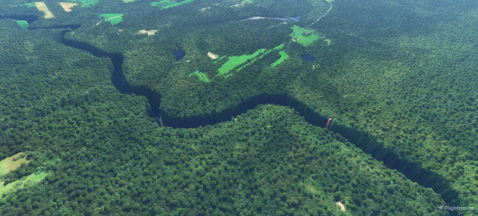
Description
IMPORTANT NOTE
Please note that since a couple of SDK updates, polygons are doing very strange things and make my work weird on certain circonstances. I'm awaiting some help to fix that.
SVP notez que depuis queleques updates du SDK, les polygones font des choses étranges et détruisent mon travail. J'attends de l'aide à ce niveau pour remédier à ça.
If you are using JPFIL "Cité de l'énergie" please not his mod is conflicting with mine.
Si vous utilisez le mod de JPFIL "Cité de l'énergie", prenez note que ce mod entre en conflit avec le mien.
VERY IMPORTANT
Please do not use anymore my previous version Quebec province trees and rivers corrections WIP.
You will need this mod to complete the rivers.
https://flightsim.to/file/45566/quebec-province-trees-corrections-wip
TRÈS IMPORTANT
SVP, n'utilisez plus ma précédante version Quebec province trees and rivers corrections WIP.
Vous aurez besoin de ce mod pour compléter les rivières.
https://flightsim.to/file/45566/quebec-province-trees-corrections-wip
Comments(87)
Log in to join the discussion
Log Inover 2 years ago
over 2 years ago
You are right, a coast to coast rework is needed but not from me.
over 2 years ago
Captain Moonlight
over 2 years ago
over 2 years ago
over 2 years ago
Merci à toi.
over 2 years ago
Super boulot !
J'ai encore un dénivelé d'eau à la base maritime de la Tuque :
https://flic.kr/p/2pmMgpn
https://flic.kr/p/2pmMgp7
Pourriez vous faire quelque chose ?
Merci pour votre MOD :)
over 2 years ago
over 2 years ago
over 2 years ago
Quand vous êtes sur la 03 c'est juste devant.
Les 1 ères photos sont avec votre addon et l'aérodromre de JPFillon
community vide avec votre mod :
https://flic.kr/p/2pmWP2Q
https://flic.kr/p/2pmUBqJ
over 2 years ago
Quebec province water corrections (closed)
This mod is intended to correct lakes and rivers elevation errors on the whole province. Ce mod a pour but de corriger les erreures d'élévations des lacs et rivières à travers toute la province.

Supporters
User Reviews
18 reviews
Location
More Information
Version History
Found lot of problematic lakes west of lac St-Jean. Trouvé beaucoup de lacs creux à l'ouest du lac St-Jean.
Related

Swiss mountains tree fix (trees on mountains removed)
A comprehensive mod fixing tree placement on Swiss mountains, particularly removing inaccurately placed trees on mountain peaks. The update includes a shift to more realistic conifer trees in the Alps and an expansion to border areas of France, Italy, and Austria. From Alpstein Säntis to Stockhorn, numerous locations across Switzerland have been meticulously corrected for a more authentic flight experience.
by THEOLI4D

Shorter Trees / Tree Height Modification VERSION 4.0 for MFS2020 (shorter, realistic trees)
Experience realistic and shorter trees in Microsoft Flight Simulator with the Shorter Trees / Tree Height Modification VERSION 4.0 add-on. Compatible with the latest version of MSFS, this mod provides adjusted tree heights for a more authentic flying experience. Update includes enhanced tree coloration blending seamlessly with photogrammetry trees. Installation is simple - just copy the folder into your community folder and enjoy a new perspective from the skies.
by ARIF STUDIOS - Adnan Arif

AUSTRIA 10m DEM - High Resolution Terrain Elevation Data from LIDAR Imaging
Explore the stunning terrain of Austria with this mod featuring high-resolution LIDAR data, offering a mesh resolution of 10m for a more realistic flight experience. Flatten lakes, rivers, and eliminate any terrain artifacts as you soar over the Austrian landscape. Divided into regions for convenience and performance optimization, this mod enhances the mountain shapes to mirror reality and provides a smoother flying experience. Experience Austria like never before with enhanced elevation data and realistic terrains.
by Troglodytus

SWITZERLAND 20m DEM - High Resolution Terrain Elevation Data from LIDAR Imaging
Explore the beauty of Switzerland with this mod offering high resolution terrain elevation data using LIDAR imaging. The mesh resolution is 20m, providing exceptional detail with a height resolution of 0.1m. Update includes extreme LIDAR meshes for specific regions. Please note potential performance impacts and report any bugs for further improvements. Fly VFR over Switzerland with enhanced realism and accuracy.
by Troglodytus
3 months ago
Ce projet est fermé parce que j'ai migré vers MSFS 2024, je n'utilise plus MSFS 2020