Description
FIRST VERSION OF Gorges du verdon LIGHT and FULL, LOD 16-19, will be updated..
Download both files verdon-light (1).rar and verdon-light (2).rar unrar to community folder (total 8 files)
Merci / thanks
-------------------------------------------------------
If you want to support me: https://paypal.com/donate/?hosted_button_id=LBFVSXMFAS45G paypal.me/demoken
Comments(17)
Log in to join the discussion
Log Inabout 2 years ago
J'ai téléchargé l'archive qui est disponible sur le site mais par contre, il n'y a que le fichier verdon-light (1).rar, celui nommé verdon-light (2).rar n'existe pas lors du téléchargement sur Flightsim.to
Est-ce normal ?
Sinon j'ai testé, superbe !!!
Il y a aussi quelques manques de textures mais je pense que cela est dû à l'absence du second fichier ...
Encore merci, joli travail ...
about 2 years ago
demoken
about 3 years ago
Je connais très bien les ballades qu'il y a ( pratiquement de tout côtés,ainsi que tous les villages alentours ) super je suis entrain de télécharger j'espère que cela fonctionnera bien merci.Le mois dernier j'ai fait un don de 5 € le mois prochain je donnerai 10 €
about 3 years ago
Merci pour le soutien! 😊
over 3 years ago
Salut, il y a plusieurs versions des Gorges sur le site ( 'full, light...) laquelle est la plus détaillée et qu'il faut installer ?
merci
Daniel
over 3 years ago
Bonjour,
Il ya deux versions, la premier high detail avec un rendu élevé, mais que la partie est, et la deuxième full light complete jusqu au lac avec rendu moyen. Merci pour le commentaire 👍
over 3 years ago
Oh, ça semble vraiment très beau. Je vois bien le canyon à l'est du lac, est-ce que ça inclu la partie à l'ouest du lac ? Je ne sais pas comment tu fais ça, mais c'est du très beau travail en tout cas.
over 3 years ago
bonjour, oui jusqu'au lac, il manque deux PETITES parties en hauteur, que je complèterai dans une prochaine MAJ. merci pour le retour
over 3 years ago
Va falloir que j'y retourne, je suis revenu au Québec mais je referai un voyage là-bas pour aller admirer tout ce travail.
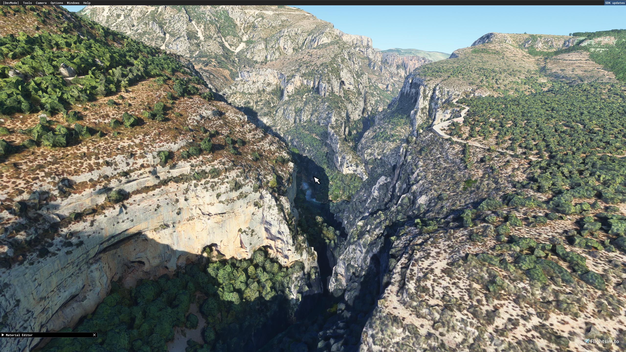
The Verdon gorges (light - full)
The Verdon gorges, Verdon canyon or Grand Canyon are a set of gorges in France located in Provence, between the Alpes-de-Haute-Provence and the Var. Carved by the Verdon in the middle of its course, they separate the Préalpes de Castellane to the south from the Préalpes de Digne to the north, forming a narrow valley 25 kilometers long and reaching up to 700 meters deep.

User Reviews
3 reviews
Location
More Information
Version History
No version history available.
Related

Swiss mountains tree fix (trees on mountains removed)
A comprehensive mod fixing tree placement on Swiss mountains, particularly removing inaccurately placed trees on mountain peaks. The update includes a shift to more realistic conifer trees in the Alps and an expansion to border areas of France, Italy, and Austria. From Alpstein Säntis to Stockhorn, numerous locations across Switzerland have been meticulously corrected for a more authentic flight experience.
by THEOLI4D

Shorter Trees / Tree Height Modification VERSION 4.0 for MFS2020 (shorter, realistic trees)
Experience realistic and shorter trees in Microsoft Flight Simulator with the Shorter Trees / Tree Height Modification VERSION 4.0 add-on. Compatible with the latest version of MSFS, this mod provides adjusted tree heights for a more authentic flying experience. Update includes enhanced tree coloration blending seamlessly with photogrammetry trees. Installation is simple - just copy the folder into your community folder and enjoy a new perspective from the skies.
by ARIF STUDIOS - Adnan Arif

AUSTRIA 10m DEM - High Resolution Terrain Elevation Data from LIDAR Imaging
Explore the stunning terrain of Austria with this mod featuring high-resolution LIDAR data, offering a mesh resolution of 10m for a more realistic flight experience. Flatten lakes, rivers, and eliminate any terrain artifacts as you soar over the Austrian landscape. Divided into regions for convenience and performance optimization, this mod enhances the mountain shapes to mirror reality and provides a smoother flying experience. Experience Austria like never before with enhanced elevation data and realistic terrains.
by Troglodytus

SWITZERLAND 20m DEM - High Resolution Terrain Elevation Data from LIDAR Imaging
Explore the beauty of Switzerland with this mod offering high resolution terrain elevation data using LIDAR imaging. The mesh resolution is 20m, providing exceptional detail with a height resolution of 0.1m. Update includes extreme LIDAR meshes for specific regions. Please note potential performance impacts and report any bugs for further improvements. Fly VFR over Switzerland with enhanced realism and accuracy.
by Troglodytus
about 2 years ago
c'est ok, j'ai tout installé, magnifique !
Encore merci pour ton très beau travail, je connais un peu cette région bien que je vole plus souvent dans mon aéroclub sur la Gironde ...
Bonne continuation dans tes futurs projets pour la simulation !