Description
Version 1.2
Recompiled due to error with Sim Update 12 and the sandbanks not showing. This should fix it but there may still be the odd missing scenery tile that refuses to load occasionally. This has appeared since the last MSFS update but seems to be random with Bing imagery which makes me think it is an issue on the Bing server side. Hopefully this will get fixed by Microsoft.
Version 1.1
Extended coverage from Barrow-in-Furness up to Bowness-on-Solway
Version 1.0
Initial release
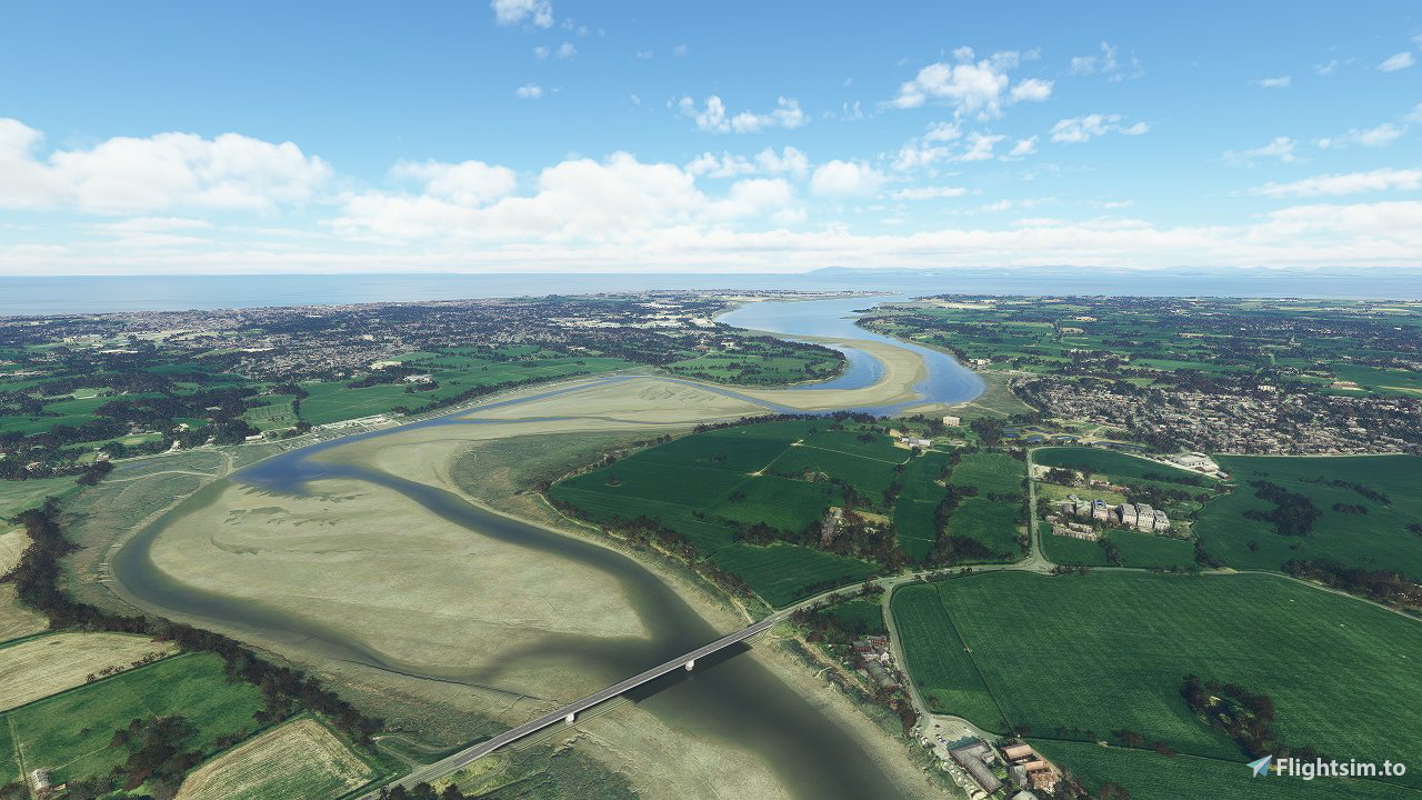
This is my second scenery modification to make the Sandbanks visible along UK beaches during low tide. This one covers the North West coast from Fleetwood up to Barrow-in-Furness.
Please note this is not perfect yet and may be updated further but currently shows a nice representation of the sandbanks at low tide where the Bing maps imagery allows.
Screeenshots are taken with ORBX Great Britain Central installed but this mod should work fine if you dont have ORBX.
For installation extract the included folder called " nw-sandbanks 1" into your MSFS Community folder.
Check out my other sandbank mods here: https://flightsim.to/profile/mgk07/uploads
Other areas may be covered in the future when time allows :)
Thanks,
Mark.
Comments(10)
Log in to join the discussion
Log Inabout 3 years ago
Hi, it seems it was broken! I've just recompiled and re uploaded which hopefully should fix it. I'll test all my other sandbank mods as well and update when I get the chance. Thanks for the heads up.
about 4 years ago
thanks for your efforts. really good mod that enhances the scenery quite alot
over 4 years ago
Fantastic work. Thank you. Your focus will surely be on the UK for now. However, I would be very happy if you would someday find the time and the mood to also enhance the East Frisian Islands (Germany) with such beautiful sandbanks.
Best regards
Daniel
over 4 years ago
Hi Daniel, thanks for your kind words. Noted your request and will take a look to see what's possible :)
over 4 years ago
Thank You! 😉
over 4 years ago
I’ve just uploaded the East Frisian Islands. It’s not perfect as the Bing images are patchy but see what you think :).
over 4 years ago
The sand banks add tremendously to the experience of flying in the coverage area. This mod once again proves that mother nature is the best abstract artist. Thank you for sharing her work with us! Very, very highly recommended!!!
over 4 years ago
Mark, thank you so much for doing this, an absolute transformation. It now looks like it should on low tide. Far more interesting than the default coasts :)
over 4 years ago
Fantastic ! Thank You
North West England Sandbanks
Explore the North West England Sandbanks add-on, enhancing the MSFS scenery from Fleetwood to Barrow-in-Furness. Witness the realistic representation of sandbanks during low tide, with extended coverage up to Bowness-on-Solway. Stay tuned for potential updates to further improve this scenery modification by Mark.

User Reviews
5 reviews
Location
More Information
Version History
Version 1.2 Recompiled due to error with Sim Update 12 and the sandbanks not showing. This should fix it but there may still be the odd missing scenery tile that refuses to load occasionally. This has appeared since the last MSFS update but seems to be random with Bing imagery which makes me think it is an issue on the Bing server side. Hopefully this will get fixed by Microsoft.
Related

Swiss mountains tree fix (trees on mountains removed)
A comprehensive mod fixing tree placement on Swiss mountains, particularly removing inaccurately placed trees on mountain peaks. The update includes a shift to more realistic conifer trees in the Alps and an expansion to border areas of France, Italy, and Austria. From Alpstein Säntis to Stockhorn, numerous locations across Switzerland have been meticulously corrected for a more authentic flight experience.
by THEOLI4D

Shorter Trees / Tree Height Modification VERSION 4.0 for MFS2020 (shorter, realistic trees)
Experience realistic and shorter trees in Microsoft Flight Simulator with the Shorter Trees / Tree Height Modification VERSION 4.0 add-on. Compatible with the latest version of MSFS, this mod provides adjusted tree heights for a more authentic flying experience. Update includes enhanced tree coloration blending seamlessly with photogrammetry trees. Installation is simple - just copy the folder into your community folder and enjoy a new perspective from the skies.
by ARIF STUDIOS - Adnan Arif

AUSTRIA 10m DEM - High Resolution Terrain Elevation Data from LIDAR Imaging
Explore the stunning terrain of Austria with this mod featuring high-resolution LIDAR data, offering a mesh resolution of 10m for a more realistic flight experience. Flatten lakes, rivers, and eliminate any terrain artifacts as you soar over the Austrian landscape. Divided into regions for convenience and performance optimization, this mod enhances the mountain shapes to mirror reality and provides a smoother flying experience. Experience Austria like never before with enhanced elevation data and realistic terrains.
by Troglodytus

SWITZERLAND 20m DEM - High Resolution Terrain Elevation Data from LIDAR Imaging
Explore the beauty of Switzerland with this mod offering high resolution terrain elevation data using LIDAR imaging. The mesh resolution is 20m, providing exceptional detail with a height resolution of 0.1m. Update includes extreme LIDAR meshes for specific regions. Please note potential performance impacts and report any bugs for further improvements. Fly VFR over Switzerland with enhanced realism and accuracy.
by Troglodytus
over 3 years ago
This hasn't been broken by a recent update, has it? Was flying over the Fylde coast at 10K and couldn't see the sandbanks.