Description
La Jolla, CA Coastal Enhancements
The default scenery for the La Jolla coast has excessive and overgrown trees and bushes, cliffs have excess vegetation and roads are filled with trees. In addition, Photogrammetry turns palm trees into strange obelisks.
This scenery enhancement does the following:
- updates the Biome to reflect the natural look of the area
- reduces and resizes existing trees and bushes
- removes vegetation from cliffsides
- removes trees from major roads
- uncovers parking lots from excess trees
- removes PG (Photogrammetry) palm trees and other objects throughout
- adds palm trees in various locations
Version 2.0
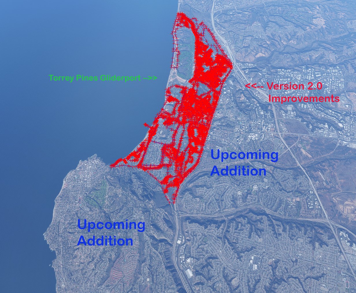
Adds the University of California San Diego, La Jolla Village and the remainder of Torrey Pines east to Interstate 5.
Note : This mod improves the trees on the University of California San Diego campus. Another freeware mod on this site removes all trees and vegetation from UCSD. Due to the overlap, if you use the other mod, you will see NO TREES on UCSD. There is no way for me to add those trees back.
Version 1.2
Compiled to work with Sim Update 7.
Version 1.1
Adds the area from the Torrey Pines Gliderport north to the Torrey Pines State Reserve, west of N Torrey Pines Road. Compiled to comply with Sim Update 6.
Version 1.0
Enhances the La Jolla coast from the Torrey Pines Gliderport south to the La Jolla Beach & Tennis Club, west of N Torrey Pines Road and Torrey Pines Road. Adds water mask for Scripps Pier. Adds palm trees to mansions along La Jolla Farms and the beach at La Jolla Shores.
Later versions will extend the scenery south to Bird Rock and east to Interstate 5.
Whether you are flying low and slow along the coast or departing or approaching Montgomery Field or KSAN, this scenery mod should improve the view!
Integrates with the Torrey Pines Gliderport.
Download and unzip, placing the resulting folder into your community folder.
Comments(4)
Log in to join the discussion
Log Inover 4 years ago
The current plan is to add everything west of Interstate 5, including the majority of UCSD. Although that will come a little later, since the next major update will continue down the La Jolla coast to the Cove and Windansea Beach.
As for the rest of UCSD and other residential areas, they would be included in a different project, including the Golden Triangle area.
Thanks for your interest!
over 4 years ago
Cool thanks! will keep an eye out for updates!
over 4 years ago
Outstanding job! Divebombing down Nautilus and Via Capri never looked so good!
La Jolla, CA Coastal Enhancements
Enhance your flying experience along the La Jolla, CA coast with this scenery mod. Update the biome, resize trees, remove vegetation, and add palm trees to create a more natural and realistic environment. Version 2.0 includes UC San Diego and other locations, while version 1.2 is compatible with Sim Update 7. Perfect for low flights or approaching nearby airports, this mod improves the scenic views along the coastline.

Location
More Information
Version History
Adds the University of California San Diego, La Jolla Village and the remainder of Torrey Pines east to Interstate 5.
Related

Swiss mountains tree fix (trees on mountains removed)
A comprehensive mod fixing tree placement on Swiss mountains, particularly removing inaccurately placed trees on mountain peaks. The update includes a shift to more realistic conifer trees in the Alps and an expansion to border areas of France, Italy, and Austria. From Alpstein Säntis to Stockhorn, numerous locations across Switzerland have been meticulously corrected for a more authentic flight experience.
by THEOLI4D

Shorter Trees / Tree Height Modification VERSION 4.0 for MFS2020 (shorter, realistic trees)
Experience realistic and shorter trees in Microsoft Flight Simulator with the Shorter Trees / Tree Height Modification VERSION 4.0 add-on. Compatible with the latest version of MSFS, this mod provides adjusted tree heights for a more authentic flying experience. Update includes enhanced tree coloration blending seamlessly with photogrammetry trees. Installation is simple - just copy the folder into your community folder and enjoy a new perspective from the skies.
by ARIF STUDIOS - Adnan Arif

AUSTRIA 10m DEM - High Resolution Terrain Elevation Data from LIDAR Imaging
Explore the stunning terrain of Austria with this mod featuring high-resolution LIDAR data, offering a mesh resolution of 10m for a more realistic flight experience. Flatten lakes, rivers, and eliminate any terrain artifacts as you soar over the Austrian landscape. Divided into regions for convenience and performance optimization, this mod enhances the mountain shapes to mirror reality and provides a smoother flying experience. Experience Austria like never before with enhanced elevation data and realistic terrains.
by Troglodytus

SWITZERLAND 20m DEM - High Resolution Terrain Elevation Data from LIDAR Imaging
Explore the beauty of Switzerland with this mod offering high resolution terrain elevation data using LIDAR imaging. The mesh resolution is 20m, providing exceptional detail with a height resolution of 0.1m. Update includes extreme LIDAR meshes for specific regions. Please note potential performance impacts and report any bugs for further improvements. Fly VFR over Switzerland with enhanced realism and accuracy.
by Troglodytus
over 4 years ago
Thanks so much for this! Does this include the UCSD area and the residential area east of UCSD? If not I really look forward to this being added if its not too much trouble!! thanks again