Description
French Alps - Department of Haute-Savoie (74) 1.0.0
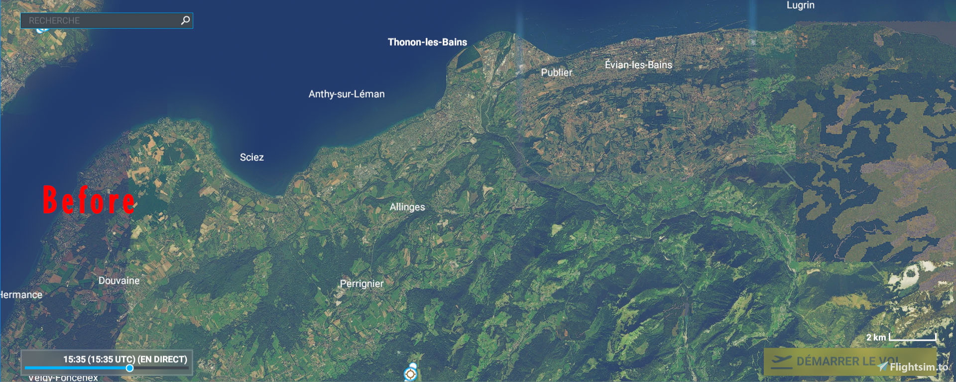
Since the MSFS BingMap imagery is of poor quality, or even replaced by generic textures on some mountain ranges in the Haute-Savoie department (74), this supplement, produced with the source of the BD ORTHO® OpenData aerial photographs from IGN allows to correct this problem very advantageously. The resolution is 2.39 m (Lod16) on all the massifs benefiting from this patch.
With this last part, the correction of the photo coverage of the departments of Savoie (73) and Haute-Savoie (74) ends.
To follow in a few weeks the correction of the department of Isère (38).
Installation: extract then copy and paste in your "Community" directory
Thanks to:
Microsoft
Asobo
MSFS Toolkit by Nool Aerosystems
Copyright: ftsxlw
ftsx.free.lw@gmail.com
Exclusively for free distribution and subject to the express authorization of the author.
Alpes Française - Département de Haute-Savoie (74) 1.0.0
L'imagerie BingMap de MSFS étant de mauvaise qualité, voire remplacé par des textures génériques sur quelques massifs montagneux du département de Haute-Savoie (74), ce complément, réalisé avec la source des photographies aériennes BD ORTHO® OpenData de l'IGN permet de corriger très avantageusement ce problème. La résolution est de 2.39 m (Lod16) sur tous les massifs bénéficiant de ce correctif.
Avec cette dernière partie se termine la correction de la couverture photo des départements de la Savoie (73) et de la Haute-Savoie (74).
À suivre dans quelques semaines la correction du département de l'Isère (38).
https://fr.wikipedia.org/wiki/Haute-Savoie
Installation : extraire puis copier-coller dans votre répertoire « Community »
Merci à:
Microsoft
Asobo
MSFS Toolkit by Nool Aerosystems
Copyright : ftsxlw
ftsx.free.lw@gmail.com
Exclusivement pour diffusion gratuite et soumise à autorisation expresse de l’auteur.
Comments(15)
Log in to join the discussion
Log Inalmost 4 years ago
Bonjour,
Je viens de retester et tous mes scenery sont bien compatibles et visibles.
Peut-être une piste pour vous, supprimer le content.xml avant de lancer MSFS, celui-ci va ensuite se régénérer et réorganiser vos add-ons, voici ci-dessous l'explication pour l'installation MSFS du Windows Store.
The "content.xml" can be found for the Windows store version in
C:\Users\*****\AppData\Local\Packages\Microsoft.FlightSimulator_8wekyb3d8bbwe\LocalCache
almost 5 years ago
est-ce compatible (ou remplace) les aravis ?
almost 5 years ago
C'est un complément des Aravis donc oui compatible.
almost 5 years ago
Bonjour!
Super travail, merci! Quel logiciel utilisez-vous pour le mesh IGN? Je m'initie à la scenery, j'utilise ortho4xp mais que pour la partie imagerie.
almost 5 years ago
Bonsoir,
Je n'ai pas touché au mesh de MSFS car celui-ci est déja celui de l'IGN, le BD Alti qui à une précision de 1 m.
almost 5 years ago
D'accord, merci beaucoup :)
almost 5 years ago
Merci beaucoup. Votre travail est remarquable
almost 5 years ago
Merci beaucoup. Superbe travail. J'attends l'Isère avec impatience...
almost 5 years ago
Si vous voulez un programme de travail :
Vosges, Bretagne ,Pyrénées, Massif Central, cela fera 65 Go de données ... et quelques heures, enfin beaucoup d'heures, de travail😂
almost 5 years ago
Bonjour. Je découvre avec bonheur que vous tenez promesse en poursuivant vos travaux dans ma région natale....magnifique soyons chauvin et magnifiquement reproduite. Viendra la Chartreuse, le Vercors et Belledonne peut-être
almost 5 years ago
Well, that is a wonderful useful work !
It changes everything when flying VFR...
EUH ! could you do that for the whole world please😉
almost 5 years ago
Thank you...I would need magic potion or that the clouds no longer exist when the bingmap satellites make their pictures. But, a chance for France with the planes of the IGN and the Open-Data.
almost 5 years ago
Super idée et beau travail...Pourriez vous envisager un travail identique pour le luchonnais dans les pyrénées où tous les 3000 sont en textures basiques...tout comme les Ecrins de leur côté d'ailleurs ?? Merci de votre attention.
almost 5 years ago
Merci, je vais rajouter cela à ma liste des "choses à faire".
French Alps - Department of Haute-Savoie (74) 1.0.0 (4)
Enhance your Microsoft Flight Simulator experience with the French Alps - Department of Haute-Savoie add-on, which corrects the poor quality BingMap imagery in the Haute-Savoie department using BD ORTHO® OpenData aerial photographs from IGN. Enjoy improved resolution of 2.39 m (Lod16) on all mountain ranges covered by this patch, with upcoming corrections for neighboring departments. Simply extract and paste the files into your "Community" directory to enjoy this free distribution add-on.
User Reviews
1 reviews
Location
More Information
Version History
No version history available.
Related

Swiss mountains tree fix (trees on mountains removed)
A comprehensive mod fixing tree placement on Swiss mountains, particularly removing inaccurately placed trees on mountain peaks. The update includes a shift to more realistic conifer trees in the Alps and an expansion to border areas of France, Italy, and Austria. From Alpstein Säntis to Stockhorn, numerous locations across Switzerland have been meticulously corrected for a more authentic flight experience.
by THEOLI4D

Shorter Trees / Tree Height Modification VERSION 4.0 for MFS2020 (shorter, realistic trees)
Experience realistic and shorter trees in Microsoft Flight Simulator with the Shorter Trees / Tree Height Modification VERSION 4.0 add-on. Compatible with the latest version of MSFS, this mod provides adjusted tree heights for a more authentic flying experience. Update includes enhanced tree coloration blending seamlessly with photogrammetry trees. Installation is simple - just copy the folder into your community folder and enjoy a new perspective from the skies.
by ARIF STUDIOS - Adnan Arif

AUSTRIA 10m DEM - High Resolution Terrain Elevation Data from LIDAR Imaging
Explore the stunning terrain of Austria with this mod featuring high-resolution LIDAR data, offering a mesh resolution of 10m for a more realistic flight experience. Flatten lakes, rivers, and eliminate any terrain artifacts as you soar over the Austrian landscape. Divided into regions for convenience and performance optimization, this mod enhances the mountain shapes to mirror reality and provides a smoother flying experience. Experience Austria like never before with enhanced elevation data and realistic terrains.
by Troglodytus

SWITZERLAND 20m DEM - High Resolution Terrain Elevation Data from LIDAR Imaging
Explore the beauty of Switzerland with this mod offering high resolution terrain elevation data using LIDAR imaging. The mesh resolution is 20m, providing exceptional detail with a height resolution of 0.1m. Update includes extreme LIDAR meshes for specific regions. Please note potential performance impacts and report any bugs for further improvements. Fly VFR over Switzerland with enhanced realism and accuracy.
by Troglodytus
almost 4 years ago
Bonjour j'ai installé tous les fichiers dans le community et malheureusement aucun changement j'ai toujours les meme paysages est ce que les fichiers sont toujours compatibles avec les dernieres updates du simu ?