Description
Mountain range of ARAVIS 1.0.0 - French Alpes
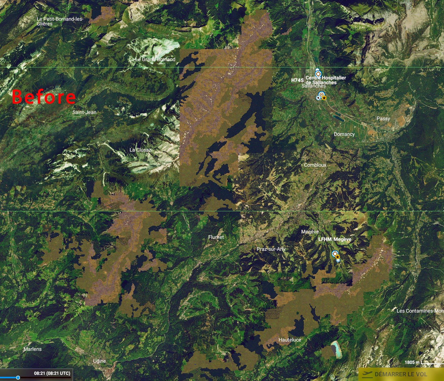
Since MSFS's BingMap imagery is of poor quality, or even replaced by generic textures on the Aravis Massif, this supplement, produced with the source of the BD ORTHO® OpenData from IGN, makes it possible to visualize the Aravis Massif and a little at of the. The resolution is 2.39 m (Lod16). Other places in Haute-Savoie and Savoie will also be improved in the coming weeks.
https://fr.wikipedia.org/wiki/Cha%C3%AEne_des_Aravis
Installation: extract then copy and paste in your "Community" directory
if you are not familiar with using multiple decompressions and since FlightSim.to also adds characters to the names of .RAR files you must remove these extra characters for the decompression to be automatic !
For example, for the first file, its name is "france-dpt-74 xxxxxx 1.0.0.part1.RAR" and FlightSim.to add "france-dpt-74 xxxxxx 1.0.0.part1_emQuK.RAR", so you need to remove everything after the _ so that Winrar finds his marbles !
Thanks to:
Microsoft
Asobo
MSFS Toolkit by Nool Aerosystems
Copyright: ftsxlw
ftsx.free.lw@gmail.com
Exclusively for free distribution and subject to the express authorization of the author.
Massif des ARAVIS 1.0.0 - Alpes Française
L'imagerie BingMap de MSFS étant de mauvaise qualité, voire remplacé par des textures génériques sur le Massif des Aravis, ce complément réalisé avec la source des photographies aériennes BD ORTHO® OpenData de l'IGN permet de visualiser le Massif des Aravis et un peu au dela. La résolution est de 2.39 m (Lod16). D'autres endroits de la Haute-Savoie et de la Savoie seront également amélioré dans les semaines prochaines.
https://fr.wikipedia.org/wiki/Cha%C3%AEne_des_Aravis
Installation : extraire puis copier-coller dans votre répertoire « Community »
Si vous n'êtes pas familier avec l'utilisation des décompressions multiples et comme FlightSim.to ajoute des caractères aux noms des fichiers .RAR, vous devez supprimer ces caractères supplémentaires pour que la décompression soit automatique !
Par exemple, pour le premier fichier, son nom originel est, "france-dpt-74 xxxxx1.0.0.part1.RAR" mais FlightSim.to ajoute "france-dpt-74 xxxxx1.0.0.part1_emQuK.RAR", vous devez donc supprimer tout ce qui est après le _ pour que Winrar retrouve ses billes !
Merci à:
Microsoft
Asobo
MSFS Toolkit by Nool Aerosystems
Copyright : ftsxlw
ftsx.free.lw@gmail.com
Exclusivement pour diffusion gratuite et soumise à autorisation expresse de l’auteur.
Comments(39)
Log in to join the discussion
Log Inabout 11 hours ago
almost 2 years ago
Si je comprends bien, il y a plusieurs fichiers pour cette réalisation mais je n'en trouve qu'un. Où sont les autres ?
Merci.
about 2 years ago
over 2 years ago
over 2 years ago
De mon côté, la décompression fonctionne toujours, les fichiers ne sont pas corrompus. Lisez bien les conseils pour la décompression des fichiers .RAR multiples.
about 2 years ago
J ai téléchargé win rar , j'ai viré les extensions de fichier à partir de : " _ " pour les 4 fichiers et en décompressant le 1 er il a tout décompresser ! Magnifique je connaissais pas !
Merci pour ce joli travail !!
j'invite tous les amoureux du vol en montagne à le télécharger !!!
almost 3 years ago
almost 3 years ago
almost 3 years ago
over 4 years ago
Hello, who can help me? After the correct extraction by winRar I get six files to save in "community": france-dpt-74-les-aravis-lod-16-01, ...02, ...02b, ...03, ...04 and ...05. Every file has three dates - CGL, manifest and layout (no content-info?). But there's no change of the bing-mesh, when I fly other there. When I compare these files with others, I think, they are not complet or damaged. I hope, someone can help me, because I think, that these landscape-addon is a very good possibility to chance the bad Bing-dates... Thank you!
over 4 years ago
IDEM.
over 4 years ago
Problème résolut. Décompresser uniquement dans "Comunnity" le fichier "france -dept-74-les-aravis-1.0.0part1". (france-dept-74-les-aravis-lod16-01; lod16-02; lod16-02b; lod16-03; lod16-04 et lod16-05.)
Bon vol! et Très bon travail. Merci
almost 3 years ago
over 4 years ago
Bonjour,
J'ai un petit soucis de décompression, il semble que les fichiers soient corrompus
merci
almost 5 years ago
Excellent work. Can you realize the Chamonix valley from Aravis to Verte Needle and the Red Needles ?
almost 5 years ago
I keep getting errors when extracting the content on all archives of this mod. Rest of mods work.
almost 5 years ago
if you are not familiar with using multiple decompressions and since FlightSim.to also adds characters to the names of .RAR files you must remove these extra characters for the decompression to be automatic !
For example, for the first file, its name is "france-dpt-74 xxxxxx 1.0.0.part1.RAR" and FlightSim.to add "france-dpt-74 xxxxxx 1.0.0.part1_emQuK.RAR", so you need to remove everything after the _ so that Winrar finds his marbles !
almost 5 years ago
Ah... got it! Thanks. Sorry for not reading. I wasn't expecting that. It's OK. I'm old enough to understand it :) .
almost 5 years ago
Même si j'ai déjà pulié un commentaire il y a 7 jours mais je n'avais pas encore testé cette scène, je reviens faire part à ftsxfreelw de ma très grande satisfaction pour l'embellissement de ce secteur. Mis à part quelques ajustements de l'image somme toute non gênants, comme d'autres j'attendrai la poursuite de vos réalisations et encore merci.
Mountain range of ARAVIS 1.0.0, French Alpes / Massif des ARAVIS 1.0.0 - Alpes Française (1)
Explore the enhanced visuals of the Aravis Massif in the French Alps with this add-on created using BD ORTHO® OpenData imagery. Enjoy improved details at a resolution of 2.39 m (Lod16) and anticipate future enhancements in Haute-Savoie and Savoie. Simply extract and add to your "Community" directory for a more immersive flight experience.
User Reviews
7 reviews
Location
More Information
Version History
No version history available.
Related

Swiss mountains tree fix (trees on mountains removed)
A comprehensive mod fixing tree placement on Swiss mountains, particularly removing inaccurately placed trees on mountain peaks. The update includes a shift to more realistic conifer trees in the Alps and an expansion to border areas of France, Italy, and Austria. From Alpstein Säntis to Stockhorn, numerous locations across Switzerland have been meticulously corrected for a more authentic flight experience.
by THEOLI4D

Shorter Trees / Tree Height Modification VERSION 4.0 for MFS2020 (shorter, realistic trees)
Experience realistic and shorter trees in Microsoft Flight Simulator with the Shorter Trees / Tree Height Modification VERSION 4.0 add-on. Compatible with the latest version of MSFS, this mod provides adjusted tree heights for a more authentic flying experience. Update includes enhanced tree coloration blending seamlessly with photogrammetry trees. Installation is simple - just copy the folder into your community folder and enjoy a new perspective from the skies.
by ARIF STUDIOS - Adnan Arif

AUSTRIA 10m DEM - High Resolution Terrain Elevation Data from LIDAR Imaging
Explore the stunning terrain of Austria with this mod featuring high-resolution LIDAR data, offering a mesh resolution of 10m for a more realistic flight experience. Flatten lakes, rivers, and eliminate any terrain artifacts as you soar over the Austrian landscape. Divided into regions for convenience and performance optimization, this mod enhances the mountain shapes to mirror reality and provides a smoother flying experience. Experience Austria like never before with enhanced elevation data and realistic terrains.
by Troglodytus

SWITZERLAND 20m DEM - High Resolution Terrain Elevation Data from LIDAR Imaging
Explore the beauty of Switzerland with this mod offering high resolution terrain elevation data using LIDAR imaging. The mesh resolution is 20m, providing exceptional detail with a height resolution of 0.1m. Update includes extreme LIDAR meshes for specific regions. Please note potential performance impacts and report any bugs for further improvements. Fly VFR over Switzerland with enhanced realism and accuracy.
by Troglodytus
1 day ago