Description
- Introduction
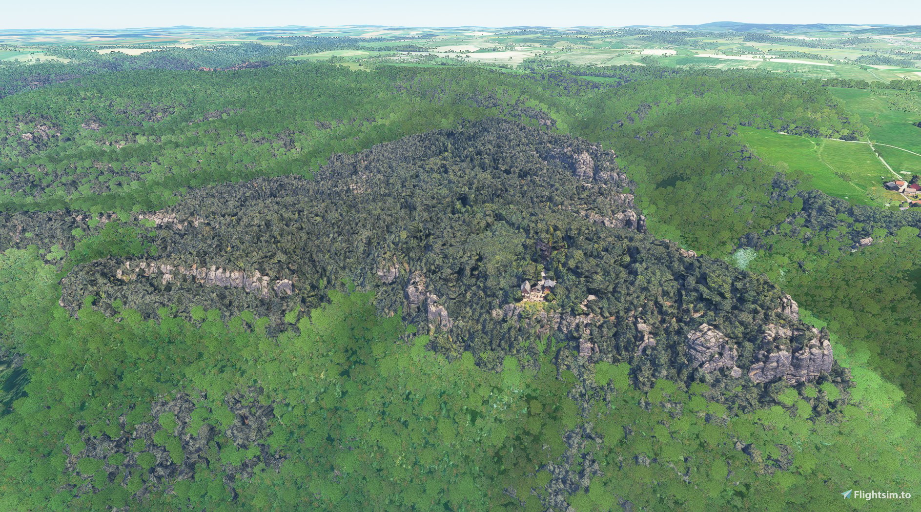
The Elbe Sandstone Mountains, better known as Saxon Switzerland, are probably the most imposing rocky mountains in Germany outside the Alps. Since the original Bing sceneries unfortunately only show green hills instead of steep rocks and the interest in this landscape is high, therefore this add-on. The scenery is northeast of Rathen and includes the town of Hohnstein, the village of Waitzdorf and the rocky areas Brand and Ochel.
The sceneries were created from Google Maps using the Google Earth Decoder.
- Content
. Brand – LOD 17-19 (GPS: 50.9669975, 14.10566363)
- Installation instructions
. Extract the archives in the community folder
- Credits / copyright
This scenery has been extracted from Google Maps, hence all 3D credits goes to Google.
This scenery has been generated with the Google Earth Decoder tool (credits to /u/Jonahex111):
https://www.reddit.com/r/FS2020Creation/comments/j3faaj/google_earth_decoder_now_userfriendly/
- On their own behalf
Since I am still a beginner despite many attempts and hours on the PC, constructive criticism, relevant tips and suggestions are welcome.
Comments(3)
Log in to join the discussion
Log Inover 4 years ago
The zip file with "V2" contains the newer version. I also don't know how the version information in FlightSim.to comes about.
over 4 years ago
Thanks for the reply. Here it is easy, because there is just one old file and the new one. Some other Saxon Switzeland sceneries with more than one file are a bit more problematic. It's hard to exactly know which files to install. Maybe you could add that into the description. Anyway, thanks for the great eye candy!
Saxon Switzerland - Brand-Ochel
Discover the breathtaking beauty of the Elbe Sandstone Mountains in Germany with the Saxon Switzerland - Brand-Ochel add-on. Explore the rocky landscapes of Brand and Ochel, created using Google Maps and the Google Earth Decoder tool. Immerse yourself in this stunning scenery located northeast of Rathen, including the town of Hohnstein and the village of Waitzdorf. Share feedback to support the continuous improvement of this immersive flight sim experience.

Location
More Information
Version History
- Notes / changes compared to version 3 . the large number of scenery texture files was reduced according to the instructions and with the support of Kevair with ModelConverterX => shorter loading times of the textures
Related

Swiss mountains tree fix (trees on mountains removed)
A comprehensive mod fixing tree placement on Swiss mountains, particularly removing inaccurately placed trees on mountain peaks. The update includes a shift to more realistic conifer trees in the Alps and an expansion to border areas of France, Italy, and Austria. From Alpstein Säntis to Stockhorn, numerous locations across Switzerland have been meticulously corrected for a more authentic flight experience.
by THEOLI4D

Shorter Trees / Tree Height Modification VERSION 4.0 for MFS2020 (shorter, realistic trees)
Experience realistic and shorter trees in Microsoft Flight Simulator with the Shorter Trees / Tree Height Modification VERSION 4.0 add-on. Compatible with the latest version of MSFS, this mod provides adjusted tree heights for a more authentic flying experience. Update includes enhanced tree coloration blending seamlessly with photogrammetry trees. Installation is simple - just copy the folder into your community folder and enjoy a new perspective from the skies.
by ARIF STUDIOS - Adnan Arif

AUSTRIA 10m DEM - High Resolution Terrain Elevation Data from LIDAR Imaging
Explore the stunning terrain of Austria with this mod featuring high-resolution LIDAR data, offering a mesh resolution of 10m for a more realistic flight experience. Flatten lakes, rivers, and eliminate any terrain artifacts as you soar over the Austrian landscape. Divided into regions for convenience and performance optimization, this mod enhances the mountain shapes to mirror reality and provides a smoother flying experience. Experience Austria like never before with enhanced elevation data and realistic terrains.
by Troglodytus

SWITZERLAND 20m DEM - High Resolution Terrain Elevation Data from LIDAR Imaging
Explore the beauty of Switzerland with this mod offering high resolution terrain elevation data using LIDAR imaging. The mesh resolution is 20m, providing exceptional detail with a height resolution of 0.1m. Update includes extreme LIDAR meshes for specific regions. Please note potential performance impacts and report any bugs for further improvements. Fly VFR over Switzerland with enhanced realism and accuracy.
by Troglodytus
over 4 years ago
Hello,
here I also have a problem. There are two files to download, the "Main File" after clicking on download "ESG_Brand_Gk_sIxYf" says version 2.0, but it seems to be version 1.0. I assume the new file is the one with V2 in the filename "ESG_Brand-V2_Gk_I3wCb.zip"? Here flightsim.to says it's version 1.0.
Can you check, please? Thanks.