
Description
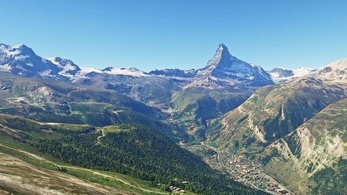
Titlis is a mountain of the Uri Alps, located on the border between the cantons of Obwalden and Bern. At 3238 metres above sea level. It is mainly accessed from Engelberg (OW) on the north side and is famous as the site of the world's first rotating cable car. The cable car system connects Engelberg (996 m) to the summit of Klein Titlis (3028 m) through the three stages of Gerschnialp (1262 m), Trübsee (1796 m) and Stand (2428 m).
The last part of cable car leads above the glacier. At Klein Titlis, it is possible to visit an illuminated glacier cave from an entrance within the cable-car station, which also includes shops and restaurants. The Titlis Cliff Walk, the highest elevation suspension bridge in Europe, opened in December 2012, giving views across the Alps.
Credits:
This scenery has been extracted from Google Maps, hence all 3D credits goes to Google.
This scenery has been generated with the Google Earth Decoder tool (credits to /u/Jonahex111):
https://www.reddit.com/r/FS2020Creation/comments/j3faaj/google_earth_decoder_now_userfriendly/
Installation:
Extract and move Titlis to the Community folder. Don't forget to restart the MSFS 2020 after that. Thats it!
Comments(3)
Log in to join the discussion
Log Inabout 5 years ago
Beautiful, many thanks. Glad to see it works with the 20m Switzerland DEM also. There is a bit of a blending problem below the vertical face, might this be fixable? Any chance of doing the surrounding areas of Trübsee and Engelberg as well?
about 5 years ago
Thank you musician262. It is my first scenery and I still need some practice with handling the polygons. It is easier to work with a smaller amount of data, but I'm happy to have your comments.
Titlis
Explore the breathtaking mountain of Titlis in the Uri Alps with this add-on. Experience the worlds first rotating cable car, illuminated glacier cave, and the highest elevation suspension bridge in Europe. Simply extract the files to your Community folder and start your adventure in Microsoft Flight Simulator 2020.

User Reviews
2 reviews
Location
More Information
Version History
No version history available.
Related
Matterhorn Mountain
Explore the stunning beauty of Matterhorn mountain with this add-on, featuring a fully photogrammetry-based model and terraformed edges for a more realistic experience. Version 2.0 includes new additions such as improved LOD levels, color-corrected textures, cable car pylons, and populated forests. Install by dragging the folder into your "Community" folder and enjoy the enhanced scenery around this iconic peak.
by NikPrist
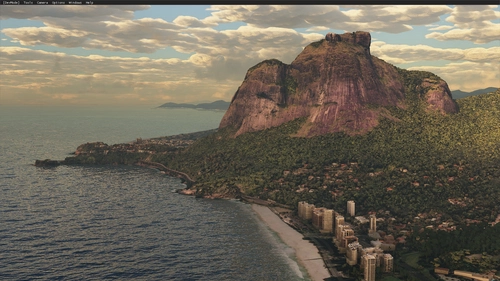
Rio de Janeiro Megapack Montanhas
Explore the detailed mountainous landscape of Rio de Janeiro in this updated megapack. Precisely positioned mountains like Pedra da Gávea and Pão de Açúcar using Google Maps models. Create your mod via Earth2MSFS for an effective import process. Stay tuned for further updates with optimized textures and added landmarks. Individualize your experience by adding specific mountain ranges to enhance your simulation.
by RodrigoMoraes94
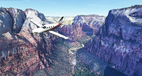
Zion Canyon National Park, Utah
Explore the breathtaking beauty of Zion Canyon National Park in Utah with this V1.0 scenery add-on. Discover well-known locations like the Zion Canyon Overlook, Angels Landing, and more. Experience corrected terrain heights and improved color blending for a more immersive flight simulation. Simply extract the file to your Community Folder and start your aerial adventure in this stunning national park.
by Jeppeson2001
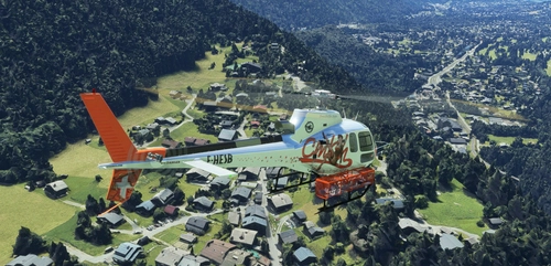
Chamonix-Mont-Blanc, Rhône-Alpes, France - Valley
Explore the stunning Chamonix-Mont-Blanc valley in Rhône-Alpes, France with this addon, including a semi-fictional DZ at Argentière. Enhance your experience by combining it with the Mountains addon. Download, extract into community folder, and enjoy photogrammetry and object data. This addon requires a minimum configuration for optimal performance.
by AdrianL
over 2 years ago
Schon auf den Fotos sind nur Klötze zu sehen.
Die Allgemeine Bewertung hat mich zum herunterladen bewogen, wird aber wieder entfernt.
Ulrich57