Description
Experience the Canary Islands
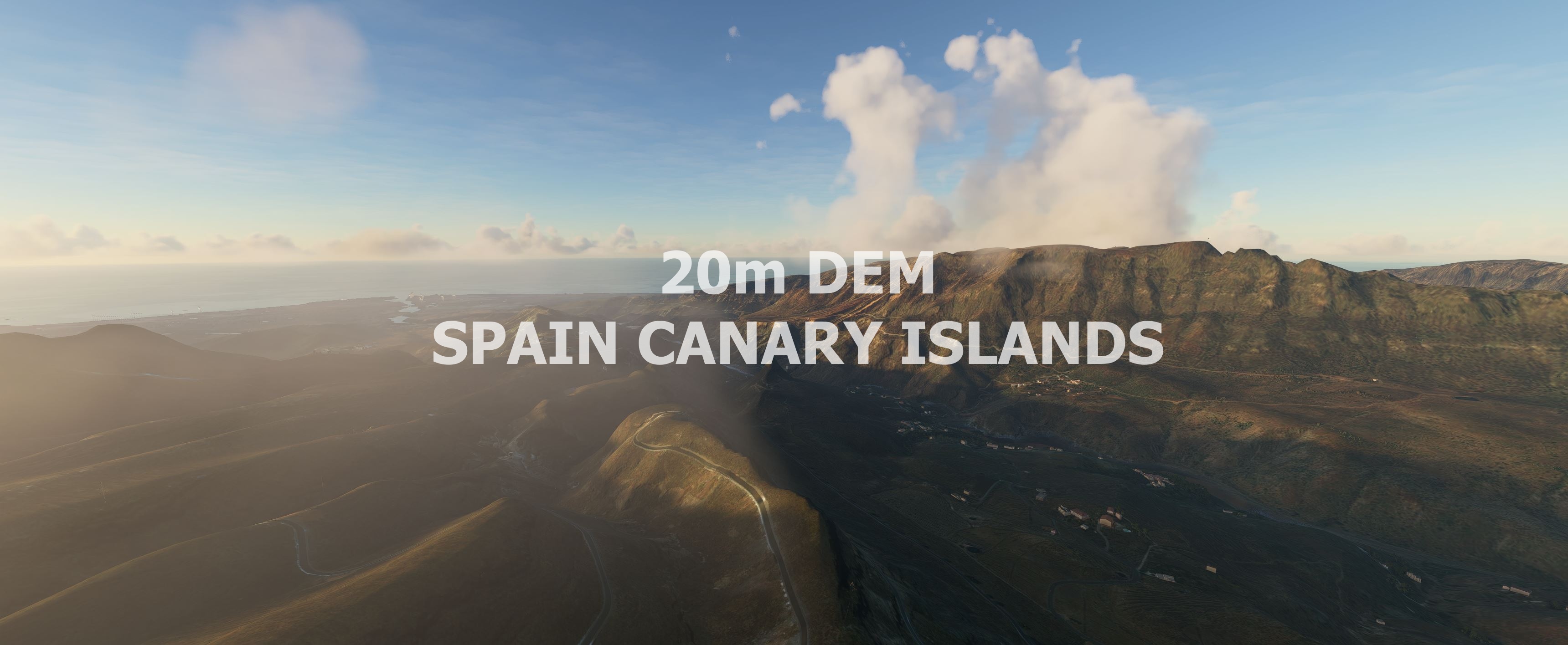
This mod contains customized height profiles for the Canary Islands. The mod contains high definition LIDAR DEM data with a mesh resolution of 20m. The height resolution is as good as 0.1m.
The mod does not only provide mountain shapes being very close to reality, but also flattens lakes & rivers and gets rid of any terrain artifacts.
IMPORTANT
Disclaimer: The creator of this mod is not responsible for any problems, damage, incompatibilites to other mods or performance issues that might occur.
Please note, that this mod is a very high resolution mesh. The elevation data is applied through terraforming rectangles, thus loaded at a certain distance from the player. When travelling fast or at high alitude (wide range of view) there might be too many new rectangles loaded simultaneously and thus stutters might occur.
If you have any stutters you can try and reduce your ingame render settings or uninstall!
If you are mainly flying airliners in high altitude, there is probably no benefit for you in using this mod.
Credits
The elevation data used was a LIDAR 20m height profile compiled by Sonny (https://data.opendataportal.at/dataset/dtm-europe)
It was then transfered into MSFS using MSFS Toolkit by Nool Aerosystems (https://msfs.nool.ee/)
Thank you both and for anyone reading this: Please go ahead and support them!
Thanks Troglodytus for you help!
Enjoy your VFR flights above the Canary Islands!
Comments(46)
Log in to join the discussion
Log Inover 4 years ago
Is this compatible with WU8?
over 4 years ago
Try and error, but i think you dont need it anymore.
over 4 years ago
Hey, great job on the DEM! I really love flying in the canaries as I also fly there irl on vacation :) However on my end there is one really annoying issue I never noticed on any other DEM:
If I fly from let's say La Gomera to Fuerteventura the game quiet often freezes (not just stutters) when loading the DEMs of the other islands. I already also reinstalled windows but still this issue occurs. As said, on other DEMs it does not seem to happen.
Probably you could revisit this one and check it on your end :)
Best regards!
almost 5 years ago
Thanks for the DEM - amazing difference from Asobo default.
May I mention that your mesh is causing a huge sea dome just before the GCLA 36 threshold. Impossible to fly an approach.
Thanks!
Edit: Tried the GCLA freeware on its own without your DEM and the dome isn't present..
almost 5 years ago
The big sea dome is there with freeware https://de.flightsim.to/file/9967/gcla-la-palma-airport-canary-islands
almost 5 years ago
Can confirm, I only have the DEM active and no other addon at all, and the water dome is there.
almost 5 years ago
Awesome addon! I made this video featuring this addon and others, and it looks insane! Thanks!
almost 5 years ago
Thanks! Are you also planning on aerial imagery? Since all islands need to be color corrected massively and there is no freeware to do so (yet)
almost 5 years ago
Looks pretty good. Is there a chance of a 2 or 5m DEM?
almost 5 years ago
That allways depends if there is data available. Do you know a source?
almost 5 years ago
Speed94 hatte eine Quelle benannt. Kann man die nicht verwenden?
https://centrodedescargas.cnig.es/CentroDescargas/locale?request_locale=en
BG
almost 5 years ago
maybe it is possible, just took a quick look. dont know if the .asc format can be converted to a geotiff but i think that should work. at the moment i dont have any plans to do more DEM's. :)
about 5 years ago
Hi everyone ! Thanks for this amazing work. However, I think I'm doing something wrong because I see a lot of incorrections, terrain bugs, little mountains in the sea. Do you have an idea to fix it up ?
about 5 years ago
Should I use this add-on with or without "Canary Islands fix (rivers, trees)" to get the best effect? :)
How does this add-on cooperate with payware "ISLAND CREATIONS - FUERTEVENTURA AERIAL IMAGERY PREMIUM MSFS"? Is it compatible?
Spain Canary 20m DEM - High Resolution Terrain Elevation Data from LIDAR Imaging
High Resolution Terrain Elevation Data for the Canary Islands, featuring a 20m mesh resolution derived from LIDAR imaging. Enhances mountain shapes, smooths lakes and rivers, eliminating terrain anomalies for a more realistic experience. Caution: High-res mesh may result in performance-related issues; recommended for VFR flights at lower altitudes. Credits to the data source and tool creators for their contributions to this mod.

User Reviews
20 reviews
More Information
Version History
Excluded - All airports to avoid new bumps
Related

Swiss mountains tree fix (trees on mountains removed)
A comprehensive mod fixing tree placement on Swiss mountains, particularly removing inaccurately placed trees on mountain peaks. The update includes a shift to more realistic conifer trees in the Alps and an expansion to border areas of France, Italy, and Austria. From Alpstein Säntis to Stockhorn, numerous locations across Switzerland have been meticulously corrected for a more authentic flight experience.
by THEOLI4D

Shorter Trees / Tree Height Modification VERSION 4.0 for MFS2020 (shorter, realistic trees)
Experience realistic and shorter trees in Microsoft Flight Simulator with the Shorter Trees / Tree Height Modification VERSION 4.0 add-on. Compatible with the latest version of MSFS, this mod provides adjusted tree heights for a more authentic flying experience. Update includes enhanced tree coloration blending seamlessly with photogrammetry trees. Installation is simple - just copy the folder into your community folder and enjoy a new perspective from the skies.
by ARIF STUDIOS - Adnan Arif

AUSTRIA 10m DEM - High Resolution Terrain Elevation Data from LIDAR Imaging
Explore the stunning terrain of Austria with this mod featuring high-resolution LIDAR data, offering a mesh resolution of 10m for a more realistic flight experience. Flatten lakes, rivers, and eliminate any terrain artifacts as you soar over the Austrian landscape. Divided into regions for convenience and performance optimization, this mod enhances the mountain shapes to mirror reality and provides a smoother flying experience. Experience Austria like never before with enhanced elevation data and realistic terrains.
by Troglodytus

SWITZERLAND 20m DEM - High Resolution Terrain Elevation Data from LIDAR Imaging
Explore the beauty of Switzerland with this mod offering high resolution terrain elevation data using LIDAR imaging. The mesh resolution is 20m, providing exceptional detail with a height resolution of 0.1m. Update includes extreme LIDAR meshes for specific regions. Please note potential performance impacts and report any bugs for further improvements. Fly VFR over Switzerland with enhanced realism and accuracy.
by Troglodytus
over 1 year ago