Description
This scenery is designed to fit in with my other scenery upload "Hamburg Port (fits with Hamburg Finkenwerder (With Airbus Plant)"
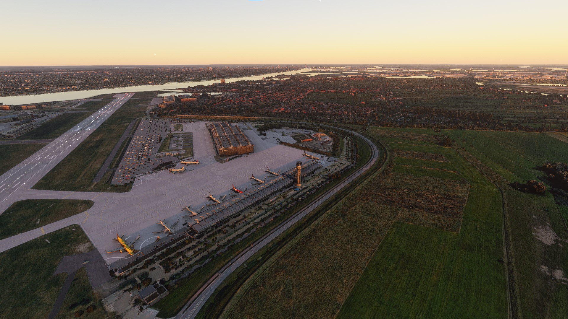
This package introduces Google Earth Satellite Data for the Airbus airport and plant EDHI in Hamburg, as well as the surrounding area of Finkenwerder. The textures have been colorgraded to better fit with MSFS textures. This avoids the blue tinting you may see in other photogrammetry imports.
Since the data used is roughly from 2018, five A380s can still be found on the plant for you to compare airplane sizes to. :-)
Installation:
Download -> extract -> place in your community folder.
Some notes:
This is the best currently possible resolution. Furthermore, there is no collision data available, so you can drive and fly straight through the newly added structures.
"Update" Note (May 2022): Google has updated its satellite data, but if I try to grab it with the "Google Earth 2 MFSF" tool, I still get the old data. It is possible to grab the Google Maps data with a much more labarious way (using RenderDoc). Perhaps I will do it sometime. If you don't want to wait, feel free to try it out for yourself. Tutorials are available on YouTube.
Video Preview of the scenery: https://www.youtube.com/watch?v=2kZY-qVZ1IM
Comments(22)
Log in to join the discussion
Log Inover 3 years ago
Unusable in current condition. Too bad.
almost 4 years ago
SU10?
almost 4 years ago
Static planes are totally crap!
about 4 years ago
Completely broken. No response from auithor. Should be removed.
over 4 years ago
over 4 years ago
Sieht leider wie ein Flugzeugschrottplatz aus ... schade ...
over 4 years ago
geht mir genau so.... alles extrem matschig.
over 4 years ago
update pls..................................
over 4 years ago
update pls.....
almost 5 years ago
Schade! Anstatt der Flugzeuge sehe ich nur weiße Polygone.
almost 5 years ago
since SU5 made framerates near ground more manageable, would it be possible to make a higher res version of this?
Greetings,
Paul
about 5 years ago
Habe leider das Problem, dass Gebäude und Flugzeuge aussehen wie nach einem Bombenangriff. Besonders der westliche Teil ist betroffen. Würde ja gerne einen screenshot anhängen. Ansonsten aber schon sehr gut.
about 5 years ago
bei mir auch!
almost 5 years ago
Jo, bei mir auch. Aber ist ja offiziell auch nicht kompatibel... ich warte mal auf ein Update. :-)
about 5 years ago
about 5 years ago
about 5 years ago
about 5 years ago
Hamburg Finkenwerder (With Airbus Plant)
Explore the detailed Hamburg Finkenwerder scenery with the Airbus Plant addon, featuring Google Earth Satellite Data and colorgraded textures for a realistic experience in MSFS. Witness five A380s at the plant for size comparison and immerse yourself in the surroundings of EDHI airport. Simply download, extract, and place in your community folder to enjoy this enhanced visual experience.

User Reviews
7 reviews
Location
More Information
Version History
No version history available.
Related

Swiss mountains tree fix (trees on mountains removed)
A comprehensive mod fixing tree placement on Swiss mountains, particularly removing inaccurately placed trees on mountain peaks. The update includes a shift to more realistic conifer trees in the Alps and an expansion to border areas of France, Italy, and Austria. From Alpstein Säntis to Stockhorn, numerous locations across Switzerland have been meticulously corrected for a more authentic flight experience.
by THEOLI4D

Shorter Trees / Tree Height Modification VERSION 4.0 for MFS2020 (shorter, realistic trees)
Experience realistic and shorter trees in Microsoft Flight Simulator with the Shorter Trees / Tree Height Modification VERSION 4.0 add-on. Compatible with the latest version of MSFS, this mod provides adjusted tree heights for a more authentic flying experience. Update includes enhanced tree coloration blending seamlessly with photogrammetry trees. Installation is simple - just copy the folder into your community folder and enjoy a new perspective from the skies.
by ARIF STUDIOS - Adnan Arif

AUSTRIA 10m DEM - High Resolution Terrain Elevation Data from LIDAR Imaging
Explore the stunning terrain of Austria with this mod featuring high-resolution LIDAR data, offering a mesh resolution of 10m for a more realistic flight experience. Flatten lakes, rivers, and eliminate any terrain artifacts as you soar over the Austrian landscape. Divided into regions for convenience and performance optimization, this mod enhances the mountain shapes to mirror reality and provides a smoother flying experience. Experience Austria like never before with enhanced elevation data and realistic terrains.
by Troglodytus

SWITZERLAND 20m DEM - High Resolution Terrain Elevation Data from LIDAR Imaging
Explore the beauty of Switzerland with this mod offering high resolution terrain elevation data using LIDAR imaging. The mesh resolution is 20m, providing exceptional detail with a height resolution of 0.1m. Update includes extreme LIDAR meshes for specific regions. Please note potential performance impacts and report any bugs for further improvements. Fly VFR over Switzerland with enhanced realism and accuracy.
by Troglodytus
almost 2 years ago