
Description
La Haute Route (trans: The High Road) is a rough trail between Chamonix, France and Zermatt, Switzerland. Made on foot and skis over alpine ridges and glaciers since the 1800s, it usually takes between one and two weeks to travel. This Bushtrip is inspired by this trail, and extends it.
Take a tour of the Alps starting from the French town of Sallanches near Chamonix, at the foot of the Mont Blanc, Europe's highest mountain. We will use glaciers as roads to cross over into southern Switzerland and again crossing briefly into Italy through Zermatt, before heading into Eastern switzerland and around to Lake Lucerne via numerous scenic passes and valleys.
I have been told that this Bushtrip is to be considered "Advanced" - for those who enjoy a challenge.
Once you have completed this bushtrip, Part 2 can be found here :
La Haute Route - Alpine Bushtrip Part 2
Current Version 2.0 by Dready1906
https://flightsim.to/file/5533/la-haute-route-alpine-bushtrip-part-2
Created using :
BushTripInjector
Current Version 0.2.5.435 by BuffyGC
https://flightsim.to/file/4131/bushtripinjector
Many thanks to BuffyGC for an excellent tool which he is continuously working to improve, and for the 30 or so emails we traded over the past couple of weeks working out various bugs and issues.
INSTALLATION:
================
Simply unzip the file, and copy the resulting folder and contents into the Community folder.
REQUIRED ADD-ONS:
==================
This bushtrip uses the very nice livery of REGA, the Swiss air rescue and air ambulance service. You can find it here.
X-Cub Rega Swiss Air Rescue
Current Version 1.1 by ANN0V
https://flightsim.to/file/4481/x-cub-rega
IMPORTANT NOTES:
================
1) There are numerous climbs to high altitude on this trip. FS2020 disables the Automixture feature in Bushtrips so you will have to manage the Fuel Mixture yourself. Above 10,000 feet mixture should be around 50-40%, otherwise you will find yourself out of power and unable to climb. If you find yourself unable to reach altitude for a certain pass, you should have room to circle and keep climbing before resuming your route.
2) The Navlog instructions are detailed with pictures, sometimes with routes marked with arrows, and hints as to when you should start climbing, as sometimes steep elevation changes will creep up on you. I strongly suggest you use the Active Pause feature (key it to the Pause button on your keyboard), and periodically stop and check the entries on the next few waypoints. This is also a good time to check out the scenery.
3) The GPS course is loaded into the X-Cub's navigation system, so you can look at the course indicator on the PFD if you are confused by the Navlog instructions. If you don't want to see these 'hints' you can change the CDI source to NAV1 or 2 and you won't see them. The autopilot NAV mode works as well, but I would not recommend that because some of the waypoints show a straight line when actually you have to dodge a few mountains in the way.
4) When starting a new leg, you will spawn where you ended the previous leg. On this bushtrip, this may be uphill on a steeply sloped airstrip, headed the wrong way for takeoff. So when spawning, immediately make sure your brakes are on, and check if you need to taxi to a proper takeoff position.
5) While the total distance is not great, and estimated completion time (calculated by FS2020 as the distance at the X-Cub's maximum cruise speed) is only a bit over 3 hours, in reality it will take you quite a bit longer, because of all the altitude changes (BTW best climb speed in the X-Cub is 55-60 knots).
LEGS
=====
1) Mont-Blanc (LFHZ) to Verbier (LSVE) over the Argentiere Glacier
2) Verbier (LSVE) to Raron (LSTA) an easy leg up the Rhone Valley
3) VFR Raron (LSTA) to Domodossola (LICH) via Zermatt and the Gornerglacier
4) Domodossola (LICH) to Ambri (LSPM) over the Passo San Giacomo
5) Ambri (LSPM) to Locarno (LSZL)
6) Locarno (LSZL) to Samedan (LSZS) over the San Bernardino and Julier Passes
7) Samedan (LSZS) to Bad Ragaz (LSZE) via Davos
8) Bad Ragaz (LSZE) to Mollis (LSMF) a short lakeside jaunt
9) VFR Mollis (LSMF) to Bouchs (LSZC) over the Pragel Pass and a close flyby of the Rutli
... and more to come as some mountain airstrips become (hopefully) available.
SUGGESTED ADD-ONS:
==================
All of these are optional, strictly speaking, but do enhance the experience.
1) Mythen (WIP)
Current Version 0.2 by ChruutvoLuzi
Adds the distinctive Mythen mountain(s) near Brunnen (Leg 9).
https://flightsim.to/file/1776/mythen-wip
2) Gornergrat
Current Version 1.01 by musician262
Changes the Gornergrat observatory (Leg 3) to its actual appearance rather than a generic apartment block - albeit one at 10,000 feet.
https://flightsim.to/file/2221/gornergrat
3) LICH - Aviosuperficie Chavez/Marini - Masera (ITALY)
Current Version 1.0 by LoscoNosciuto
Adds details to airport at end of 3rd leg.
https://flightsim.to/file/2321/lich-aviosuperficie-chavez-marini-masera-italy
4) Matterhorn
Current Version 2.0 by zkhcohen
Dramatic improvement of the Matterhorn seen on 3rd leg.
https://flightsim.to/file/7564/matterhorn
5) Swiss Airfields
Current Version 0.12 by mrbump
Improves Bad Ragaz airfield at the end of Leg 7, and hopefully others eventually.
https://flightsim.to/file/2798/swiss-airfields
6) Saint Moritz - Samedan Airport LSZS (Swiss) v1.3
Current Version 1.3 by Sergio Del Rosso
Full upgrade of Samedan Airport at the end of Leg 6.
https://flightsim.to/file/3361/saint-moritz-samedan-airport-lszs-v1-0
7) Basilique de Valère et château de Tourbillon Sion
Current Version 1.0 by legofun1974
Converts the hilltop castle and basillica at Sion (Leg 1).
https://flightsim.to/file/2938/basilique-de-valere-et-chateau-de-tourbillon-sion
8) ItalyDEM
In spite of the name, this mod updates the digital elevation data for all of Switzerland, making the terrain more realistic - not perfect but a definite upgrade over a lot of the lo-res data currently in the sim.
Current Version 1.0 by sprightlyoldman
https://flightsim.to/file/5552/italydem
9) Churfirsten (Mountain Range) Switzerland
Current Version 1.0 by Bruchpilot80
https://flightsim.to/file/7186/churfirsten-mountain-range
A PERSONAL NOTE
================
I grew up in Switzerland and I am quite familiar with all the locations on this Bushtrip (although not by air). There are several more spectacular places I want to share with everyone, but I want to wait until a couple more mountain airstrips become available. The current version has 9 legs - I have 6 more planned out and just waiting for those airstrips, going through the Bernese Oberland and ending at Gruyeres. Right now they just aren't feasible without uncomfortably long legs, so I'll keep them for a future update.
My grandparents made the trek over La Haute Route in around 1950 during the winter, and I remember as a child my grandmother showing me her pictures from that journey. These memories inspired me to do this bushtrip, and as the Chamonix-Zermatt route was covered in only two legs, I just kept going :-). So this one is for you, Mamita.
Comments(35)
Log in to join the discussion
Log Inover 2 years ago
almost 4 years ago
A good trip but unfortunately now (August 2022) the leg 8 destination is no longer available in the sim as LSMF, so completing the leg fails to register. The ICAO code for Mollis Mil is now LSZM.
almost 4 years ago
Thanks for letting me know. I'll repair that.
about 5 years ago
Superbe voyage, magnifique! Merci beaucoup!
about 5 years ago
over 4 years ago
J'aimerai bien faire une traduction, mais mon francais est un peu limite, et je n'ai pas de clavier francais - les accents serait penibles.
about 5 years ago
about 5 years ago
Hope you enjoy it.
about 5 years ago
I tried to delete the bushtrip folder/files, launch/exit the game and install again and it's still the same
over 5 years ago
PA from GPVR
Do you live in French-speaking Switzerland? You want to share your passion for our discord, multi-player flight, get advice on aviation or hardware or get training? Then join the GPVR Group of Virtual Pilots Romands
www.gpvr.ch
Vous habitez en suisse romande ? Vous voulez partager votre passion sur notre discord, de vol multi-joueurs, avoir des conseils sur l’aviation ou le hardware ou obtenir des formations ? Alors rejoignez le GPVR Goupe des Pilotes Virtuels Romands
www.gpvr.ch
over 5 years ago
Thanks for you effort.
over 5 years ago
over 5 years ago
over 5 years ago
over 5 years ago
over 5 years ago
Let me see if I can dig up the original files for the trip, If I don't have to recreate everything from scratch, I might just go ahead and include the REGA livery which is really nice and appropriate. REGA is an air rescue/ambulance service in Switzerland, and their scheme is pretty nice.
I'm glad you enjoyed the trip.
over 5 years ago
La Haute Route - Alpine Bushtrip
Experience an advanced bushtrip inspired by the iconic La Haute Route, spanning from Chamonix, France to Zermatt, Switzerland. Prepare for challenging ascents, spectacular glacier crossings, and breathtaking alpine scenery. Explore the Alps in this unique journey that promises a test of skill and a salute to historical adventurers. Complete Part 1 and gear up for even more adventure in La Haute Route - Alpine Bushtrip Part 2.

User Reviews
11 reviews
More Information
Version History
- Changed the starting runway - Set the Livery to the REGA addon livery for XCub.
Related
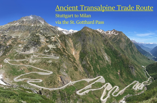
Medieval Transalpine Trade Route
Experience the historic Medieval Transalpine Trade Route bushtrip, flying from Southern Germany to Northern Italy via the scenic St. Gotthard Pass. Travel through picturesque landscapes, visit iconic landmarks, and enjoy detailed instructions in the Navlog. Enhance your journey with optional add-ons to enrich your flight simulation experience.
by Dready1906
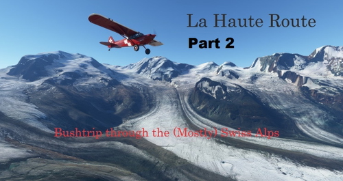
La Haute Route - Alpine Bushtrip Part 2
Embark on a high-altitude adventure with La Haute Route - Alpine Bushtrip Part 2, an extension of the challenging trail inspired by the historic path between Chamonix and Zermatt. Traverse the stunning alpine landscapes from Lake Lucerne to the summit of Mont-Blanc, experiencing expert-level flying through the Bernese Oberland and beyond. Explore recommended optional add-ons for an enhanced scenic immersion along the way.
by Dready1906
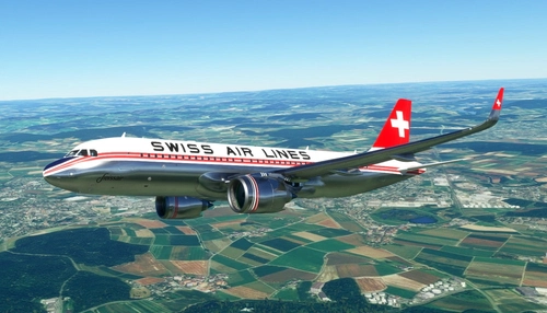
FBW A32NX SWISSAIR Retro Livery
Fly in style with the FBW A32NX SWISSAIR Retro Livery, a stunning adaptation of the classic Swissair livery from the 1940s and 50s, originally used on DC-3s and DC-4s. Created by miempa and converted for the A32NX, this livery captures the nostalgia of aviations golden age.
by Dready1906
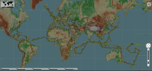
World Capital Mission (with Flightplans)
Embark on a unique journey to the worlds capital cities in a TBM-930 with no intermediate fuel stops. Land at each capitals closest airfield in this challenging mission from Ottawa to South Tarawa. Follow the detailed flight plan and experience the thrill of landing at diverse airstrips across the globe. Additional add-ons are recommended for an enhanced simulation experience.
by Dready1906
over 1 year ago