Description
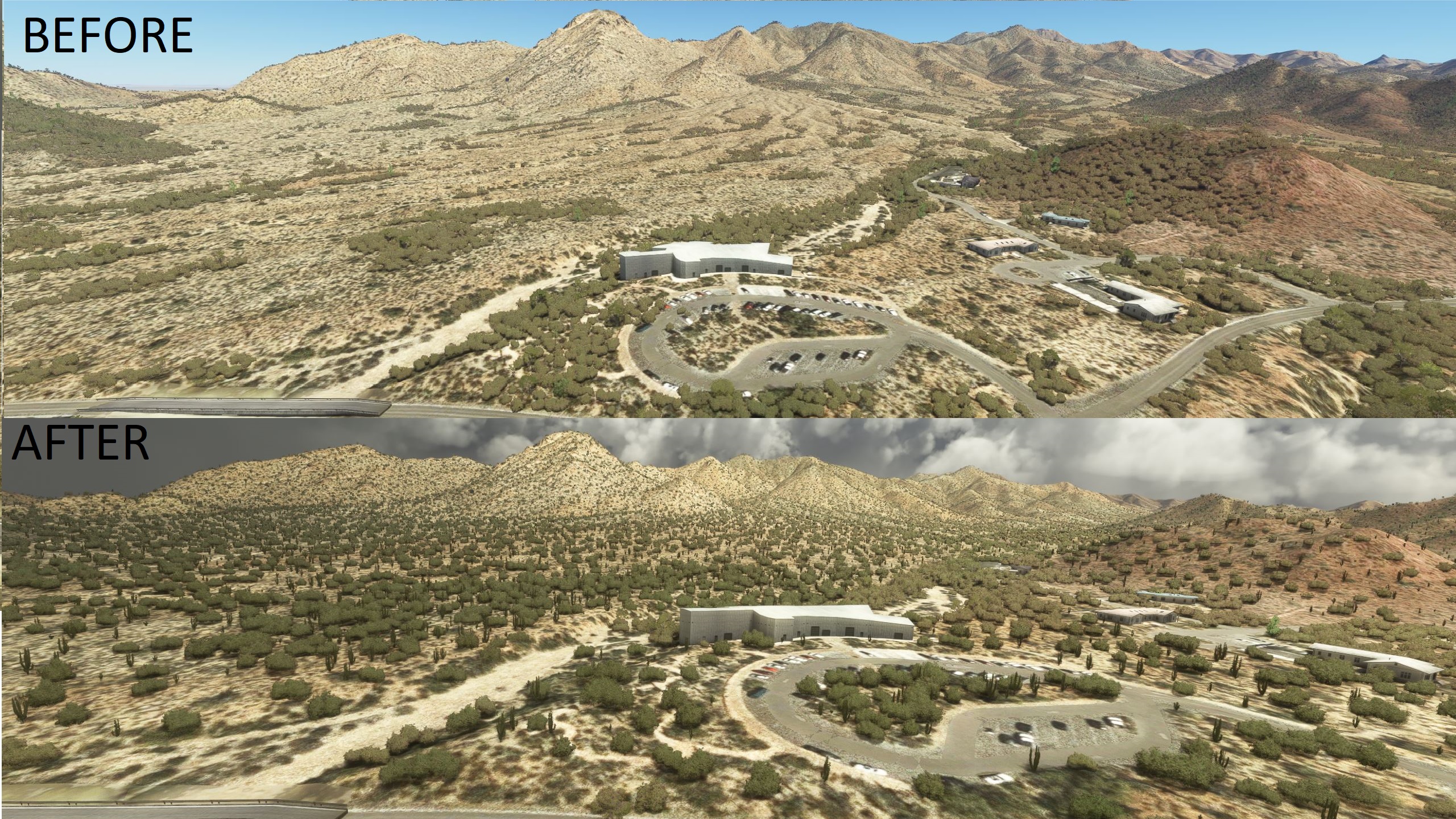
The Arizona vegetation biome has always been neglected in every flight sim since...well ever. Every addon I have ever bought that was supposed to fix how arizona looks left me dissapointed...Yes even that one very popular tree mod... I decided I would fire up the SDK and Youtube and learn to fix it. So after 90 hours and 3 weeks worth of dawing hundreds of polygons and defining vegetation biomes for the Tucson area I have what I feel represents Tucson pretty well.
The odd thing is that Asobo created the cactus biome but then used the cactuses everywhere they don't go in real life. This is an extensive re-vegetation as well as some de-vegetation.
This mod covers from Picacho Peak in the north to Green Valley in the south. Sandario road in the west to Vail in the east.
Just some points of the points of interest that now look much better. Tucson Airport surrounds, Black Mountain, All of the minor south Tucson Mountains, Ryan Airfield surrounds, Gates Pass, Desert Museum, Saguaro NP West Red Hills Center, A Mountain, Torolita Mountains, Dove Mountain area, Marana low lands and Santa Cruz river, The mountains above Oro Valley. Mount Lemmon, Vail, Saguaro NP East, lower Reddington,
Everything I did is too extensive to list. Just hop in something low and slow and go enjoy Tucson the way it was meant to look.
Works with or with out photogammetry but was designed for use with photgrammetry.
Also, works best with my Tucson water removal mod, but it is not required.
I do not know how it will behave with seasons and other tree mods. Try it out and let me know. This file is very simple its just a lot of biome defintion polygons and exclusions so nothing can harm your system. My gut feeling is that is should override any other mod and look like it does in the screen shots.
Frame rate impact is negligable, if any
The result is not perfect, the bushes are too big and numerous compared to the saguaros so I had to find a happy medium. When you increase the density it makes more bushes so it's a balancing act.
Installation: unzip folder and place train-tucson-veg folder in your community folder.
Also, check out my newly released Phoenix area scenery that incorporates vegetation and water fixes.
https://flightsim.to/file/35812/phoenix-arizona-vegetation-and-water
Tucson Arizona Vegetation Replacement
Replaces 80% of the vegetation biome definitions in the Tucson Metro area and a little beyond. Grab a prop and go low and slow it actually looks like Arizona now. At least as good as the SDK allows with out special programming. You want Saguaros, we have them!


User Reviews
2 reviews
Location
More Information
Version History
-Lower vegetation density on final approach to 29R at Tucson- possible FPS impact and stutter - not sure if it was my scenery or not. Can't get a stable reading. FPS seems to be better now. -Fix 5 mile stark transition line near Dove Mountain, blended better. -Exclude switch for railroad line along Nogales Highway and a few other small areas. -Conifers added to Table Mountain and Prominent Point.
Related

Swiss mountains tree fix (trees on mountains removed)
A comprehensive mod fixing tree placement on Swiss mountains, particularly removing inaccurately placed trees on mountain peaks. The update includes a shift to more realistic conifer trees in the Alps and an expansion to border areas of France, Italy, and Austria. From Alpstein Säntis to Stockhorn, numerous locations across Switzerland have been meticulously corrected for a more authentic flight experience.
by THEOLI4D

Shorter Trees / Tree Height Modification VERSION 4.0 for MFS2020 (shorter, realistic trees)
Experience realistic and shorter trees in Microsoft Flight Simulator with the Shorter Trees / Tree Height Modification VERSION 4.0 add-on. Compatible with the latest version of MSFS, this mod provides adjusted tree heights for a more authentic flying experience. Update includes enhanced tree coloration blending seamlessly with photogrammetry trees. Installation is simple - just copy the folder into your community folder and enjoy a new perspective from the skies.
by ARIF STUDIOS - Adnan Arif

AUSTRIA 10m DEM - High Resolution Terrain Elevation Data from LIDAR Imaging
Explore the stunning terrain of Austria with this mod featuring high-resolution LIDAR data, offering a mesh resolution of 10m for a more realistic flight experience. Flatten lakes, rivers, and eliminate any terrain artifacts as you soar over the Austrian landscape. Divided into regions for convenience and performance optimization, this mod enhances the mountain shapes to mirror reality and provides a smoother flying experience. Experience Austria like never before with enhanced elevation data and realistic terrains.
by Troglodytus

SWITZERLAND 20m DEM - High Resolution Terrain Elevation Data from LIDAR Imaging
Explore the beauty of Switzerland with this mod offering high resolution terrain elevation data using LIDAR imaging. The mesh resolution is 20m, providing exceptional detail with a height resolution of 0.1m. Update includes extreme LIDAR meshes for specific regions. Please note potential performance impacts and report any bugs for further improvements. Fly VFR over Switzerland with enhanced realism and accuracy.
by Troglodytus
Comments(7)
Log in to join the discussion
Log Inover 2 years ago
https://www.youtube.com/watch?v=1ot-nBrVkjg
almost 4 years ago
Outstanding!
almost 4 years ago
Thank you!
almost 4 years ago
You did a very nice job!! I want to do the same in the northern coast of Patagonia. There is a big area where the IA put trees instead of bush (the biome is very similar to Arizona). Is there a nice tutorial to do this kind of job?? Thanks in advance.
almost 4 years ago
Look up Patriot Six on YouTube. He has a bunch of tutorials and is the most thorough. So many youtubers glossed over the fact you have to build the package first. So while production is questionable the info was the only series of videos where it finally clicked for me.
almost 4 years ago
Great work, thank you.
almost 4 years ago
Thanks, I tried to be as accurate as possible.