


Continuing with my mission to bring some of the forgotten airfields of Australia (forgotten by MSFS/Asobo that is) back into the sim world. I started in Far North Queensland (download my FNQ pack here) but today I present 15 obscure and not so obscure airfields of South Australia (SA).
Now, FNQ is pretty dry at times, but overall, SA is the most arid of Australian states. It’s also a lot windier. While in my FNQ pack most airfields tended to have a single runway in a generally east-west direction, due to the dominance of the south-easterly trade winds, many small fields in SA have two crossing runways, allowing pilots to cope with the searing north/north-easterlies during summer and the chilly south-westerlies during winter. SA is also the flattest part of Australia, with only few (but notably scenic) mountain ranges. Even so, many of the fields I have included have noticeable slopes, to the extent that some should be considered one-way strips.
As always, the ICAO designators, except for the first two, are made-up:
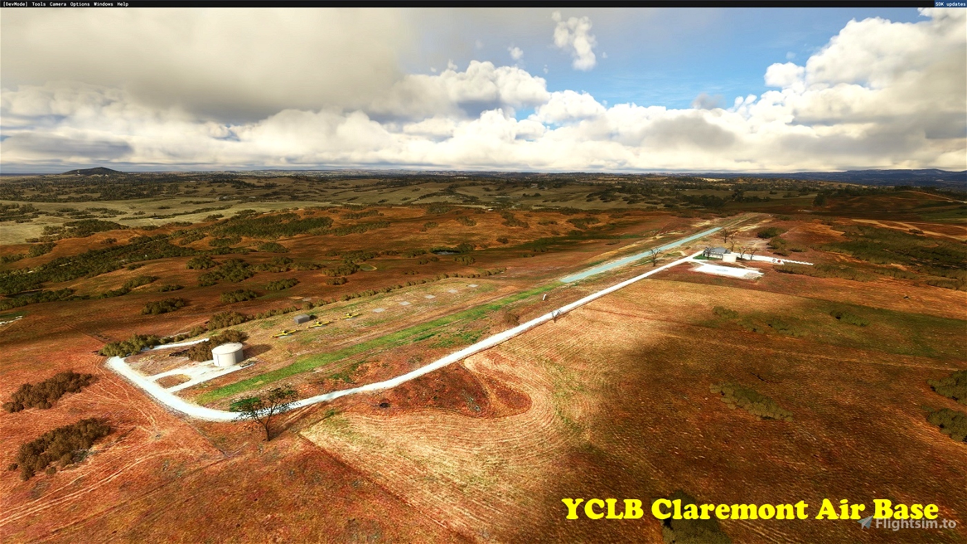
YCLB Claremont Air Base
No, not an Air Force Base, but rather the operating base of the SA Country Fire Service’s (CFA) aerial firefighters. YCLB is located high in the Adelaide Hills, right at the centre of the fire-prone south-east of the state. A pretty rough and tumble strip as far as “Air Bases” go, but the equipment (mostly AT-802s) and their pilots are well used to this kind of environment. The 1000-odd metre long runway exhibits a considerable slope, which must be taken into account when operating anything larger than the ATs. And yes, that blueish tinge in the sealed section of the strip is there in real life, but I have no idea why. On a side-note, this airfield has been operational since 2016, yet there is zero evidence of it in the Bing aerial imagery. Ah well…
-34.992681° 138.927848°
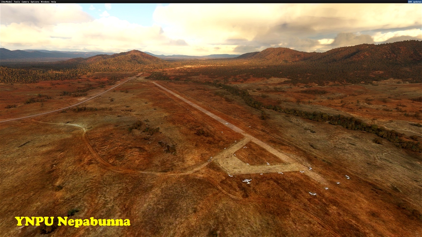
YNPU Nepabunna
Servicing a small Aboriginal community in the northern Flinders Ranges (aka Gammon Ranges), in a very scenic landscape. The field is located just west of the Iga Warta cultural centre, and has a moderately sloped 1,000-metre-long runway.
-30.598609° 138.898547°
YS01 Paney Station
Located at an old sheep station at the gateway to the truly ancient Gawler Ranges (more stunningly arid scenery), here we find two crossing runways, which are refreshingly level.
-32.663758° 135.663302°
YS02 Cameron Corner
Corner, because this is where the borders of New South Wales, Queensland and South Australia meet at a singular point. Cameron, because of the geodetic surveyor whose party located it back in 1879. The airstrip is situated on the South Australian side of the borders. Take note that to find a parking spot you’ll need take a short taxi along the road that marks the NE end of the strip. You’ll probably share the historic spot with a 4x4, a camper and a few hardy trail riders. Of note is the local section of the 5,614 km long “Dingo Fence” that marks the NSW borders. This is some truly arid country at the heart of the Strzelecki Desert, but luckily the pub, a short stroll across the border in Queensland, serves cold beverages.
-29° 141°
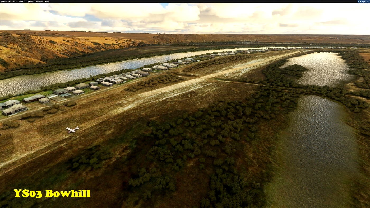
YS03 Bowhill
A shortish strip on a more or less permanent sand bank of the (once) “mighty” Murray River. Many of the riverside “shacks” are available as holiday rentals. Have a go at hooking one of those fabled Murray River Cods! The general store “up in town” allegedly serves quite a decent breakfast.
-34.888507° 139.610809°
YS04 Thuriga Homestead
Another sheep station in the arid Gawler Ranges, not far from the southern end of the dry salt “Lake” Gairdner. It’s also only a short hop away from “Lake” Acraman, the remains of an impact crater that dates back 580 million years. I told you this landscape is ancient!
-32.437483° 135.781622°
YS05 Cape Jaffa
A rough sand strip south of Kingston at Cape Jaffa. No facilities, but walking distance to the beach. There’s a new marina development to the south-west, so the place won’t be as quiet as it used to be for much longer.
-36.933715° 139.715811°
YS06 Hindmarsh Island Private
A private field on Hindmarsh Island, near the (generally barred) Murray River mouth. This is a short (500m) moderately sloped strip, so don’t attempt to land on 35 except in strong northerly winds.
-35.503997° 138.850737°
YS07 Mount Crawford
This strip is located in a large state forest pine plantation in the Mount Lofty Ranges. Beware of the turbulence often associated with these dark coloured, non-native forest plantations where they bake in the hot Australian sun. The strip slopes down towards the reservoir, but is long enough (1,180m) to operate in both directions.
-34.709064° 138.941980°
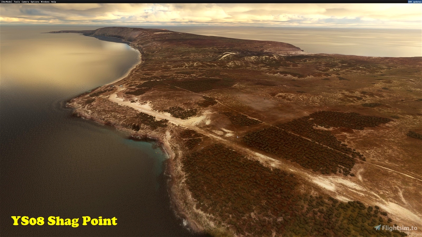
YS08 Shag Point
Located at the northern end of Thistle Island not far from Port Lincoln. There’s an “official” strip at the southern end (YTHI), but this one is more scenic. The island is popular with sea kayakers on weekend camping trips from Port Lincoln. The two sand strips are not well defined in real life, so I’m helping you a bit with a few gable markers. Don’t be tempted into using the “dogleg” that merges into Runway 30, as it has a considerable side-slope, lest you join the kayakers in the bay below.
-34.950567° 136.122922°
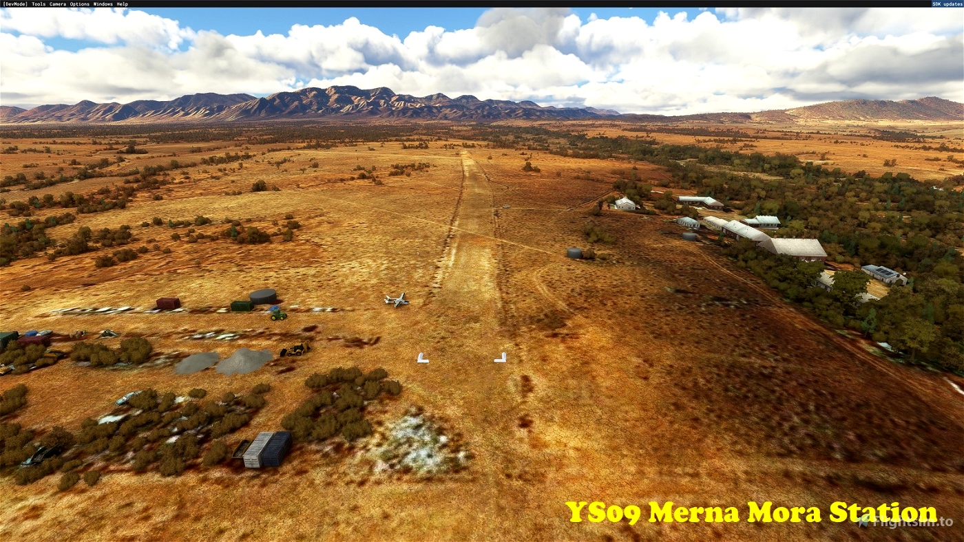
YS09 Merna Mora Station
Another sheep station, this one in the western foothills of the Flinders Ranges. The soil in these parts is way too poor to support any commercial livestock other than sheep. Expect some stunning sunsets that cast nearby Wilpena Pound into alpenglow.
-31.544678° 138.392987°
YS10 Angorichina Station
More sheep stations, this one in the heart of the Flinders’ just north of Blinman Airport (YBLM). This one probably makes as much money from the discerning tourism market as from sheep (or maybe that was before COVID). The strips are short and slope every which way, but the owner operates scenic flights from them in a 172, so you shouldn’t have too many issues as long as you’re careful.
-31.089778° 138.737372°
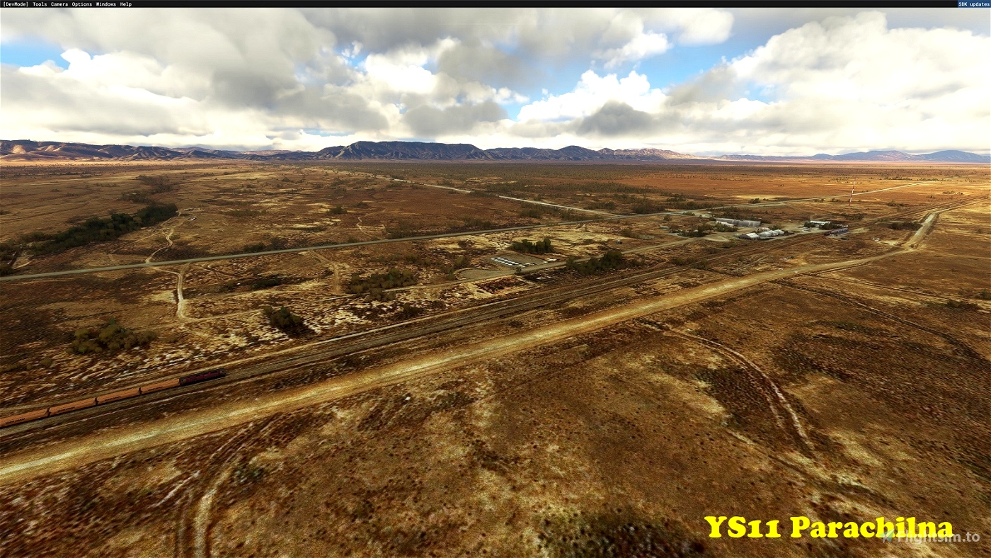
YS11 Parachilna
Head into the sunset from Angorichina (YS10), and once clear of the ranges you’ll soon come to Parachilna. But pay attention, the “town” is easy to miss, and has a permanent population of only 16 souls. The place was a bit more substantial way back when it sat along the old “Ghan” train line from Port Augusta to Alice Springs. Later on, the coal trains from Leigh Creek rumbled down to Augusta without stopping. These days there are not even coal trains left to disturb the still desert nights. The Prairie Hotel is still a popular watering hole though. The airstrip sits along the railway line. It’s really just a section of the service road widened to accommodate small aircraft.
-31.127032° 138.393214°
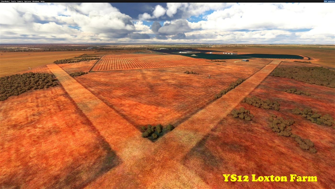
YS12 Loxton Farm
A small private farm strip (well 2 of them) near the Murray River town of Loxton.
-34.466567° 140.499084°
YS13 Murray Bridge Private
A small private strip (well 2 of them, again) on the southern outskirts of the Murray River town of Murray Bridge (there’s a theme there). The owner appears to be in the construction or earth moving business, judging from the type of junk scattered about.
-35.160066° 139.263892°
Installation
Simply copy the included folders into your Community folder. (If you are updating this scenery to a newer version, first delete the existing folders of the same name.)
Dependencies
You may wish to install my Australian Salt Lakes Fix mod (I highly recommend it!), as many of the airfields covered in this pack are near dry/salt lakes, which in the default sim contain unrealistic amounts of water.
In addition, you may also want to consider the excellent Powerline and Solar Farms mod for some added realism as quite a few of the Murray basin fields have powerlines in the vicinity.
To see the scenery objects I've placed, you will need to have the following object libraries installed:
MSFS 2020 object library with 190+ models ranging from towers hangars to cones by colinj
https://flightsim.to/file/16007/msfs-object-library-with-150-models-ranging-from-towers-hangers-terminals-to-cones
totof- aircraft library by Totof33120
https://flightsim.to/file/17182/totof-aircraft-library-v1-1
totof- helicopter library by Totof33120
https://flightsim.to/file/17983/totof-helicopter-library-v1
totof-library-object
https://flightsim.to/file/17179/totof-library-object-v1-1
BeeKay-Pack1
https://flightsim.to/file/8887/beekay-pack1
Dave’s Crooked Library by BadMed
https://flightsim.to/file/4696/dave-s-crooked-library
Dave’s 3D Animals Library by BadMed
https://flightsim.to/file/6841/dave-s-3d-animals-library
Mikea.at - AssetPack by mikea.at
https://flightsim.to/file/1923/mikea-at-assetpack
Windy Things by trfsto
https://flightsim.to/file/14024/windy-things
Moving Boats 3D Model Library by superspud
https://flightsim.to/file/27908/moving-boats-3d-model-library
Static Boast 3D Model Library by superspud
https://flightsim.to/file/27907/static-boat-3d-model-library
Pascal’s library by Pascal62
https://flightsim.to/file/16930/pascal-s-library
Emerald Object Library
https://flightsim.to/file/8824/emerald-object-library
AirHispania - Libraries
https://flightsim.to/file/5043/airhispania-libraries
Collection d'avions pour FS2020 by Jean-Pierre Fillion
https://www.jpfil.com/quebec-fs2020/scenes/Collection-avions.zip
Credit: Jean-Pierre Fillion, Quebec
quebec-fs2020.org
jpfil.com
Many thanks to the library object developers for making them available!
[Note: the scenery will function without these libraries, but will look less interesting.]

 gunther


A brilliant and much needed addition. Allows for some really scenic short flights when you don't have time!
2 years ago
Dexdoggy
Great additions, thanks.
2 years ago
fStopper
Fantastic work , thanks very much for your efforts
2 years ago
besso05
Nice work!
Not sure if you'd be interested a lot but there's a few regional airports in SA that need some work aha.
YWHA - Whyalla
YPLC - Port Lincoln
YPAG - Port Augusta
2 years ago
KiymJaery
Terrific work many thanks Gunther.
2 years ago
Adelaideguru
Great work! Thanks so much for the effort 😊
2 years ago
sarahymac