Description
NEW in v2.0: added Île de Sein
Pointe du Raz (local name in Breton Beg ar Raz ) is a promontory rock forming the foremost part to the west of Cap Sizun , opposite the Iroise Sea to the southwest of Finistere. Located to the west of the town of Plogoff, it forms a 72-meter high " prow " overlooking the Raz de Sein. It is one of the most emblematic sites of the granite coasts of Bretagne. The site obtained national recognition, granted by the Minister of the Environment under the Grenelle law, in 2010, by obtaining the Grand Site de France label.
Natural site of international notoriety, it is object of an important tourist frequentation. This human pressure required rigorous environmental protection measures as part of a large national site operation , to restore vegatation which is mainly composed of heather. To this end, businesses were moved, 2 hotels were destroyed and parking area was moved back one kilometer. The operation was carried out in 1996 - 2000 as part of a program funded by the State and corporate sponsors. The “Mixed Syndicate for the Development and Protection of Pointe du Raz and Cap Sizun” (bringing together the Community of Communes of Cap-Sizun , the Coastal Conservatory and the Departmental Council of Finistère ) manages the site. It was rewarded by the Ministry of Ecology, Sustainable Development and Energy for the quality of its management in June 2004.
The beauty of the site is enhanced by those of the nearby coasts which curve to the north along a large sandy beach at the bottom of the Baie des Trépassés, closed by the Pointe du Van beyond which extends the immense Bay of Douarnenez closed by the Cap de la Chèvre. Towards the south extends the Bay of Audierne.
Since Antiquity , the passage between the Pointe du Raz and the Ile de Sein, called the Raz de Sein, has been known to be very dangerous for navigation and more particularly, at night and in bad season, due to the violence of the sea currents. Therefore the lighthouse of the pointe and the lighthouse of the island were built as soon as the progresses in the illumination and optical equipment made during the first third of the 19th century allowed it.
The lighthouse of Bec du Raz, about 18 m high, was built in 1839 and lit at the same time as the lighthouse of Île de Sein. It was extinguished in 1887, because it was replaced by the inhabited lighthouse of La Vieille. A sheet metal turret carrying a more modest light was established around 1870 on the side of a cliff to the northwest in order to create a lighthouse-light alignment pointing on the islet of La Vieille. It was called “fire of the cliff of Raz” and was also extinguished in 1887. The base of the Bec du Raz lighthouse was then reworked to make it a semaphore.
Next to the semaphore, Notre-Dame des Naufragés is a sculpture by Cyprien Godebski made in 1904. The monument, 6 meters high, rises on a pedestal of 4.50m. The inauguration and blessing took place on Sunday July 3, 1904. Every year, the last Sunday of July, the forgiveness of Notre-Dame des Naufragés is celebrated.
La Vieille ("The Old Lady" or "The Wrass") is a lighthouse standing on the rock known as Gorlebella (Breton for "farthest rock"), guiding mariners in the strait Raz de Sein, across from the companion lighthouse Tourelle de la Plate—also known as Petite Vieille ("Little Old Woman"). It is among the small class of lighthouses around the coasts of France carrying the moniker "hell", due to a remote position in rough seas. La Vieille achieved notoriety in the 1920s when two disabled war veterans were stranded there for weeks by storms, their health deteriorating. They were employed under a new law reserving the job of lighthouse keeper to those who had served in the war. The tremendous difficulties experienced in getting them back to shore led to the repeal of the new law. In 1995 it was the penultimate French lighthouse to become automated.
The Phare de Tévennec is a lighthouse located in the northern part of the Raz de Sein off the Pointe du Van. Operationnal from 1875 then automated in 1910 because of its difficult access, it accompanies the light of La Vieille in securing the passage of the Raz de Sein, which presents many difficulties.
It was listed as a monument historique by a decree of December 31st, 2015.
According to Jean-Christophe Fichou and Francis Dreyer, the lighthouse is said to be "one of the strangest places in the history of lighthouses," and is rumored to be haunted.
During the Napoleonic Wars, the French ship Séduisant was wrecked there, resulting in the deaths of hundreds of men. The lighthouse was classified as the fourth category, requiring a single keeper and a service period of a year. A series of 23 keepers lived at the light until automation. According to legend, the first lighthouse keeper, Henri Guezennec, was driven insane by ghostly voices demanding his departure. Allegedly Guezennec’s replacement, Minou, had a similar experience. The French government then reclassified Tévennec as a two-man lighthouse however applications were rare. In 1897 the government began recruiting married couples to keep the lighthouse. Some unexplained deaths occurred. The first couple to accept the job were the Milliners. The most durable keepers, Louis and Marie-Jacquette Quéméré, followed them with their three children and a cow and remained five years. In 1907 a new couple replaced them, Msr. Roparz and his wife. More deaths occurred and a storm destroyed a part of the lighthouse while the keeper’s wife was in childbirth. Around this time the départment decided to automate the Tévennec light and service it every six months.
NEW in v2.0: The island of Sein, in Breton Enez-Sun, is a French island which gave its name to the municipality of Île-de-Sein.
A saying on the island is known to all sailors: "He who sees Sein sees his end". This was created to warn sailors of the existence of dangerous reefs around the Breton island and that the creation of a sea rescue service seems to confirm.
A strong tradition of singing has been maintained on the island, where young and old alike come together to sing sailors' songs and local songs together.
The Grand Phare de l'Île de Sein was built between 1950 and 1951. It replaces a first lighthouse built on the island of Sein in 1839 but destroyed in 1944 during the Second World War.
It was added to the register of historic monuments by decree of December 31, 2015.
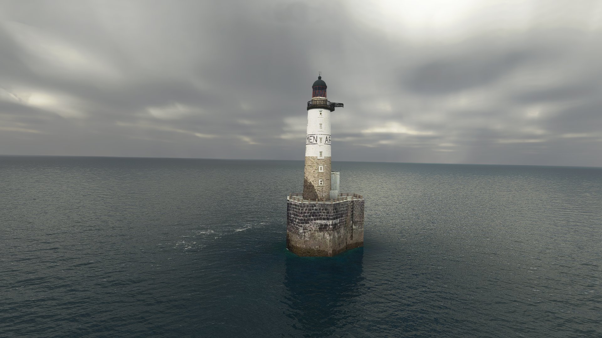
The Phare de Men Brial (in Breton: Ar Mên Brial ), is a lighthouse located in the entrance to the port of Île-de-Sein. The etymology of the Breton name Mên Brial is uncertain, it could derive from the name brezhell (mackerel) pronounced brehell on the island of Sein. Another hypothesis, krial meaning to cry, perhaps the women came to mourn the peris at sea at the exit of the port (Mên Grial).
The Phare d'Ar Men ("the rock" in Breton) is a lighthouse at one end of the Chaussée de l'Île de Sein, at the west end of Brittany. It shares its name with the rock on which it was erected between 1867 and 1881. It is a listed monument since 2017.
Ar Men is one of the best known lighthouses because of its isolated situation and the considerable difficulties its construction has presented, and the danger in evacuating its personnel. Considered one of the most challenging workplaces by the community of lighthouse keepers, it has been named "The Hell of Hells" because of the severe conditions and exposure to the Atlantic.
Eglise Saint-Guénolé was built at the end of 19th century. It bears the name of the first apostle on Île de Sein.
The chapelle Saint Corentin is located in Goulénez, far from the village, on a sacred place, probably the oldest on the island. It was built around the 15th century.
The corne à brume du Gueveur or Ar Guiveur is a lighthouse 20m above sea level, built in the 1930s, dynamited by the Germans in 1944 and rebuilt in 1947. It had the particularity of carrying a foghorn which fell silent on December 6, 2001.
The Amer de Plas ar Scoul is a fixed landmark used for navigation, located sourth of the Saint Corentin Chapel
The buildings of the Pointe du Raz and Île de Sein were recreated manually from various photos and videos from the Internet. The landmark and the lighthouse of Ile de Sein come with their own POI.
This mod is not intended for sale or resale.
Complementary mods:
-Pointe Saint-Mathieu: https://flightsim.to/file/17276/pointe-saint-mathieu
Pointe du Raz et Île de Sein
Discover the beauty and history of Pointe du Raz and Île de Sein in this detailed mod. Explore the iconic promontory and lighthouses, recreated from various sources for accuracy. New in version 2.0, experience the addition of Île de Sein and its landmarks, including the Grand Phare de lÎle de Sein. Rich in tradition and maritime lore, this mod offers a glimpse into the perilous yet captivating world of these Breton landmarks.

User Reviews
12 reviews
Location
More Information
Version History
-Added exclude for compatibility issue with France VFR Payware mod -Fixed some elevation issues on Ile de Sein
Related
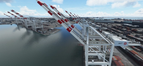
San Pedro Bay Port Facilities, Los Angeles & Long Beach CA USA (V3.0 MSFS2020) / (V1.3 MSFS2024)
This add-on provides detailed scenery enhancements for the San Pedro Bay port facilities in Los Angeles and Long Beach, California, specifically optimized for both MSFS2020 and MSFS2024. Version 3.0 for MSFS2020 features improved models, with significant updates including new cargo crane designs and streamlined asset management. The MSFS2024 version introduces additional upgrades and new details while ensuring compatibility with the latest simulator features.
by FreakyD

Kennedy Space Center
Explore the iconic Kennedy Space Center in Microsoft Flight Simulator with this detailed add-on, featuring key landmarks such as the VAB Building, Launch Control Building, and Launch Complexes 39A & 39B. Witness the impressive Falcon Heavy Rocket and SpaceX Rocket Assembly building as you embark on virtual space missions. Additional updates promise more buildings and assets to enhance your experience.
by Acktu
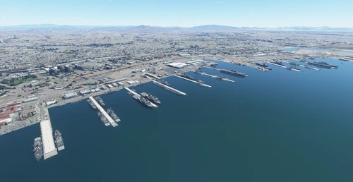
US Navy - San Diego V3.0.1
The US Navy - San Diego V3.0.1 add-on enhances the naval scenery around San Diego in Microsoft Flight Simulator. It includes a variety of updated ship models and improved textures, ensuring compatibility with both MSFS2020 and MSFS2024. Key features include detailed representations of the Rosecrans Submarine Base, multiple naval shipyards, and various classes of ships, including attack submarines and aircraft carriers. Recent updates have focused on model clean-up and the addition of interactive landing pads for helicopters.
by FreakyD
HungaryVFR FS2020
HungaryVFR is a package covering Hungary with airports and landmark sceneries, with its own library. The main goal is to bring as many airports and landmarks to Hungary as many we can, to have an authentic library for the are. The library can be used by other 3rd party scenery developers!
by ekre
Comments(28)
Log in to join the discussion
Log Inabout 1 year ago
about 2 years ago
over 3 years ago
salut, j'ai fait un vol dans le secteur. OK avec S10. Je mets des screens. Merci beaucoup c'est top
over 3 years ago
Toujours très sympas ces screens panoramiques
over 3 years ago
Du travail de grande qualité, je recommande cette scène, qui cumulée avec FranceVFR Nord Ouest ajoute énormément de réalisme dans ce secteur! bravo
over 3 years ago
Merci pour vos screens!
over 4 years ago
Grand Merci pour l'ensemble des réalisations. Immense travail de qualité. Bravo
over 4 years ago
Super, d'autres projets ? Oussant, Molène... pour améliorer la pointe Bretonne
over 4 years ago
Sans doute Ouessant, un jour, pour complèter la pointe St Mathieu
over 4 years ago
Superbe travail, un grand merci !
over 4 years ago
Félicitations, belle réalisation mais j'ai un doublon de phares AR MEN et SEIN avec france VFR qui gâche le paysage...
J'ai essayé de supprimer les fichiers des phares (fichiers PARMEN et PSEIN) dans le dossier Textuire d'obstacles et repères france VFR mais cela ne suffit pas, les doublons sont toujours présents (en blanc)mais sans texture, que faire ? Merci
over 4 years ago
Je vais faire un update en rajoutant des excludes pour ces zones mais je risque de ne pas être très disponible cette semaine.
almost 5 years ago
Merci pour ce travail. Même remarque que blb, le phare est en lévitation lorsque chez moi "obstacles et repères vfr" de France VFR est actif. Une fois désactivé, c'est OK, et il n'y a plus l'antenne dans le bâtiment.
almost 5 years ago
Ah ok, je vais rajouter un exclude alors en espérant que ça règle le problème.
almost 5 years ago
OK, je viens de tenter un fix avec la version 0.2, dites moi si ça règle le problème.
almost 5 years ago
Cela marche nickel même avec "O et R VFR" de France VFR. Merci.
almost 5 years ago
Super nouvelle; merci de votre retour sur le sujet!
almost 5 years ago
Un grand merci pour ce travail et pour notre Bretagne nationale.
almost 5 years ago
A nouveau, une réalisation très pertinente. Merci md46