Description
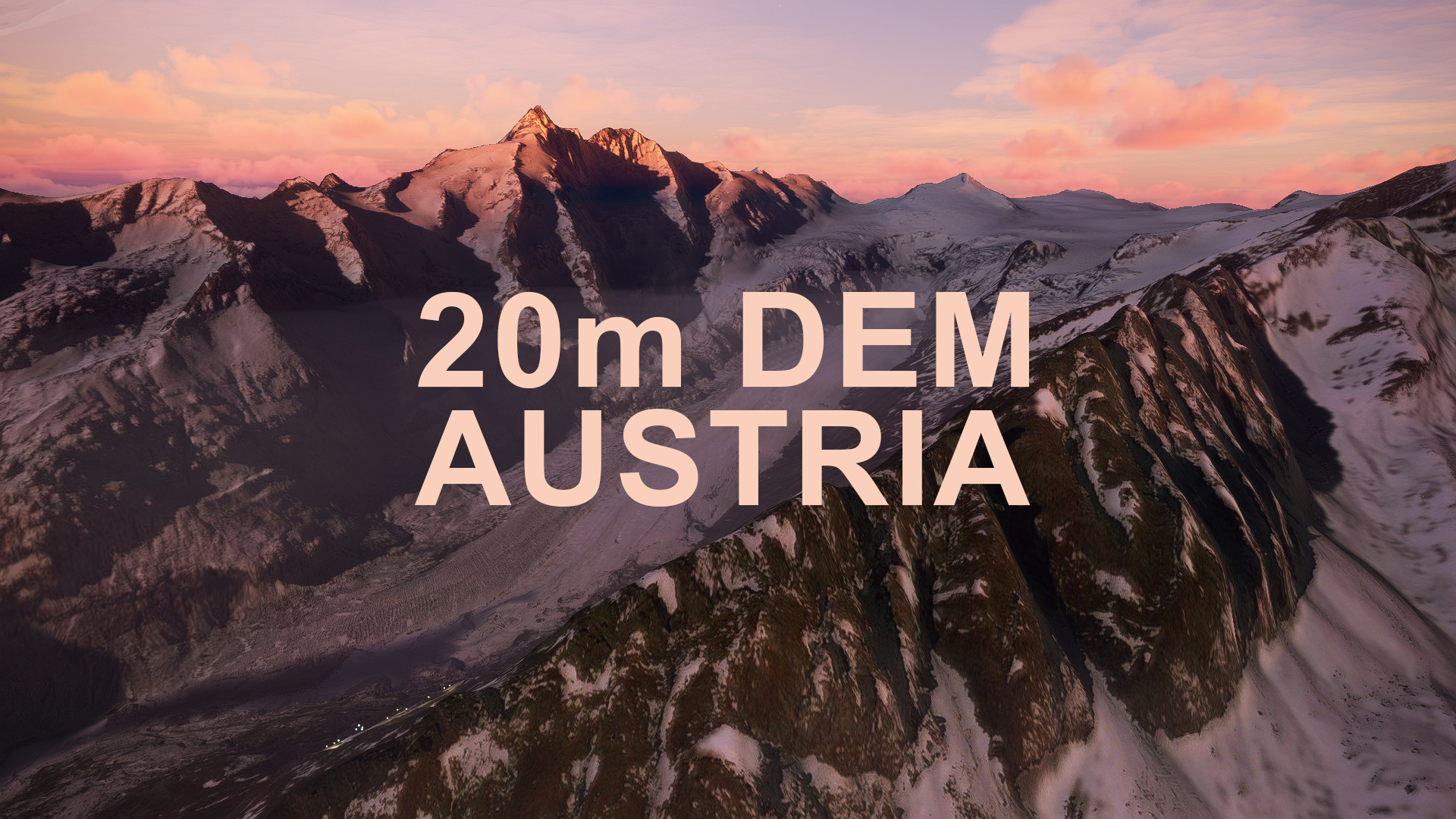
This mod contains customized height profiles for Austriad. The mod contains high definition LIDAR DEM data with a mesh resolution of 20m. The height resolution is as good as 0.1m.
The mod does not only provide mountain shapes being very close to reality, but also flattens lakes & rivers and gets rid of any terrain artifacts.
In comparison to the 10m DEM for Austria, this 20m mod is friendlier for lower spec PCs and therefore less stutters should occur. If you would like to have the most realistic landscape, you should switch to the 10m version.
IMPORTANT
Disclaimer: The creator of this mod is not responsible for any problems, damage, incompatibilites to other mods or performance issues that might occur.
Please note, that this mod is a very high resolution mesh covering the whole of Austria. The elevation data is applied through terraforming rectangles, thus loaded at a certain distance from the player. When travelling fast or at high alitude (wide range of view) there might be too many new rectangles loaded simultaneously and thus stutters might occur.
If you are mainly flying airliners in high altitude, there is probably no benefit for you in using this mod.
I tested it and generally speaking it is quite okay, but there might be some incompatibilities with scenery and airport mods. Certain objects might float or some bumps in the ground might occur, depending on the way that specific scenery was created.
Affected SceneriesTested several freeware and payware airports, they were mostly fine except of a few floating buildings here and there. Some fixes have been applied.
Please report any bugs or glitches and I will try to fix them.
The elevation data used was a LIDAR 10m height profile of Austria, compiled by Sonny (https://data.opendataportal.at/dataset/dtm-austria/resource/7fd4a6c3-16b8-4632-9978-10344c404a69)
It was then transfered into MSFS using MSFS Toolkit by Nool Aerosystems (https://msfs.nool.ee/)
Thank you both and for anyone reading this: Please go ahead and support them!
Simply unzip the download and copy&paste the contained folders into your "community folder".
Enjoy your VFR flights above Austria!
Comments(56)
Log in to join the discussion
Log Inover 2 years ago
about 4 years ago
Looks absolutely beautiful, thanks
almost 5 years ago
Hallo Troglodytus!
Was ist der Vorteil gegenüber dem Austria-update? Ist das DEM noch deutlich genauer? Sind die screenshots (default) schon nach dem Austria-update aufgenommen?
Ps: Ich kann es kaum erwarten deine LOAV und LOAN Szenerie genießen zu dürfen ;)
DEM zwar noch nicht getestet aber trotzdem 5 Sterne weil mmn alle deiner Arbeiten 5 Sterne verdient haben!!!
Herzlichen Dank
almost 5 years ago
Hallo!
Habe es eh ganz kurz bei den Versionshinweisen beschrieben: Das Standard Höhenmodell ist seit World Update 6 sogar besser als meine Mod, es gibt aber ein paar Vorteile der Mod:
Die Mod verursacht weniger "aufpoppen" von Datenpunkten. Vielleicht ist es dir schon aufgefallen, wenn man ganz nahe an Berge ranfliegt, dann tanzen die Felsen fast, weil so viele neue Höhenpunkte geladen werden. Der Effekt ist mit der Mod reduziert. Weiters sehen die Berge mit der Mod auch von weiter weg besser aus als ohne Mod, weil das Standard-Mesh viel früher zu schlechterer Auflösung hin interpoliert.
Dafür hast du mit der Mod halt 3 Gb mehr Daten auf deiner Festplatte..
Fazit: Mod hat Vor- und Nachteile, die man abwägen muss.
almost 5 years ago
PS: LOAV und LOAN machen uns derzeit leider einige Probleme, wegen Fehlern die Microsoft mit Sim Update 5 eingeführt hat. Sehe momentan leider keine Möglichkeit das zu veröffentlichen, weil einige Objekte strahlend pink leuchten.
almost 5 years ago
Vielen Dank für deine ausführliche Antwort! Werd mal morgen das DEM testen und ja das aufpoppen der Felsen ist wirkilch extrem nervig...
Hab den Eindruck die Updates machen 3 Schritte vor und zeitgleich 2 zurück xD Jedenfalls wollte ich dich wissen lassen wie dankbar ich dir für deine Bemühungen und auf großartige Weise bereichernden Arbeiten bin. Leider sieht es bei mir finanziell echt nicht gut aus, sonst würde ich dir eine fette Spende von Herzen gönnen!!
Alles Liebe Dir!
almost 5 years ago
Vielen Dank und viel Spaß beim Testen. Spenden sind natürlich willkommen, aber absolut nebensächlich, für Geld mache ich das nicht, sondern nur um nur um unser aller Simulatorerlebnis zu verschönern. Über so nette Kommentare wie deinen freue ich mich natürlich immer :)
almost 5 years ago
Danke für die Info und für Deine tolle Arbeit. Du leistest einen ganz großen Beitrag für die MSFS Community mit deinen MOD's die auch immer für erstklassige Qualität stehen! Drücke die Daumen für LOAV und LOAN!
almost 5 years ago
Hallo! Ich hab mir die DEMs schon einige Zeig angesehen und bin ein großer Fan davon. Bin damit schon recht viel in NÖ, St, K, T geflogen. Ich fliege gerne relativ "low and slow", am meisten in einer C152 oder auch C172. Ingame hab ich seit einiger Zeit alles auf Ultra, nur paar Effekte etwas niedriger eingestellt.
Das WU6 sieht meiner Meinung nach im Flachland und leicht hügeligen Gelände wirklich gut aus. Wenn´s "bergig" wird, beginnen teilweise Details der Berge "aufzupoppen", wenn man näher kommt. Ganz übel wird das WU6 aber für mich im "hochalpinen" Gelände, dort wo die Berge ganz ganz hoch und "zackig" aussehen... sollten. Das WU6 stellt hierbei einzelne Bergketten komplett "rundgelutscht" dar, zB In K, wenn man von LOWW kommend Richtung Venedig fliegt. Da sehe njdie - eigentlich höchsten Bereiche - extrem schlimm "abgerundet" aus.
Also, meiner Meinung nach, je "flacher" die Landschaft ist, desto besser funktioniert das WU6. Als "Freund der Berge", wenn man auch in alpine Regionen fliegt, hat man mit den DEMs bessere, teilweise sogar WESENTLICH bessere Ergebnisse, und das "Aufpoppen" von Details ist mit den DEMs auch nahezu nicht vorhanden.
almost 5 years ago
Danke Scooty!
almost 5 years ago
Immer gerne! Ich kann einfach ned widerstehen, deine Werke lobzupreisen.
😃
almost 5 years ago
Hello
Does this mod completely replace the dm-10-1.1 east and west?
almost 5 years ago
Hi,
You should choose a version you want (10m or 20m) and just use one of both versions. 10m gives more details in the landscap, while 20m is a little easier on the framerate!
about 5 years ago
Now i do love this DEM you know that.
Just flown out of LOWL - live weather and time (dusk) and there are floating lights all over the sky.....is it me? Seen this before - but not on such a scale - the whole city at end of the runway o8
about 5 years ago
i think that is no issue of this mod, but msfs in general. I have seen floating lights all over the earth before.
about 5 years ago
Yes. I have seen elsewhere... Just wanted to check. Thanks.
about 5 years ago
I noticed this too tonight and commented on the 10dem... I have seen floating lights as well but not to this scale. Not sure, but for me removing the scenery results in lights back to normal. I mean these lights I speak of are over ten thousand feet and they are from entire cities. 😅 Edit: perhaps a fluke, because now even with the scene uninstalled the lights are back floating... What the heck can cause this? Had worked properly for so long...
AUSTRIA 20m DEM - High Resolution Terrain Elevation Data from LIDAR Imaging
Explore Austria with this high-resolution terrain elevation data add-on, featuring LIDAR imaging with a mesh resolution of 20m. Enjoy realistic mountain shapes and smooth lakes and rivers, while minimizing terrain artifacts. Ideal for lower spec PCs, offering a smoother flying experience compared to the 10m version. Please note potential compatibility issues with add-on sceneries.

Supporters
User Reviews
13 reviews
Location
More Information
Version History
Since World Update 6, the generic mesh data is really high quality. However, here is a short pro and con list for the use of this Addon: CON * Default mesh is now higher quality, when being very close to the ground/mountains PRO * The mountains still look better from far away, as the LOD scaling is very different. Default mountains get round at a certain distance * This mod does not cause "pop ins" of high quality when flying close to mountains. Changes v1.2: * Excluded photogrammetry areas of Vienna, Graz * Excluded LOWG Graz * Recompiled with new algorithm * Adjusted falloff distance for better blending with surrounding areas
Related

Swiss mountains tree fix (trees on mountains removed)
A comprehensive mod fixing tree placement on Swiss mountains, particularly removing inaccurately placed trees on mountain peaks. The update includes a shift to more realistic conifer trees in the Alps and an expansion to border areas of France, Italy, and Austria. From Alpstein Säntis to Stockhorn, numerous locations across Switzerland have been meticulously corrected for a more authentic flight experience.
by THEOLI4D

Shorter Trees / Tree Height Modification VERSION 4.0 for MFS2020 (shorter, realistic trees)
Experience realistic and shorter trees in Microsoft Flight Simulator with the Shorter Trees / Tree Height Modification VERSION 4.0 add-on. Compatible with the latest version of MSFS, this mod provides adjusted tree heights for a more authentic flying experience. Update includes enhanced tree coloration blending seamlessly with photogrammetry trees. Installation is simple - just copy the folder into your community folder and enjoy a new perspective from the skies.
by ARIF STUDIOS - Adnan Arif

AUSTRIA 10m DEM - High Resolution Terrain Elevation Data from LIDAR Imaging
Explore the stunning terrain of Austria with this mod featuring high-resolution LIDAR data, offering a mesh resolution of 10m for a more realistic flight experience. Flatten lakes, rivers, and eliminate any terrain artifacts as you soar over the Austrian landscape. Divided into regions for convenience and performance optimization, this mod enhances the mountain shapes to mirror reality and provides a smoother flying experience. Experience Austria like never before with enhanced elevation data and realistic terrains.
by Troglodytus

SWITZERLAND 20m DEM - High Resolution Terrain Elevation Data from LIDAR Imaging
Explore the beauty of Switzerland with this mod offering high resolution terrain elevation data using LIDAR imaging. The mesh resolution is 20m, providing exceptional detail with a height resolution of 0.1m. Update includes extreme LIDAR meshes for specific regions. Please note potential performance impacts and report any bugs for further improvements. Fly VFR over Switzerland with enhanced realism and accuracy.
by Troglodytus
over 2 years ago
Thanks a lot