Description
Bordeaux - Yvrac aerodrome V 1.0
The Bordeaux - Yvrac aerodrome (ICAO code: LFDY) is an approved aerodrome for restricted use1,
located in the commune of Yvrac, 7 km north-east of Bordeaux in the Gironde region (Nouvelle-Aquitaine, France).
It is used for leisure and tourism activities (light aviation and model aircraft).
Altitude 74 m (244 ft)
LFDY-Yvrac V1.1
rectifying the gradient of the runway/ thanks to FS2020Newbie for bringing this to my attention
addition of stop point markers reported by Linou33500 thank you to him
LFDY-Yvrac V1.2
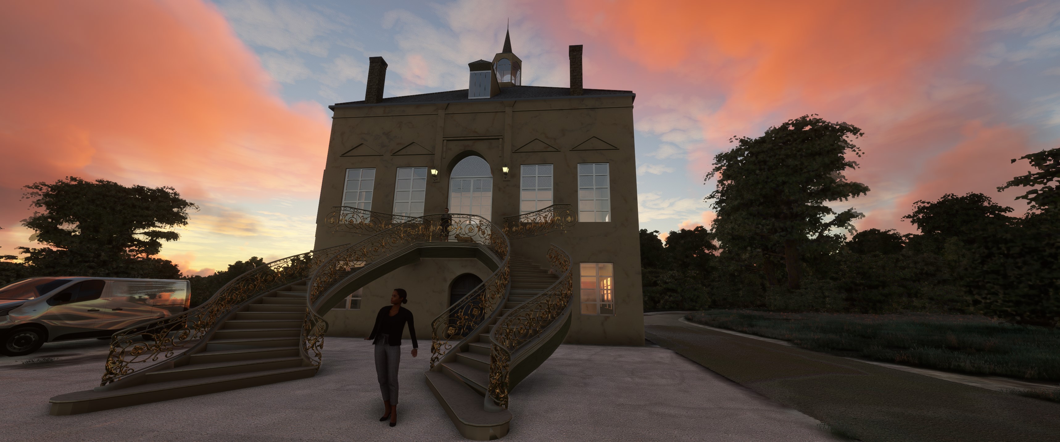
Updating the Château de Mirefleurs visible from the tarmac
Thanks to Alain for the photos
History
In 1936, Dr Seynat, president of the GTBA, was looking for land on the right bank of Bordeaux
to supplement the land on the left bank (Croix d'Hins, Beau Désert, Mérignac), landed with Mr Leroy
in Yvrac on a piece of farmland. After reaching an agreement with its owner, Mr Mackertich, the land
the land was leased and became an aeronautical platform with a North-South orientation of 600 m.
During the 39/45 war, the land was occupied by the German army, who built a blockhouse
a blockhouse and machine-gun mountings.
After the war, the destruction of the machine gun mountings and the blockhouse meant that the site could be restored to its former glory.
made it possible to resume aeronautical activities with only 450 m of runway.
The development of the site was made possible thanks to the intervention of the air bases
paratroopers and with the help of Dr Auriac, construction of the hangar
the construction of the 40 m x 20 m hangar, the clearing of more than 150 trees, and the work of cleaning up and
the ground. The track changed direction and became a 29/11 in 1951.
As for the club house, it was built thanks to the involvement and participation
The completed facility was inaugurated on 14 November 1954,
in the presence of the mayor of Yvrac, Anatole Blaise, and under the honorary presidency of Jacques Chaban Delmas,
then Minister for Transport and Mayor of Bordeaux.
Facilities
The airfield has a grass runway running east-west (11/29), 685 metres long and 602 metres wide.
The airfield is not controlled. Communications are self-information on the 119.950 MHz frequency.
There are also
a parking area
hangars
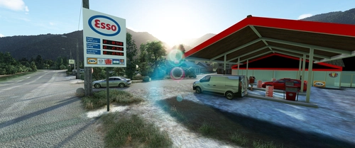
a refuelling station for fuel (100LL) and lubricants
a restaurant.
Huge thanks to Linou33500 for making me pictures of LFDY and to Colinj ,Moustache ,MichelVP,Totof,Ethnicfs, and EOL for sharing their libraries.
You'll need 6 libraries to see it all
Ethnicfs Vegetation library
https://fr.flightsim.to/file/56359/ethnicfs-vegetation-library
Ethnicfs Misc Scenery Objects
https://fr.flightsim.to/file/45163/ethnicfs-misc-scenery-objects
Animated Human 3D Models Library
https://fr.flightsim.to/file/33166/animated-humans-library
totof library object V5
https://fr.flightsim.to/file/17179/totof-library-object-v1-1
Emerald Object Library
https://emeraldscenerydesign.com/
https://fr.flightsim.to/file/8824/emerald-object-library
MSFS PBK Effects Scenery Library
https://flyawaysimulation.com/downloads/files/24887/msfs-pbk-effects-scenery-library/
laserjet©34
__________________________________________________________________________________________
Aérodrome de Bordeaux -LFDY-Yvrac V 1.0
L’aérodrome de Bordeaux - Yvrac (code OACI : LFDY) est un aérodrome agréé à usage restreint1,
situé sur la commune d’Yvrac à 7 km au nord-est de Bordeaux dans la Gironde (région Nouvelle-Aquitaine, France).
Il est utilisé pour la pratique d’activités de loisirs et de tourisme (aviation légère et aéromodélisme).
Altitude 74 m (244 ft)
LFDY-Yvrac V1.1
rectification du dénivelé de la piste merci a FS2020Newbie de me l'avoir signalé
rajout des balises des points d'arrêt signalé par Linou33500 merci a lu
LFDY-Yvrac V1.2
Mise a jours du Château de Mirefleurs visible du tarmac Merci a Alain pour les photos
Histoire
En 1936, le docteur Seynat, président du GTBA, à la recherche d’un terrain sur la rive droite de Bordeaux
pour compléter les terrains de la rive gauche (croix d’Hins, Beau désert, Mérignac), se pose avec Mr Leroy
à Yvrac sur un terrain agricole. Après des accords avec son propriétaire, Monsieur Mackertich, le terrain
est loué et deviendra une plateforme aéronautique avec une orientation Nord Sud de 600 m.
Pendant la guerre de 39/45, le terrain est occupé par l’armée allemande qui y construit
un blockhaus et des affuts de mitrailleuses.
Après la guerre, la remise en état, après la destruction des affuts et du blockhaus
a permis la reprise des activités aéronautiques avec seulement 450 m de piste
L’aménagement du site a pu être possible grâce à l’intervention des bases aériennes
et des militaires parachutistes et avec l’aide du Dr Auriac, construction du hangar
de 40 m x 20 m, dessouchage de plus de 150 arbres, travaux de nettoyage et de mise
en forme du terrain. La piste changera d’orientation pour devenir une 29 /11 en 1951.
Le club house verra, quant à lui, le jour grâce à l’intervention et la participation
de mécènes et à la bonne volonté des membres, le tout terminé est inauguré le 14 novembre 1954,
en présence du maire d'Yvrac Anatole Blaise et sous la présidence d’honneur de Jacques Chaban Delmas,
alors ministre des transports et maire de Bordeaux.
Installations
L’aérodrome dispose d’une piste en herbe orientée est-ouest (11/29), longue de 685 mètres et large de 602.
L’aérodrome n’est pas contrôlé. Les communications s’effectuent en auto-information sur la fréquence de 119,950 MHz.
S’y ajoutent,
une aire de stationnement
des hangars
une station d’avitaillement en carburant (100LL) et en lubrifiant
un restaurant.
Vous aurez besoins de 6 bibliothèques pour tout voir
Énormes Merci a Linou33500 de m'avoir faits des photos de LFDY et a Colinj ,Moustache ,MichelVP,Totof,Ethnicfs, et EOL pour leurs partages de bibliothèques
Ethnicfs Vegetation library
https://fr.flightsim.to/file/56359/ethnicfs-vegetation-library
Ethnicfs Misc Scenery Objects
https://fr.flightsim.to/file/45163/ethnicfs-misc-scenery-objects
Animated Human 3D Models Library
https://fr.flightsim.to/file/33166/animated-humans-library
totof library object V5
https://fr.flightsim.to/file/17179/totof-library-object-v1-1
Emerald Object Library
https://emeraldscenerydesign.com/
https://fr.flightsim.to/file/8824/emerald-object-library
MSFS PBK Effects Scenery Library
https://flyawaysimulation.com/downloads/files/24887/msfs-pbk-effects-scenery-library/
laserjet©34
Bordeaux LFDY-Yvrac
Discover the Bordeaux - Yvrac aerodrome (ICAO code: LFDY) located in Nouvelle-Aquitaine, France, featuring a grass runway and various facilities for leisure aviation activities. Explore the history and development of this aeronautical platform through different updates enhancing the scenery.


Supporters

User Reviews
13 reviews
Location
More Information
Version History
LFDY-Yvrac V1.2 Updating the Château de Mirefleurs visible from the tarmac Thanks to Alain for the photos LFDY-Yvrac V1.2 Mise a jours du Château de Mirefleurs visible du tarmac Merci a Alain pour les photos
Related
LFBX-Bassillac-Périgueux
Experience the detailed recreation of LFBX-Bassillac-Périgueux airport in this add-on. The airport features a paved runway with luminous beaconing and instrument approach systems, hosting various air activities annually. With hand-crafted buildings, updated features, and attention to detail, this mod offers a comprehensive enhancement to your flight simulation experience.
by laserjet34
LFCB Bagnères De Luchon
Enhance your Flight Simulator experience with the LFCB Bagnères De Luchon add-on, featuring a meticulously detailed recreation of Bagnères-de-Luchon aerodrome in France. This scenery includes key elements such as the LIDL, fire station, Gendarmerie, and Mr Bricolage, along with realistic urban furniture. Explore a grass runway, self-inform communications on 123.500 MHz, and the option for fuel and lubricant supply. Additionally, enjoy additional features like French flags, motorhomes, and emergency vehicles for a more immersive flying experience.
by laserjet34

Aérodrome de Montpellier - Candillargues
Enhance LFNG Candillargues in Microsoft Flight Simulator 2020 with updated buildings, vegetation, animals, decorations, and more. Includes a variety of models and features like signage, characters, and even pink flamingos. Requires download of nine additional libraries for full experience.
by laserjet34
LFDH Auch-Lamothe
Enhance your flight simulation experience with LFDH Auch-Lamothe Version 1.2. This add-on features detailed changes to buildings, characters, billboards, and traffic. Explore an updated environment with animated animals and vehicles, created with passion and attention to detail. Upon unzipping, this add-on offers 497 MB of new content for your virtual adventures in the skies.
by laserjet34
Comments(54)
Log in to join the discussion
Log Inabout 2 years ago
about 2 years ago
about 2 years ago
Thank you so much. This is an amazing scenery. There is so much to discover. Well done. I´m really loving it.
about 2 years ago
about 2 years ago
about 2 years ago
about 2 years ago
PD: Ugly to see those white stickers over the planes again xD https://flightsim.to/file/46419/get-rid-of-fix
about 2 years ago
over 2 years ago
bises, merci
over 2 years ago
une piste ??
over 2 years ago
il te manque
https://fr.flightsim.to/file/56359/ethnicfs-vegetation-library
over 2 years ago
https://fr.flightsim.to/file/56359/ethnicfs-vegetation-library
over 2 years ago
bises
over 2 years ago
over 2 years ago
over 2 years ago
over 2 years ago
over 2 years ago
Tous mes Voeux 2024
over 2 years ago