
Description
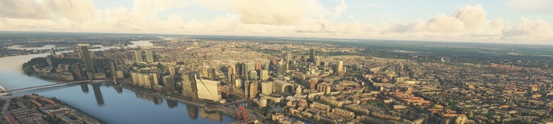
La Rochelle is a city in southwestern France and a seaport on the Bay of Biscay, a part of the Atlantic Ocean. It is the capital of the Charente-Maritime department.
The city is connected to the Île de Ré by a 2.9-kilometre (1.8-mile) bridge completed on 19 May 1988. Its harbour opens into a protected strait, the Pertuis d'Antioche.
La Rochelle possesses a commercial deep water harbour, named La Pallice. The large submarine pens built during World War II still stand there, although they are not in use. La Pallice is equipped with oil unloading equipment, and mainly handles tropical wood. It is also the location of the fishing fleet, which was moved from the old harbour in the centre of the city during the 1980s.
La Rochelle also maintains strong links with the sea by harbouring the largest marina for pleasure boats in Europe at Les Minimes, and a rather rich boat-building industry which includes Amel Yachts.
La Rochelle has a very big aquarium, and a small botanical garden (the Jardin des plantes de La Rochelle).
The Calypso, the ship used by Jacques-Yves Cousteau as a mobile laboratory for oceanography, and which was sunk after a collision in the port of Singapore (1996) is now on display (sadly rotting) at the Maritime Museum of La Rochelle.
One of the biggest music festivals in France, "FrancoFolies", takes place each summer in La Rochelle, where Francophone musicians come together for a week of concerts and celebration. 2004 marked the 20th anniversary of this event. The French Socialist Party has held its annual summer convention (Université d'été) in La Rochelle since 1983.
GPS: 46° 9′ 32.76″ N, 1° 9′ 6.12″ W
Credits:
This scenery has been extracted from Google Maps, hence all 3D credits goes to Google.
This scenery has been generated with the Google Earth Decoder tool (credits to /u/Jonahex111):
https://www.reddit.com/r/FS2020Creation/comments/j3faaj/google_earth_decoder_now_userfriendly/
OjO for the colorimetry
Addon history:
v1.0: initial release
What is the difference with the previous version ?
- better scenery blending with the MS/Asobo landscapes
- more autogen trees in the scenery, by using specific and accurate height maps (with a 5m precision)
- "laser-cut" tiles to keep only buildings and roads
If you want to donate, you will always be welcome to help me continue with more projects and update the existing ones https://paypal.me/Thalixte.
Comments(16)
Log in to join the discussion
Log Inabout 2 years ago
about 2 years ago
Très bon travail mais hélas, comme avec la scène précédente (celle de 1,12Go) des problèmes de couleur chez moi: les bâtiments apparaissent grisâtre (ils sont bien plus blanc dans la réalité) et surtout des artefacts au port des minimes (des routes apparaissent en rouge ).
over 3 years ago
Superbe travail ! Merci beaucoup :)
Cependant, j'ai noté un soulèvement du terrain/océan en forme de pyramide juste devant les deux tours du port. Est-ce un bug de mon simulateur ou cela vient-il du fichier ?
over 3 years ago
Bonsoir Thalixte
Merci pour votre superbe travail. Je vole depuis Fontenay et j'apprécie de voir La rochelle bien détaillée. Par contre quelle version choisir entre la 4.1 et la 2.0 ? Merci de votre retour Bonne soirée Benoit_MCR
over 3 years ago
Bonsoir. Comme indiqué dans la description, la V2.0 est mieux réalisée, car elle supprime quasiment tous les arbres de Google Earth pour les remplacer par des arbres autogénérés (c'est pourquoi je l'ai nommé V2.0)
La Rochelle City Enhanced
Explore the enhanced city of La Rochelle in southwestern France, with its historic seaport and vibrant maritime culture. This add-on features detailed scenery, including the iconic bridge connecting to Île de Ré and the commercial harbor of La Pallice. Immerse yourself in the citys rich nautical history, from the preserved submarine pens to the bustling marina and largest pleasure boat harbor in Europe. Experience the charm of La Rochelle with improved scenery blending, enhanced autogen features, and meticulous attention to detail.
User Reviews
6 reviews
Location
More Information
Version History
Adjust overall scenery altitude (fix airport heights)
Related
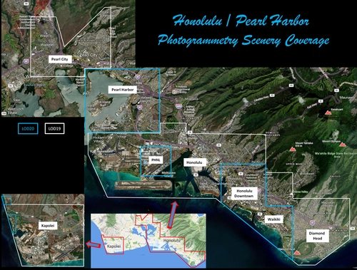
Honolulu
Explore the photogrammetry scenery of Honolulu, including the iconic Pearl Harbor area with optimized performance for better FPS. Discover Waikiki, Honolulu downtown, and more with this detailed addon. Enhance your experience by adding free mods for carriers, battleships, and military airplanes in Pearl Harbor and surrounding bases. Support the creator for future updates if you enjoy this mod.
by steveli
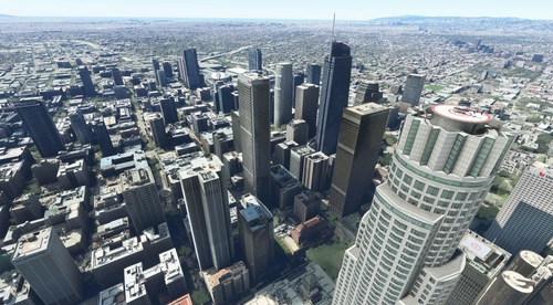
Downtown Los Angeles
Various buildings and monuments that are missing from Los Angeles in the game that shoudn't be. Wilshire Grand Center, SoFi Stadium, 801 S Grand, 825 S Hill, 888 S Hope, 1000 Grand, Apex the One, Atelier, Aven Apartments, Metropolis Towers, Level Los Angeles
by senecadriver
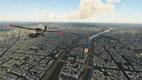
Paris
Explore the iconic cityscape of Paris in Microsoft Flight Simulator. This detailed add-on captures the essence of the French capital, featuring famous landmarks and architectural marvels. With accurate GPS coordinates, immerse yourself in the beauty of Paris, known for its historical significance and vibrant culture. Download now and experience the City of Light from a whole new perspective.
by Thalixte
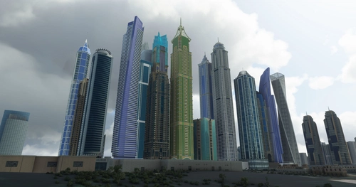
Dubai City Pack
Explore a detailed rendition of Dubai City and Jebbel Ali Port featuring over 250 custom buildings and various landmarks like the iconic hotels and tourist attractions. While focusing on enhancing the daytime visuals, this pack offers improved textures for select buildings, promising a refreshing experience for simmers. Additionally, adjustments have been made to SkyDive Dubai Airport to address previous elevation issues, ensuring a more immersive flight into this dynamic cityscape.
by risuali
over 1 year ago
Attention toutefois pour ceux qui envisageraient d'acheter la scène "LFBH - La Rochelle-Ile de Ré-Airport" de Simmarket, car cela provoque des problèmes de terrain sur le sud du parking avion et voiture (voir images). Mais bon, vu d'en haut, ça passe.