Description
French Alps - Department of Savoie (73) 1.0.0
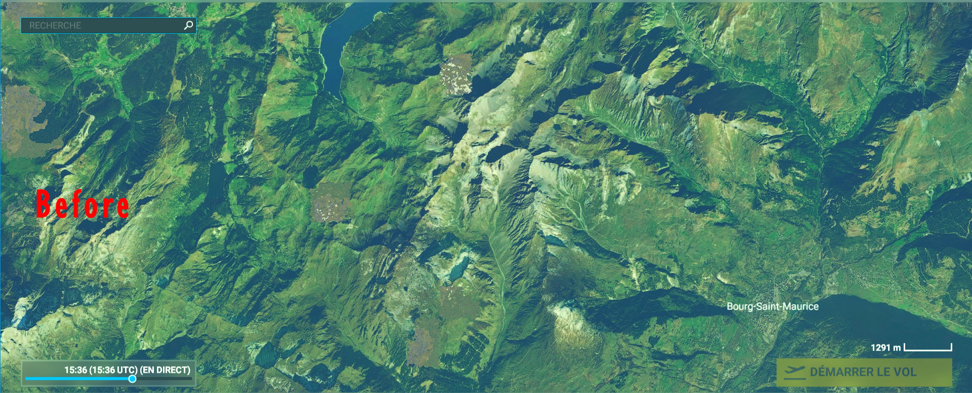
Since MSFS BingMap imagery is of poor quality, or even replaced by generic textures on some mountain ranges in the Savoie department (73), this supplement, produced with the source of the BD ORTHO® OpenData aerial photographs from IGN, makes it possible to correct this problem very advantageously. The resolution is 2.39 m (Lod16) around Chambéry and 1.29 m (Lod17) around Bourg-Saint-Maurice.
Installation: extract then copy and paste in your "Community" directory
Thanks to:
Microsoft
Asobo
MSFS Toolkit by Nool Aerosystems
Copyright: ftsxlw
ftsx.free.lw@gmail.com
Exclusively for free distribution and subject to the express authorization of the author.
Alpes Française - Département de Savoie (73) 1.0.0
L'imagerie BingMap de MSFS étant de mauvaise qualité, voire remplacé par des textures génériques sur quelques massifs montagneux du département de la Savoie (73), ce complément, réalisé avec la source des photographies aériennes BD ORTHO® OpenData de l'IGN permet de corriger très avantageusement ce problème. La résolution est de 2.39 m (Lod16) sur les alentours de Chambéry et de 1.29 m (Lod17) aux alentours de Bourg-Saint-Maurice.
https://fr.wikipedia.org/wiki/Savoie_(d%C3%A9partement)
Installation : extraire puis copier-coller dans votre répertoire « Community »
Merci à:
Microsoft
Asobo
MSFS Toolkit by Nool Aerosystems
Copyright : ftsxlw
ftsx.free.lw@gmail.com
Exclusivement pour diffusion gratuite et soumise à autorisation expresse de l’auteur.
French Alps - Department of Savoie (73) 1.0.0 (2)
Enhance the BingMap imagery in the Savoie department with this add-on utilizing BD ORTHO® OpenData aerial photographs from IGN. Enjoy improved textures with resolutions up to 1.29m around Bourg-Saint-Maurice. Installation is simple - extract and paste into your "Community" directory. Made for free distribution with authorization from the author.

User Reviews
1 reviews
Location
More Information
Version History
No version history available.
Related

Swiss mountains tree fix (trees on mountains removed)
A comprehensive mod fixing tree placement on Swiss mountains, particularly removing inaccurately placed trees on mountain peaks. The update includes a shift to more realistic conifer trees in the Alps and an expansion to border areas of France, Italy, and Austria. From Alpstein Säntis to Stockhorn, numerous locations across Switzerland have been meticulously corrected for a more authentic flight experience.
by THEOLI4D

Shorter Trees / Tree Height Modification VERSION 4.0 for MFS2020 (shorter, realistic trees)
Experience realistic and shorter trees in Microsoft Flight Simulator with the Shorter Trees / Tree Height Modification VERSION 4.0 add-on. Compatible with the latest version of MSFS, this mod provides adjusted tree heights for a more authentic flying experience. Update includes enhanced tree coloration blending seamlessly with photogrammetry trees. Installation is simple - just copy the folder into your community folder and enjoy a new perspective from the skies.
by ARIF STUDIOS - Adnan Arif

AUSTRIA 10m DEM - High Resolution Terrain Elevation Data from LIDAR Imaging
Explore the stunning terrain of Austria with this mod featuring high-resolution LIDAR data, offering a mesh resolution of 10m for a more realistic flight experience. Flatten lakes, rivers, and eliminate any terrain artifacts as you soar over the Austrian landscape. Divided into regions for convenience and performance optimization, this mod enhances the mountain shapes to mirror reality and provides a smoother flying experience. Experience Austria like never before with enhanced elevation data and realistic terrains.
by Troglodytus

SWITZERLAND 20m DEM - High Resolution Terrain Elevation Data from LIDAR Imaging
Explore the beauty of Switzerland with this mod offering high resolution terrain elevation data using LIDAR imaging. The mesh resolution is 20m, providing exceptional detail with a height resolution of 0.1m. Update includes extreme LIDAR meshes for specific regions. Please note potential performance impacts and report any bugs for further improvements. Fly VFR over Switzerland with enhanced realism and accuracy.
by Troglodytus
Comments(6)
Log in to join the discussion
Log Inalmost 3 years ago
over 4 years ago
Hello,
Thank you very much for your work.
But it seems to not working in VR mode. True?
over 4 years ago
over 4 years ago
Hello,
It's OK now. Some parameters modified for graphics in VR in the game and all is perfect. Sorry and thank you again for your great work. It's a beauty flying in VR over these landscapes.
Franck
over 4 years ago
it is necessary to copy the 3 files?
over 4 years ago
Yes of course !