
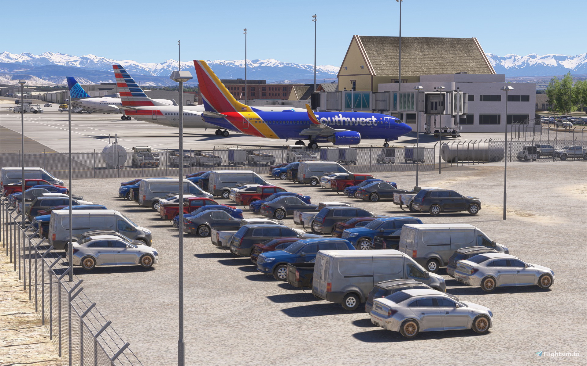
Description
Montrose Regional (KMTJ) in Montrose, Colorado, is served by United, Southwest, and American year-round, and Delta and Breeze seasonally. As one of the busiest airports on the Western Slope, winter is the most popular season with nearly a dozen nonstop flights offered on the four major airlines for skiers heading to Telluride. Two smaller general aviation airports in the region are also included in this package. Clifford Field (1CO4) in Olathe, Colorado, is one of the airports included in an MSFS career mission, and it is now properly aligned to the satellite image and curves down in the center. North Fork Valley Airport (7V2) in Paonia, Colorado, is primarily used by recreational aircraft and visitors doing business at the airport and in Paonia. The airport sits on an aircraft carrier-like plateau which is restored in this scenery. As you fly east, pairing these airports with my Colorado Seasons Enhanced scenery (though not required) will bring seasonal color changes to areas from Aspen down to Telluride. The upgraded airports remove/replace the default runway profiles and terraforming with new elevation data that restores the underlying terrain of airport, bringing back the real-world detail including everything from small drainage ditches to larger details like restored surrounding mountain terrains and canyons. Built with the SDK, MSFS library objects are assembled in a way to "look" like custom terminal buildings and more closely resemble their real-world counterparts, while not affecting framerates. Airport lighting, fencing, taxiway signs, markings, and layouts are updated based on most recent satellite imagery, YouTube videos, and/or first-hand knowledge of the location.
Windy Things is required to see the US and Colorado flags at KMTJ.
v1.2 Addresses the introduction of minor digital artifacts into KMTJ and 7V2 as a result of the new photogrammetry in "World Update 22: United States National Parks". As with all photogrammetry and airports, the advanced technology introduces challenges when applied to an area that did not previously have photogrammetry. (Please continue to report any new artifacts that might have been missed.) New satellite imagery blending and seasonal foliage in the WU22 update is a separate issue that will need further attention from the MSFS developers. The satellite/photogrammetry image functions as a single unit and takes priority over the underlying imagery, so for the best "seasonal" experience, the current best way to restore the previous satellite imagery and default seasonal foliage is to disable the “3D Photogrammetry Cities” section within the WU22 update. Just know that It will also disable a number of the detailed photogrammetry parks (including those in this quadrant) with it. ***Turning off photogrammetry "globally" is not recommended, as it will replace the underlying default "seasonal" foliage with year-round evergreens (conifers/pines).
Because AI aircraft behavior at non-towered airports is notoriously inconsistent (even with some external AI traffic injectors), a tower frequency (from the original Unicom) was added to KMTJ to handle commercial traffic. KMTJ airport should now function and communicate properly with ATC.
Updated airport beacons may sometimes appear higher than the actual beacon model when you begin (rather than complete) a flight at that airport. This is an inconsistent (and known) issue that occurs in the simulator and is not generated by the scenery itself. Runway "distance remaining" signs have yellow numbers instead of white, because the current SDK does not allow for white on a black background.
Dependencies
Location
KMTJ Montrose Regional (Colorado)
This add-on enhances Montrose Regional Airport KMTJ in Colorado, including updated terminal buildings, accurate runway profiles, and restored terrain detail using new elevation data. The package also features improvements for Clifford Field 1CO4 in Olathe and North Fork Valley Airport 7V2 in Paonia, reflecting their real-world layouts. Airport signage, lighting, and taxiway markings are brought up to date based on recent sources. Compatibility is maintained with seasonal scenery add-ons for a consistent regional experience.


User Reviews
1 reviews
Version History
v1.2 Addresses the introduction of minor digital artifacts into KMTJ and 7V2 as a result of the new photogrammetry in "World Update 22: United States National Parks". As with all photogrammetry and airports, the advanced technology introduces challenges when applied to an area that did not previously have photogrammetry. (Please continue to report any new artifacts that might have been missed.) New satellite imagery blending in the WU22 update is a separate issue that will need further attention from the MSFS developers. Currently, the only way to restore the previous satellite imagery is to either disable the “3D Photogrammetry Cities” section within the WU22 update or to turn off photogrammetry globally. However, doing so will also disable a number of the detailed parks (including those in this quadrant) with it. (7-7-26)
Related
KLRD Laredo International Airport (Texas)
This add-on accurately represents Laredo International Airport in Texas, updating the layout, taxiway system, and facilities to reflect recent changes. The airport is a key commercial and cargo hub near the US-Mexico border, with services from multiple passenger and cargo airlines. Terminal buildings and hangars are modeled using MSFS library objects for optimized performance. Lighting, signage, markings, and structures are updated based on current imagery and sources.
by csharpe
Colorado Seasons Enhanced & Mountain Airports
Colorado Seasons Enhanced corrects tree assignments to bring realistic aspen and cottonwood fall colors to Southwestern Colorado in Microsoft Flight Simulator, covering around 50 square miles. The add-on upgrades scenery for notable areas such as Kebler Pass, Maroon Bells, Telluride, and several custom airports, including Gunnison-Crested Butte Regional. Airports feature improved terrain, accurate markings, and updated terminal structures. Points of interest and seasonal foliage changes reflect the region’s unique landscapes, with recommended compatibility for enhanced season mods.
by Carlyle Sharpe
KBRO Brownsville/South Padre Island (Texas)
This add-on recreates Brownsville/South Padre Island International Airport in Texas with enhanced runway profiles, updated elevation data, and accurate terminal layouts. Utilizing default MSFS library objects, it closely represents the real-world airport while maintaining performance. The scenery reflects the latest taxiway signs, ground markings, and airport lighting based on up-to-date satellite imagery and local knowledge. The package also addresses typical SDK-related limitations in beacon placement and runway signage.
by csharpe
Log in to join the discussion
Log InComments(14)
2 months ago
2 months ago
4 months ago
4 months ago
4 months ago
3 months ago
4 months ago
4 months ago
4 months ago
4 months ago
4 months ago
4 months ago
4 months ago
In the meantime, did you try reenabling the default KSEA to see if KMTJ looked right? If not, you may want to do that to be doubly sure it is the cause. If KMTJ is an airport you'd like to keep using, and using the default KSEA restores KMTJ, let me know, and I may be able to make a custom KMTJ for you that substitutes that area with another library if none of the above suggestions fixes the issue while using the custom KSEA.
4 months ago
There is one more thing that you might try first, though. I read that if you rename the 3rd party software to the same name as the MSFS default, it should override the default airport without disabling its libraries. In this case, you would first copy the original MK Studios KSEA name somewhere as a backup, then rename that folder to "fs24-asobo-airport-ksea-seattle-tacoma". I figure it's worth a shot if it ends up working and you prefer the original KMTJ scenery. Please let me know if this works, and I'll add it to the notes. Thanks.