
Description
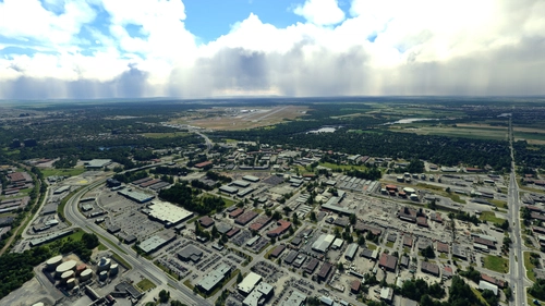
Aerial imagery for PHTO - Hilo International Airport exracted from Google Earth. While by no means perfect, this add-on aims to prevent pilots landing here from gouging their eyes out after seeing the default ground textures. This version of the scenery package contains a giant ground texture with georeferencing and some clutter. It is compatible with other PHTO airport or scenery.
Version history:
1.0:
- Initial version, Covers airport area and approaches.
1.1:
- Redone imagery to fix various stiching defects
- Updated area to cover more ugly terrain seen during approaches and removed some less useful sections
- Covered up some sections with grass and ground polygons to make the airport look prettier
- Added various 3D objects
- Makes PHTO a star airport on the world map
Installation:
Unzip and copy folder into your Community folder.
Full list of Hawaiian airports with enhanced aerial imagery:
PHNL: https://flightsim.to/file/50096/phnl-aerial-imagery
PHTO: https://flightsim.to/file/50127/phto-aerial-imagery
PHKO: https://flightsim.to/file/50617/phko-aerial-imagery
PHLI: https://flightsim.to/file/50760/phli-aerial-imagery
Thank you for any feedback and feel free to check out my NetDesign scenery:
https://www.facebook.com/profile.php?id=100089012365728
Comments(6)
Log in to join the discussion
Log Inover 1 year ago
almost 3 years ago
over 3 years ago
Thank you and i guess Maui airport is next? With some talents creating these scenery airport mods and some payware. Flying to these islands with your imagery, makes it fun flying on these fields. Keep em coming...
over 3 years ago
I don't intend to do the Maui one actually because there's a great payware airport that already has good ground textures. And if I make it only for the generic airport it will not be good with only updated ground imagery anyway. But check out PHKO, PHLI and PHNL.
over 3 years ago
Thank you so much for this! That and Honolulu.
Great work with this. Flying over the airport looks a lot better now.
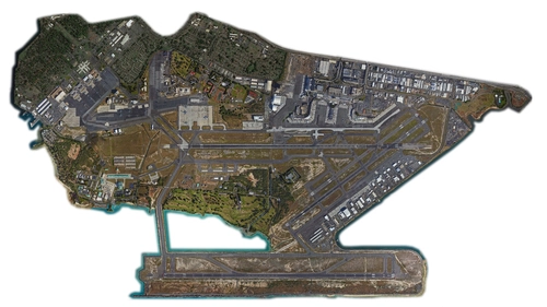
PHTO Aerial Imagery
Aerial imagery for PHTO - Hilo International Airport exracted from Google Earth. While by no means perfect, this add-on aims to prevent pilots landing here from gouging their eyes out after seeing the default ground textures. This version of the scenery package contains a giant ground texture with georeferencing and some clutter. It is compatible with other PHTO airport or scenery.
User Reviews
4 reviews
Location
More Information
Version History
- Redone imagery to fix various stiching defects - Updated area to cover more ugly terrain seen during approaches and removed some less useful sections - Covered up some sections with grass and ground polygons to make the airport look prettier - Added various 3D objects - Makes PHTO a star airport on the world map
Related
PHNL Aerial Imagery
Aerial imagery for PHNL - Daniel K. Inouye International Airport exracted from Google Earth. This add-on significantly improves the quality of the ground textures surrounding the Honolulu airport. This is a scenery package containing a giant ground texture with georeferencing and some scenery items. It is meant to be used with LimaJuliet and DanielK's PHNL scenery packages.
by Marionettework
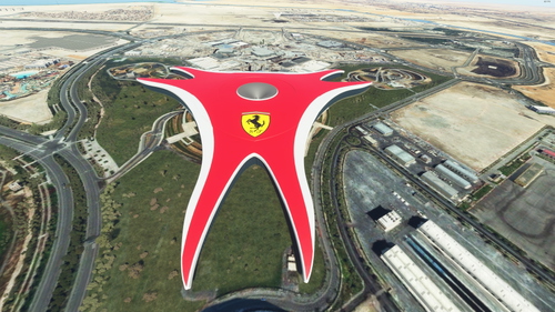
Ferrari World Abu Dhabi
A more accurate rendition of Ferrari World than the very disappointing auto-generated building. This scenery can be admired while taking off from runway 31 in OMAA. Some ground textures and vegetation was added to cover up bad aerial imagery. Includes night lighting.
by Marionettework
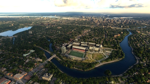
Ottawa Scenery
Ottawa, Ontario, Canada Scenery enhancement and fixes. Giving some much-needed help to Ottawa's badly outdated photogrammetry scenery, until Microsoft gets around to updating it. This version includes the completed Landsdowne Park redevelopment and fixes Ottawa's many transparent bridges. If I missed any let me know!
by Marionettework
Ottawa South Scenery
Update for Ottawa south scenery. There is no photogrammetry south of Hunt Club Rd by default, so this provides much nicer scenery during take off and approaches. The pack includes Merivale industrial park, Pineglen, Riverside South, Barrhaven east of Wodroffe and parts of the Rideau River.
by Marionettework
over 1 year ago