
Description
ETM 10m Azores Archipelago - Enhanced Terrain Mesh 10m for Azores Archipelago - version 1.1.0
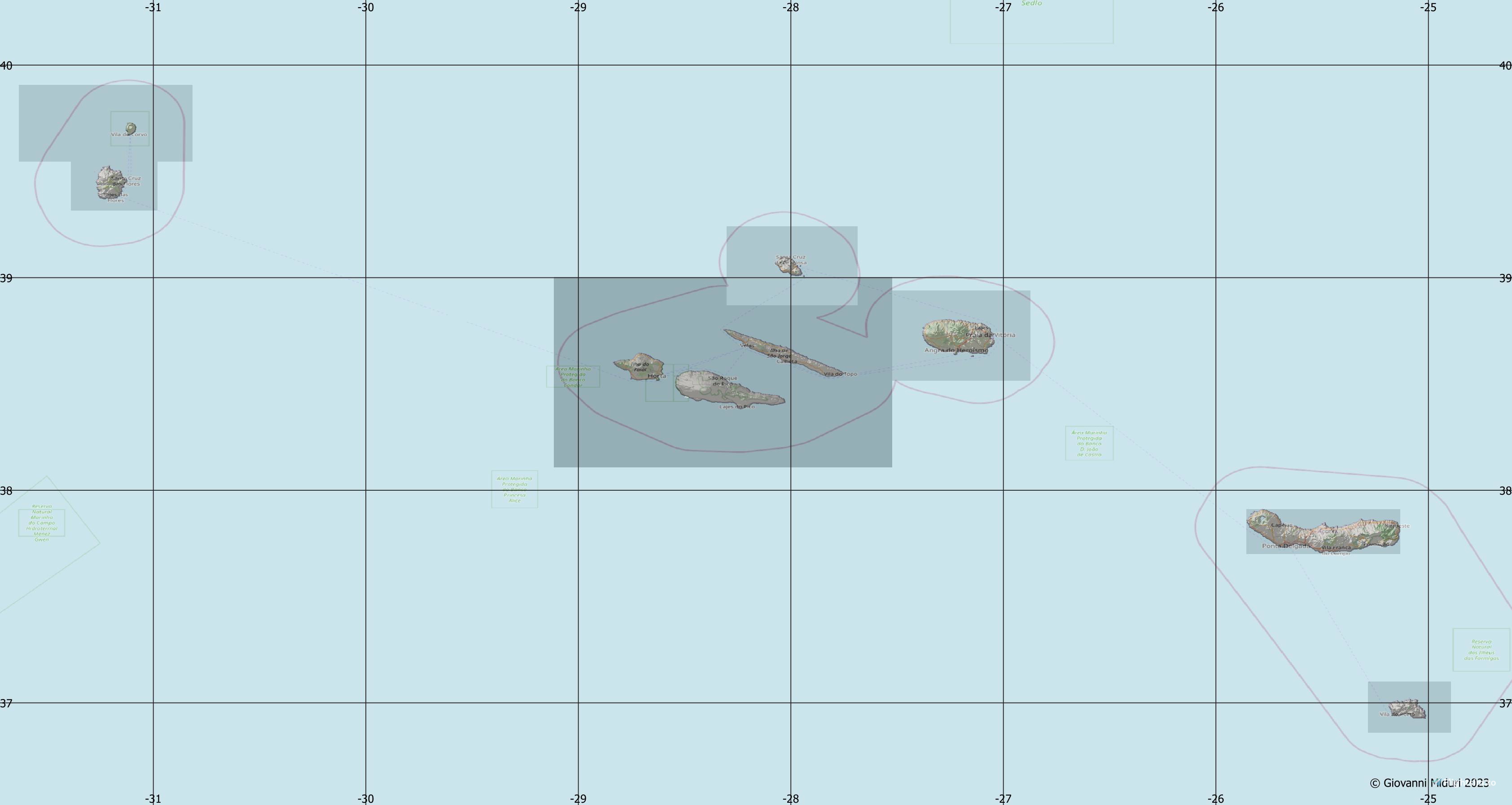
This is an Enhanced Terrain Mesh derived from Sentinel-1 mission of the European Radar Observatory for the Copernicus joint initiative of the European Commission (EC) and the European Space Agency (ESA), 0,365 arc sec (10 meters). Mainly the area covered by this terrain mesh is related to the region of ... see coverage map.
Affected Sceneries
Any large Payware and Freeware Airport I could think of, has been excluded from the mesh. So hopefully the glitches will be minimal. The coastline should be completely redesigned .... it could be the subject of a separate project.
Some airports (LPPD, LPAZ and LPLA) have been corrected to fit the new terrain mesh. Some in particular I corrected the taxiway names.
If you own a third party's LPPD scenario, then to avoid conflicts, you should not install LPPD_fix.bgl.
If you don't install LPPT_fix.bgl you need to update the layout.json file
with this https://github.com/HughesMDflyer4/MSFSLayoutGenerator
Completely remove previous version. Please report any bugs with sceneries or airports and I will see what I can do!
Created using MSFS Toolkit by Nool Aerosystems (MSFS Toolkit)
Enjoy your VFR flights above the Azores archipelago!
If you want, without obligation, you can offer me a coffee.
On Discord: ItalianCharter Team - Gjanosh61#9850
Dear virtual pilots,
After over 2,300 downloads and only 34 likes (1.5%), I have decided to temporarily suspend the download of this scenario. Not out of controversy, but for reflection.
This project was born from a deep passion for VFR flight and the desire to offer realistic and curated content to the community. However, the low response leads me to question the real interest in this type of work, which requires time, study, and dedication.
I sincerely thank everyone who appreciated, commented, or supported it. For those who would like to learn more or receive the full version, I remain available privately.
✉️ Contact:
Discord: ItalianCharter Team
Facebook: ItalianCharter Team
Flightsim.to: Gjanosh61
Thank you for your understanding, and happy flying everyone.
Frequently Asked Questions
Location
DEM / ETM10 Enhanced Terrain Mesh 10m for Azores Archipelago - version 1.1.0
Terrain mesh: The real-life world is not flat, it comprises mountains, valleys, rolling plains, etc. i.e. topographical features. These bumps, dips, and flat areas, all need to be translated into a surface understood by the simulator. A Digital Elevation Model (DEM).
Downloads Stopped
The creator has temporarily stopped downloads for this addon. Please check back later.

User Reviews
7 reviews
Version History
The cliffs of San Miguel and Santa Maria Island have been rebuilt.
Log in to join the discussion
Log InComments(27)
over 2 years ago
Do you have any more future plans for this?
over 2 years ago
over 1 year ago
over 2 years ago
over 2 years ago
almost 3 years ago
Happy new year. Muito sucesso e saúde
almost 3 years ago
almost 3 years ago
Today I installed your new version but I got the same issue as before having the LPPD MK Airport Scenery installed. There is still a great barrier on the Runway and a little cut in front of the terminal. I have a great interest to use your mesh so I discuss to buy the other Inibuilds scenery on the MSFS instead of the MK Scenery. Do you know if there s a different height structure? Is it eventually possible to make a userfriendly version for different Airport versions? That would be a great success.
I have no experience in mesh and scenery building so I cannot handle deeper changes in the system. Thank you very much!
Andreas
almost 3 years ago
For those who have additional third-party scenarios, the LPPD_fix.bgl file should not be installed. Everything is solved by updating the layout.json file.
For those like you who are not familiar with MSFS_SDK then I have prepared a version without fixes to install directly.
Before making it public, I would appreciate it if this version resolves the conflict with additional third-party scenarios.
I'll send you privately the link on my googledrive where you can download this version... with only the request for feedback,
almost 3 years ago
I’m very interested in your Pre Version to solve those issues with LPPD.
Awaiting your link to test it with third part Addons from LPPD. Thank you very much!🤩
almost 3 years ago
with this : https://github.com/HughesMDflyer4/MSFSLayoutGenerator
almost 3 years ago
almost 3 years ago
thanks for the feedback. as I already answered below, I don't have MKStudios LPPD installed. However, I would have appreciated a screenshot (view from above) of the point where you can see the step, perhaps highlighting it, after which I can attempt a correction to the DEM / ETM.
An on-the-fly modification that can be made to avoid conflict with MKStudio's LPPD is to delete the LPPD_fix.bgl file in the \Scenery folder
For the change to take effect you should update the layout.json file (via MSFSLayoutGenerator.exe) and report here whether the change took effect.
If you are on Discord, you can find me to continue there.
about 3 years ago
about 3 years ago
over 3 years ago
Its very nice!!! wish you could make a Mesh for a Pico Island Azores too
over 3 years ago
Hello ... now you can. Final version is out now. Completely delete the previous version.
over 3 years ago
Many thanks! Wish you could make a Mesh for Madeira too.
over 3 years ago
I certainly can. If you have a little patience ... I wanted to complete the Azores.
over 3 years ago
Many thanks for your reply and really looking forward to it and have (patience)!! Will you also then fix the levadas? There is already such a fix: https://flightsim.to/file/10860/madeira-fix-rivers-trees
Hope your version will be compatible with that fix - or not needed!?