Description
Falaise Monts d'Eraines, LFAS is a civil restricted use airfield located in Normandy.
Unpaved runway, 850x100m, QFU 06 / 24
A/A frequency is 123.18
In this scenery V0.9 :
_ Custom 3D models with photo textured
_ Improved runway profile (following VAC map)
This scenery is also available on simvol.org website ( https://www.simvol.org )
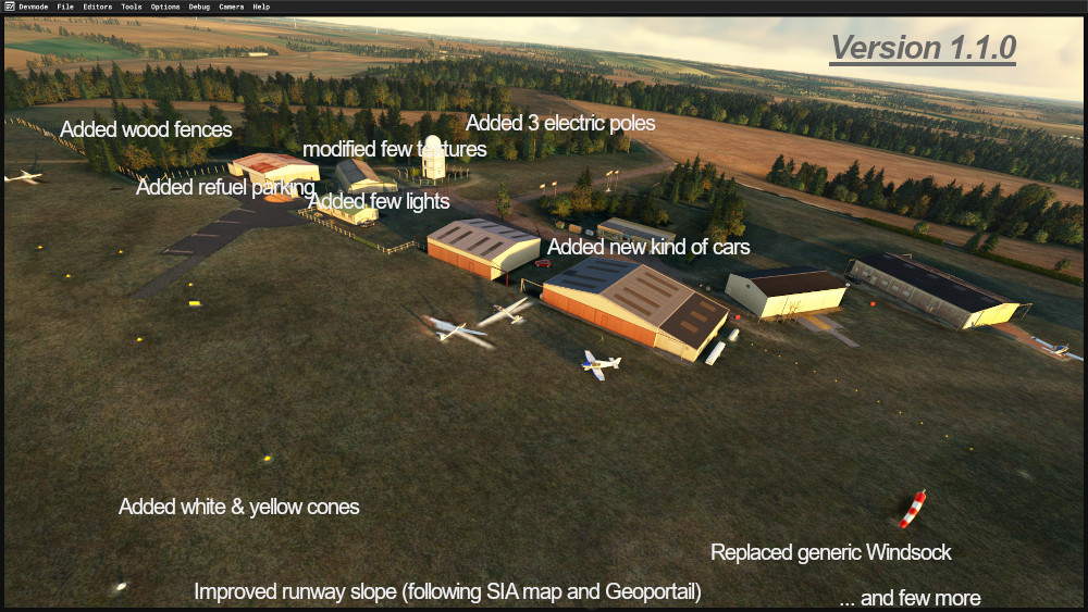
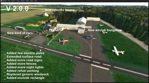
V1.1.0
_ Replaced generic Windsock
_Replaced generic Microsoft cars
_ Redraw few textures
_ Added some lights
_ Added few new 3D models I created (Electric poles, White & Yellow cones)
_ Added a Refuel parking area
_ Added few painted lines
_ Improved Runway slope following SIA chart & Geoportail imagery
To get third part misc 3D objects, it's better to download these following pakages
https://fr.flightsim.to/file/14024/windy-things
https://fr.flightsim.to/file/2549/edhk-lights-pack
https://fr.flightsim.to/file/17179/totof-library-object-v5
https://fr.flightsim.to/file/17182/totof-aircraft-library-v4
https://fr.flightsim.to/file/43395/ethnicfs-cars-library
https://fr.flightsim.to/discover/dave-s-3d-people-library
https://fr.flightsim.to/file/4696/dave-s-crooked-library
https://fr.flightsim.to/file/1923/mikea-at-assetpack
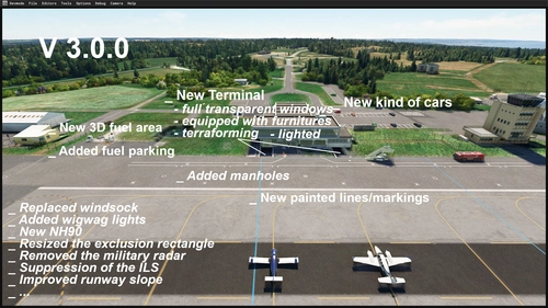
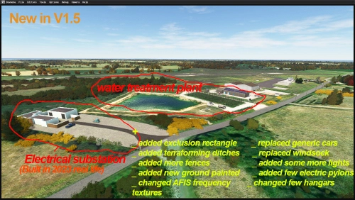
V1.0
_ Added 3 last hangars (3D blender and phototextred)
_ Added few road sign panels
_ Added exclusion rectangle
And thank you to Plouf099 andJean-Daniel for their photos
Have fun !
Comments(17)
Log in to join the discussion
Log In7 months ago
7 months ago
Bon courage et merci encore.
9 months ago
over 2 years ago
Also here many Thx from Warstein in Germany for this wonderfull, authentic and very detailed place to fly
about 3 years ago
Bonsoir. J4ai appris à voler sur ce terrain il y a pas mal d'années, j'ai un soucis avec le terrain sur msfs 2020 , la piste est bombée au point que depuis la piste on voit le toit des hangars . J'ai une connexion adsl limitée, donc je ne peux pas jouer en téléchargeant en direct les maps. Comment améliorer cette situation? Puis je télécharger un fichier avec les altitudes plus précises?
Le travail de modélisation du terrain est vraiment top. Merci beaucoup
about 4 years ago
Hi, lovely scenery but your version 0.9 appears to have an incorrect data file from an old SDK, which causes a conflict at MYNN (chequered box or large '11' sign') any chance of an update to resolve this?
https://forums.flightsimulator.com/t/mynn-strange-signs-at-the-airport/382128/52?page=3
about 4 years ago
Hi, I just checked with and without mu two sceneries LFAS and LFAJ and I got still got the same trouble of a big box (coming from the SDK 3d model). Also that could another scenery who do this trouble. I will have a deeper check later, certainly not before octobre (during summer I don't do anything for MSFS), I will have to add some others hangars and I will see in the same time.
Have good flights
over 4 years ago
Very nice, thank you.
over 4 years ago
bonjour, merci cette réalisation,ces petits aérodromes sont très sympa pour le vfr
over 4 years ago
Petit vol ce soir entre Flers et Falaise ,superbe réalisation de votre part. Merci.
over 4 years ago
Looks wery good what you have done. Really. For the three missing Hangars there are many video of this airport on YouTube,not good quality but you can see the hangars from far away. Try this ones. https://www.youtube.com/watch?v=8HmDkWjdoaw, https://www.youtube.com/watch?v=3URaA6SBILo, youtube.com/watch?v=3URaA6SBILo , Thanks.
over 4 years ago
Thank you for these video link, always beautiful to see planes in the air or take off or land, but for 3D modelling there are not enough details. Have fun
over 4 years ago
Top notch work.looks very nice.
over 4 years ago
Superbe Yves, un grand merci pour la scène de Falaise très réaliste
LFAS Falaise Monts d'Eraines V1.1
Explore LFAS Falaise Monts dEraines V1.1, a civil restricted use airfield in Normandy with an unpaved runway and custom 3D models. Version 1.1 features improvements like new 3D models, lights, and a refuel parking area. Enhance your scenery with third-party objects available for download.
User Reviews
5 reviews
Location
More Information
Version History
V1.1.0 _ Replaced generic Windsock _Replaced generic Microsoft cars _ Redraw few textures _ Added some lights _ Added few new 3D models I created (Electric poles, White & Yellow cones) _ Added a Refuel parking area _ Added few painted lines _ Improved Runway slope following SIA chart & Geoportail imagery
Related
LFRC Cherbourg Manche (Maupertus)
Explore LFRC Cherbourg Manche (Maupertus), a civil/military airport in Normandy featuring a paved runway, approach lights, and AFIS. This scenery overhaul includes a reworked terminal, new 3D models, animated humans, and historical background on the airports development and operations.
by YvesP6
LFOP - Rouen Vallée de Seine
Explore LFOP - Rouen Vallée de Seine, a detailed representation of a civil airport in Normandy, located 9kms east of Rouen. This scenery features a paved runway, ILS DME, Papi lights, and grass runway, providing a realistic flying experience. Learn about the airports history and its significance as a hub for regional companies and private jets.
by YvesP6
LFEA - Belle ile airfield.zip
Discover the charm of Belle-Ile aerodrome in Brittany, France. Version 1.5 features enhanced 3D models, runway improvements, and added details like lighting and electric pylons. Explore this scenic airfield and its rich history, dating back to its establishment in 1954.
by YvesP6
LFOS - Saint Valery Vittefleur.zip
Explore the civil airfield of Saint Valery Vittefleur, LFOS in Normandy with its unpaved runway and unique features. Be cautious of aircraft movements near the CD68 road and the nearby nuclear power plant. Experience the history of this airfield once used by German and American Air Force during the sixties.
by YvesP6
7 months ago
Peut-on espérer une version MSFS2024 de votre superbe scène de LFAS ?
Par avance, un grand merci !