Description
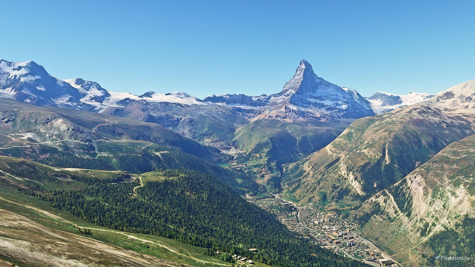
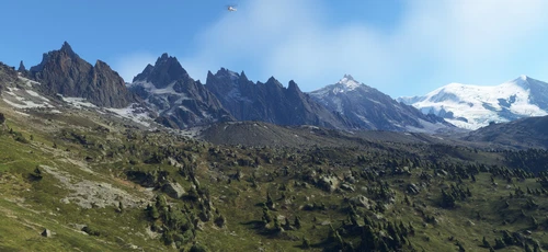
At last, Matterhorn mountain scenery, because the default one looked underwhelming and did no justice to this extremely beautiful natural wonder. Fully photogrammetry based model and terraformed edges around the mountain + new additions arround the area.
Info:
****** AS OF UPDATE #7 (FS2020) (1.11.6.0) OF 30TH OF NOVEMBER 2020 , MATTERHORN FLOATS ABOVE THE TERRAIN AFTER ASOBO UPDATED THE WORLD DEM TERRAIN DATA. I WILL RELEASE AN UPDATED FILE WITH THIS ISSUE FIXED AS SOON AS POSSIBLE.
Lately work is a pressing task for me and not having the room needed to make these updates possible on time, is the reason why some updates are "lagging" for a prolonged period of time. Thank you for being patient. ******
Matterhorn, the Swiss and incredibly photogenic giant. Famous around the world, this mountain is a beauty. That's why I took the challenge to "renovate" the original one of the game, that looked lacking. Matterhorn figure is very difficult to be interpreted successfully in the sim with low resolution mesh data, it needed a really high resolution model. This is what it is.
With Version 2.0 there are new additions, like :
- Added 4 LOD levels and improved performance when flying far from the mountain or when viewing it from certain angles.
- Color corrected the textures as much as possible and totally removed the default bluish shadows to make it look natural and beautiful.
- Added cable car pylons for the whole area. Now it's more interesting to explore around the mountain following their path.
- Added polygons for the missing forests south of Zermatt near the foothills of the mountain. Now they are properly populated with trees.
*Also, the older Version 1.0 will always be available in Nexusmods.com in the "Files" section.
There are KNOWN ISSUES such as : - May cause severe fps drops on higher resolution displays. - You can pass beneath the artificial ground of the model because terrain mesh is not accurate,so no collision for the most part. -There are also some artifacts at the edges of the scenery(i tried to cover up most of them somehow) and my theory is that they were created during the injection of the model in blender.
How to Install: Drag and drop the folder from the .zip , in your "Community" folder. That's it, enjoy!!
*Also make sure to check out my other addon, the little grass airstrip of Chamois, south and very close to the mountain! Landing there is a challenge! Link: https://flightsim.to/file/326/airport-of-chamois-ao02-valle-d-aosta
Trivia: The Matterhorn (/ˈmætərhɔːrn/, German: [ˈmatərˌhɔrn]; Italian: Cervino [tʃerˈviːno]; French: Cervin [sɛʁvɛ̃]) is a mountain of the Alps, straddling the main watershed and border between Switzerland and Italy. It is a large, near-symmetric pyramidal peak in the extended Monte Rosa area of the Pennine Alps, whose summit is 4,478 metres (14,692 ft) high, making it one of the highest summits in the Alps and Europe.The four steep faces, rising above the surrounding glaciers, face the four compass points and are split by the Hörnli, Furggen, Leone/Lion, and Zmutt ridges. The mountain overlooks the Swiss town of Zermatt, in the canton of Valais, to the north-east and the Italian town of Breuil-Cervinia in the Aosta Valley to the south. Just east of the Matterhorn is Theodul Pass, the main passage between the two valleys on its north and south sides, and a trade route since the Roman Era.The Matterhorn was studied by Horace-Bénédict de Saussure in the late eighteenth century, who was followed by other renowned naturalists and artists, such as John Ruskin, in the 19th century. It remained unclimbed after most of the other great Alpine peaks had been attained and became the subject of an international competition for the summit. The first ascent of the Matterhorn was in 1865 from Zermatt by a party led by Edward Whymper; it ended when four of its seven members fell to their deaths on the descent. This disaster, later portrayed in several films, marked the end of the golden age of alpinism. The north face was not climbed until 1931 and is among the three biggest north faces of the Alps, known as "The Trilogy". The west face, which is the highest of the Matterhorn's four faces, was completely climbed only in 1962. It is estimated that over 500 alpinists have died on the Matterhorn, making it one of the deadliest peaks in the world.The Matterhorn is mainly composed of gneisses (originally fragments of the African Plate before the Alpine orogeny) from the Dent Blanche nappe, lying over ophiolites and sedimentary rocks of the Penninic nappes. The mountain's current shape is the result of cirque erosion due to multiple glaciers diverging from the peak, such as the Matterhorn Glacier at the base of the north face. Sometimes referred to as the Mountain of Mountains (German: Berg der Berge),the Matterhorn has become an iconic emblem of the Alps in general. Since the end of the 19th century, when railways were built in the area, the mountain has attracted increasing numbers of visitors and climbers. Each year, numerous mountaineers try to climb the Matterhorn from the Hörnli Hut via the northeast Hörnli ridge, the most popular route to the summit. Many trekkers also undertake the 10-day-long circuit around the mountain. The Matterhorn has been part of the Swiss Federal Inventory of Natural Monuments since 1983.
Comments(100)
Log in to join the discussion
Log Inover 3 years ago
Great!!!
over 3 years ago
Ce magnifique Matterhorn nous manque terriblement... Quand pourra-t-on le revoir ainsi alors que sa représentation dans la version Asobo est affreuse...!!!
over 3 years ago
"****** AS OF UPDATE #7 (FS2020) (1.11.6.0) OF 30TH OF NOVEMBER 2020 , MATTERHORN FLOATS ABOVE THE TERRAIN AFTER ASOBO UPDATED THE WORLD DEM TERRAIN DATA. I WILL RELEASE AN UPDATED FILE WITH THIS ISSUE FIXED AS SOON AS POSSIBLE."
Two years later... did you completely abandon the project?
over 4 years ago
no compatible with MAJ mfs
over 4 years ago
dosent work in sum 7 ........ ;(((((
over 4 years ago
Compatibility with Sim Update 6 has not worked yet
almost 5 years ago
Still waiting for the update :/ to fix the elevation problem.
almost 5 years ago
Just think that I have also seen the same mountain in Italy (and I have also been there to ski). But if you only put the flag of Switzerland then I think I was wrong.
almost 5 years ago
The terrain is floating :(
about 5 years ago
Thank you for your Impressive scenery.
Impressed by the real mountains, I made a video of about 16 minutes. Please have a look if you like.
over 5 years ago
over 5 years ago
over 5 years ago
I created a new one from scratch and posted it here: https://flightsim.to/file/7564/matterhorn
The elevation has been adjusted to match the new model.
over 5 years ago
over 5 years ago
works. Thanks
over 5 years ago
Ther eis a second mod with the mountain here:
https://flightsim.to/file/3055/boeing-a320-kurdish-air-91-now
I will test it doday.
over 5 years ago
thanks a lot. with the one you mentioned it works perfectly. Many Thanks and all the Best.
Matterhorn Mountain
Explore the stunning beauty of Matterhorn mountain with this add-on, featuring a fully photogrammetry-based model and terraformed edges for a more realistic experience. Version 2.0 includes new additions such as improved LOD levels, color-corrected textures, cable car pylons, and populated forests. Install by dragging the folder into your "Community" folder and enjoy the enhanced scenery around this iconic peak.

User Reviews
36 reviews
Location
More Information
Version History
- Added 4 LOD levels and improved performance when flying far from the mountain or when viewing it from certain angles. - Color corrected the textures as much as possible and totally removed the default bluish shadows to make it look natural and beautiful. - Added cable car pylons for the whole area. Now it's more interesting to explore around the mountain following their path. - Added polygons for the missing forests south of Zermatt near the foothills of the mountain. Now they are properly populated with trees. More details : I divided the mountain into 4 different distinct model areas. It may need some tweaking and a larger number of divisions for better performance gains on larger resolution displays or even some model tweaking in Blender. Now the mountain can look a little weird when transitioning between different levels of detail, or from afar when zoomed in, a drawback of having LODs. Also, the older version 1.0 will always be available in Nexusmods.com in the "Files" section.
Related
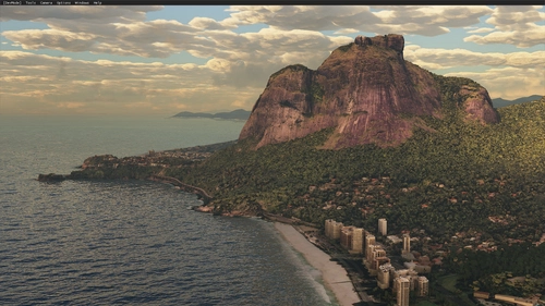
Rio de Janeiro Megapack Montanhas
Explore the detailed mountainous landscape of Rio de Janeiro in this updated megapack. Precisely positioned mountains like Pedra da Gávea and Pão de Açúcar using Google Maps models. Create your mod via Earth2MSFS for an effective import process. Stay tuned for further updates with optimized textures and added landmarks. Individualize your experience by adding specific mountain ranges to enhance your simulation.
by RodrigoMoraes94
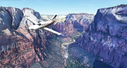
Zion Canyon National Park, Utah
Explore the breathtaking beauty of Zion Canyon National Park in Utah with this V1.0 scenery add-on. Discover well-known locations like the Zion Canyon Overlook, Angels Landing, and more. Experience corrected terrain heights and improved color blending for a more immersive flight simulation. Simply extract the file to your Community Folder and start your aerial adventure in this stunning national park.
by Jeppeson2001
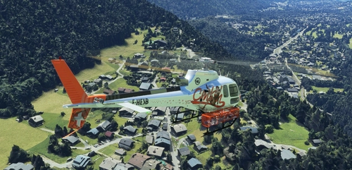
Chamonix-Mont-Blanc, Rhône-Alpes, France - Valley
Explore the stunning Chamonix-Mont-Blanc valley in Rhône-Alpes, France with this addon, including a semi-fictional DZ at Argentière. Enhance your experience by combining it with the Mountains addon. Download, extract into community folder, and enjoy photogrammetry and object data. This addon requires a minimum configuration for optimal performance.
by AdrianL
Chamonix-Mont-Blanc, Rhône-Alpes, France - Mountains
Explore the stunning Chamonix-Mont-Blanc mountain scenery in Rhône-Alpes, France with this mod. Includes photogrammetry and terraforming data for a realistic experience. Additional files are available for extension and customization. Check system requirements before downloading for optimal performance.
by AdrianL
about 3 years ago
hello does this work with the dlc where you can buy it where the hörndlihütte is in it today ?????