Description
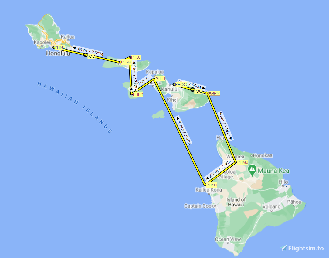
Visiting the nine airports listed on the Mokulele Airlines website, this route is 283 nautical miles around the Hawaiian islands. I’ve included the flight plan in both MSFS (.pln) and Little Navmap (.lnmpln) formats. The safe altitude for flight is 6,500 feet.
Rob54613 has recreated two Mokulele Airlines’ Grand Caravan liveries. Download them here and here. I've linked the sole airport add-on I have in the route below. That one is freeware; there may be more at payware level.
We start at Kahului (PHOG), on Maui, where the airline is based, and head 24 nm east, over the Koolau Forest Reserve, to Hana (PHHN), then south for 51 nm, over the Maui Channel and the 5,500-foot Kohala mountain, onto Hawai’i for stops at Waimea-Kohala (PHMU) and Kona International (PHKO). We then return to Maui, flying over West Maui Forest Reserve, for a stop at Kapalua (PHJH) on the western edge of the island. From there, it’s southwest to the airport of the island of Lana'i (PHNY). Turning north, we fly on to Moloka’i for stops at Kalaupapa (PHLU) and Molokai'/Hoolehua (PHMK). From there, our final destination is Honolulu International (PHNL) on O’ahu.
Comments
Log in to join the discussion
Log InNo comments yet. Be the first to share your thoughts!
Mokulele Airlines Hawaiian flight plan
Explore a 283 nautical mile flight plan around the Hawaiian islands, visiting nine airports with this add-on. Includes flight plans in MSFS and Little Navmap formats, as well as two Mokulele Airlines Grand Caravan liveries. Fly over stunning landscapes and enjoy a detailed recreation of the route.

More Information
Version History
No version history available.
Related
Zurich (LSZH) real Swiss Airlines passenger routes
Explore 79 of the 80 real Swiss Airlines passenger routes departing from Zurich Airport, ranging from high-altitude IFR to low-altitude flights. Experience realistic flight times and challenging landings at various destinations, including London City Airport with its short runway. Load your selected route easily and start your journey from the gate or runway in Microsoft Flight Simulator.
by newtestleper

Stockholm Arlanda (ESSA) real Scandinavian Airlines passenger routes
Experience all 58 Scandinavian Airlines routes from Stockholm Arlanda, including destinations across Europe and the United States. Choose between high-altitude IFR and low-altitude flights, simulating realistic passenger routes. Load your preferred route in Microsoft Flight Simulator and select your starting point for an authentic flying experience.
by newtestleper
YSSY (Sydney) real Jetstar passenger routes
Explore all 24 high-altitude IFR Jetstar passenger routes departing from YSSY in Sydney, Australia. From Adelaide to Townsville, experience long-haul flights with livery options available for A320 and A321 aircraft. Load your selected route easily and start from your desired gate for a realistic flying experience.
by newtestleper
I-90 coast-to-coast flight plan
Embark on a cross-country journey from Boston to Seattle following the iconic Interstate 90, covering 12 states and totaling 2,818 miles. This detailed flight plan offers 22 legs with default scenery for each airport and is available in MSFS and Little Navmap formats. Explore diverse landscapes and elevation changes, offering a unique and scenic flying experience.
by newtestleper