


ESTRADA REAL
A Estrada Real é a maior rota turística do país. São mais de 1.630 quilômetros de extensão, passando por Minas Gerais, Rio de Janeiro e São Paulo. Hoje, ela resgata as tradições do percurso valorizando a identidade e as belezas da região.
A sua história surge em meados do século 18, quando a Coroa Portuguesa decidiu oficializar os caminhos para o trânsito de ouro e diamantes de Minas Gerais até os portos do Rio de Janeiro. As trilhas que foram delegadas pela realeza ganharam o nome de Estrada Real.
Neste post trago a rota "Caminho Velho"
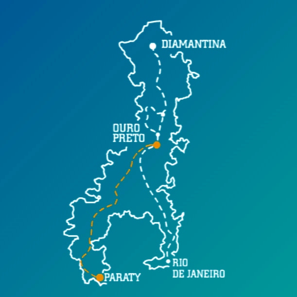
CAMINHO VELHO
Também chamado de Caminho do Ouro, foi o primeiro trajeto determinado pela Coroa Portuguesa e liga Ouro Preto a Paraty.
Foi a primeira via aberta oficialmente pela Coroa Portuguesa para ligar o litoral fluminense à região produtora de ouro no interior de Minas Gerais. Na época, no século 17, o percurso levava 60 dias para ser feito pelos tropeiros a cavalo.
ROTAS: 27
DISTÂNCIA: 710 KM
Com muitas histórias para contar, o Caminho Velho foi a primeira via aberta oficialmente pela Coroa Portuguesa para o tráfego entre o litoral fluminense e a região mineradora.
São localidades de cultura típica de Minas Gerais, um combinado entre as raízes indígenas, africanas e europeias. Essa riqueza é responsável por atrativos como a arquitetura única de Ouro Preto, a gastronomia reconhecida internacionalmente de Tiradentes, as grandes estâncias hidrominerais do Circuito das Águas e a cultura latente de Paraty.
Os 710 km do Caminho Velho são divididos em 27 planilhas, onde em cada um dos trechos o turista terá a possibilidade de viver boas experiências. Dos 710 quilômetros 10% estão asfaltados (75,5 km), 1,5% de calçamento (10 km) e 6% de trilha (38 km). Os outros 82,5% são de estrada de terra (586,5 km)
Trecho de asfalto ou trilha
Ouro Preto – São Bartolomeu = 18 km de trilha
São Bartolomeu – Glaura = 3 km de trilha
Glaura – Cachoeira do Campo = 7,5 km de asfalto
Cachoeira do Campo – Santo Antônio do Leite = 5 km de asfalto
Pequeri – São Brás do Suaçuí = 3 km de trilha
Lagoa Dourada - Prados = 3 km de trilha
Tiradentes – São João del-Rei = 10 km de calçamento
São João del-Rei – São Sebastião da Vitória = 11 km de trilha
Capivari - Itamonte = 4,5 Km de trilha
Passa Quatro - Garganta do Embaú = 1 km de trilha
Garganta do Embaú – Vila do Embaú = 10 km de asfalto
Vila do Embaú – Guaratinguetá = 7 km de asfalto
Guaratinguetá – Cunha = 22 km de asfalto
Cunha – Paraty = 24 km de asfalto *
O turista tem que ficar muito atento no campo de observações das planilhas, principalmente nos trechos de trilha, onde ele terá informações do estado da trilha e a possibilidade de fazê-la, como por exemplo, se tem como percorrê-la com alforje, além de informações de como é possível evitá-las. Dentre as trilhas de grande dificuldade está a que liga Ouro Preto a São Bartolomeu.
Para quem vai percorrer no sentido Ouro Preto – Paraty terá a altimetria a seu favor, pois ela sai de 1.200 metros para o nível do mar. Mesmo assim o percurso todo oscila com subidas curtas e longas, num total de 320 quilômetros, sendo as mais marcantes entre Capela do Saco e Carrancas e entre Guaratinguetá e Cunha. Em boa parte dos percursos existe poucas opções com áreas sombreadas, principalmente entre São João del-Rei e Cruzília.
Para quem vai percorrer no sentido Paraty – Ouro Preto terá a altimetria como inimigo, pois ela sai do nível do mar para 1.200 em Ouro Preto. Mesmo assim, o percurso todo oscila com subidas curtas e longas, num total de 319 km, sendo as mais marcantes entre Paraty e Cunha, Vila do Embau e Passa Quatro e São Bartolomeu e Ouro Preto.
Bons voos.
https://institutoestradareal.com.br
----------------------------------------------------------------------
THE ROYAL ROAD
The Royal Road is the largest tourist route in the country, spanning over 1,630 kilometers through the states of Minas Gerais, Rio de Janeiro, and São Paulo. Today, it revives the traditions of the route, emphasizing the identity and beauty of the region.
Its history dates back to the 18th century when the Portuguese Crown decided to formalize the paths for the transit of gold and diamonds from Minas Gerais to the ports of Rio de Janeiro. The trails delegated by the royalty were named the Royal Road.
In this post, I bring you the "Caminho Velho" (Old Path).
OLD PATH
Also known as the Gold Path, it was the first route determined by the Portuguese Crown, connecting Ouro Preto to Paraty.
It was the first route officially opened by the Portuguese Crown to connect the Rio de Janeiro coast to the gold-producing region in the interior of Minas Gerais. At that time, in the 17th century, the journey took 60 days for horseback-riding muleteers.
ROUTES: 27 DISTANCE: 710 KM With many stories to tell, the Old Path was the first route officially opened by the Portuguese Crown for traffic between the Rio de Janeiro coast and the mining region.
There are places with typical Minas Gerais culture, a blend of indigenous, African, and European roots. This richness is responsible for attractions such as the unique architecture of Ouro Preto, the internationally recognized cuisine of Tiradentes, the large hydro-mineral estates of the Circuito das Águas, and the vibrant culture of Paraty.
The 710 km of the Old Path are divided into 27 stages, where in each section, the tourist will have the opportunity to have great experiences. Of the 710 kilometers, 10% are paved (75.5 km), 1.5% are cobblestone (10 km), and 6% are trails (38 km). The remaining 82.5% are dirt roads (586.5 km).
Asphalt or trail sections:
Ouro Preto – São Bartolomeu = 18 km trail
São Bartolomeu – Glaura = 3 km trail
Glaura – Cachoeira do Campo = 7.5 km asphalt
Cachoeira do Campo – Santo Antônio do Leite = 5 km asphalt
Pequeri – São Brás do Suaçuí = 3 km trail
Lagoa Dourada - Prados = 3 km trail
Tiradentes – São João del-Rei = 10 km cobblestone
São João del-Rei – São Sebastião da Vitória = 11 km trail
Capivari - Itamonte = 4.5 km trail
Passa Quatro - Garganta do Embaú = 1 km trail
Garganta do Embaú – Vila do Embaú = 10 km asphalt
Vila do Embaú – Guaratinguetá = 7 km asphalt
Guaratinguetá – Cunha = 22 km asphalt
Cunha – Paraty = 24 km asphalt *
Travelers need to pay close attention to the observations in the sheets, especially in trail sections, where they will find information about the trail's condition and the possibility of traversing it. For example, if it's possible to navigate it with saddlebags, as well as information on how to avoid them. One of the trails of great difficulty is the one that connects Ouro Preto to São Bartolomeu.
For those traveling from Ouro Preto to Paraty, the altitude works in their favor, as it descends from 1,200 meters to sea level. Still, the entire route fluctuates with short and long ascents, covering a total of 320 kilometers, with the most remarkable ones between Capela do Saco and Carrancas and between Guaratinguetá and Cunha. In much of the route, there are few options with shaded areas, especially between São João del-Rei and Cruzília.
For those traveling from Paraty to Ouro Preto, the altitude is an adversary, as it ascends from sea level to 1,200 meters in Ouro Preto. Nonetheless, the entire route fluctuates with short and long ascents, covering a total of 319 km, with the most remarkable ones between Paraty and Cunha, Vila do Embau and Passa Quatro, and São Bartolomeu and Ouro Preto.
Safe travels.

 MoisesPGomes

