Grand Tour Flight Planner (GTFP) helps the casual user in the following ways:
1. GTFP simplifies the construction of complicated flight plans from scratch.
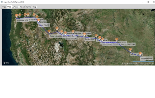
2. GTFP can generate over 500 interesting (built-in) flight plans.
3. GTFP can create waypoints from a search, such as your house address, latitude/longitude, POI (like "Eiffel Tower", "Grand Canyon"), or IOAC code.
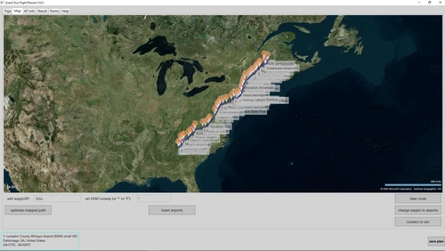
4. GTFP provides an easy way to navigate during VFR flight: It tracks the plane’s heading and the target’s bearing and distance together in a small window that can be overlaid on the main MSFS window. It allows you to slew to the next point in the route.
5. GTFP lets you overlay a small VFR map on top of MSFS where you can zoom in to great detail, or out to show as much of the world as you wish. It tracks your plane in real time. It has options to label political boundaries, show only roads, or show unlabeled geographic features (matching what you see from the cockpit).
A Users' Guide is available. Here is a quote from the FAQ that shows a way to use some of GTFP features.
-------
I want to fly over both my house and the Cleveland Museum of Rock and Roll. What do I do? Put your house address in the add waypoint box (on the Map page) and click enter key. When the waypoint is created, right click on it and then on “add nearest airport” button (or put a specific airport code in the add waypoint box). Set that airport to be both FIRST and LAST via right click on the airport map pin. Put “Cleveland Rock and Roll Museum" in the add waypoint box and click enter key. Now click on optimize mapped path button to make the shortest route. That should generate the flight plan you want.
------
User Reviews
Review data
Share your thoughts
If you’ve used this add-on, share your thoughts with other pilots.
Write a reviewThelynxPA Premium
This is a fantastic app. I started out cherry picking through the list and am now flying every plan presently on G. Visiting places I never would have imagined and seeing things that are truly amazing and this is just a game I keep telling myself. Thank you for putting this together and I look forward to updates with more wow factor flying.
occupancy.moist7
Hi,
I am having a problem with the generated waypoints when I open up the PLN file in MSFS. They are showing up as the north pole instead of the waypoint plotted in the GT tool. Any idea why?
fredm73 1 month(s) ago
Thanks for the bug report. I am unable to duplicate this problem. Could you email me what you did to create the flight plan that caused the problem and include the steps you did in GTFP so that I can try and duplicate it. My email address is in the User's Guide at the end.
On 2/28 I downloaded your GTFP- FP into MSFS. It seems to work now: the MSFS chart and navaid waypoint (distance and direction) all conform to GTFP's generation.
Please ensure you have the latest MSFS patches and try again. If the problem persists, let me know and I will look further. PS: I note that there was a similar complaint about LittleNavMap generated FP's, but have heard of no follow-up.
According to the original poster (3/1), this was a bug elsewhere and is now cleared up.
LarryFS2020
10.3 runs w/o any "special" setup. This is truly a Great Program! Use it all the time to setup NeoFly "stacked missions". Does not seem to be the case for 10.4 (no setup instructions). I seem to be missing something.
fredm73 4 month(s) ago
Could you be more specific? I did not change anything (that I know of) that would affect setup. If I can duplicate the problem I will seek a solution. If you wish, email me with as much detail as possible. My address is in the User's Guide, p.17, , in the Help tab.
LarryFS2020 4 month(s) ago
The problem was Mine. I was not running the latest version of windows .NET desktop runtime. For anyone reading this make sure you are running v6.0.10! Sorry for the misinformation about this Excellent s/w. I would have a much more difficult time planning "stacked missions" in NeoFly without! Thank Fred Mellender for a great product!
Hawker
Looks great. Can I use this stand-alone or does MSFS have to be running?
fredm73 6 month(s) ago
You can use GTFP alone, without MSFS running or even installed on your computer
cusance
A wonderful piece of Software. Elegant is also how I would describe it. So much software these days tends to be 'clumsily' executed.
I would however ask for one additional change: instead of only copying the Result to the clipboard, could you add a print option to the default printer. A screendump would do it in landscape. No additional info required. It would be an additional way of flying without importing the plan into MSFS but also avoiding all the faffing around needing to import the clipboard into Notepad or something. Purely flying on bearings from paper would also be fun.
Thank you.
fredm73 12 month(s) ago
Thanks for the suggestion and the compliment.
I will think about this improvement.
However, printing in .NET Core adds significant memory requirements to the downloaded application and about 150 lines of code to do it properly.
cusance 12 month(s) ago
I thought that might be the reason. I was hoping a middle way might be open to copy the Result to the NotePad and open it. Then all one had to do was click the print button or first add any additional comments.
But I totally get what you are saying. Modern languages and coding methods arent exactly careful with the space they use, not like the old days
😞
Enigmaau
Downloaded this a couple of weeks ago. Loving it. Makes flight planning nice and simple. Love the info it gives for your route. Thank you for such a great little program.
kklosterman
Hi Fred,
Haven't talked in a while.
Just downloaded the 10.2 version and I believe this issue is back. From discussion 6 months ago comment:
There is this bug in GTFP: the folder name was saved when you *saved* an FP, but not when you *loaded* an FP. I will change the logic to save the folder name you select on *both* events in the next version of GTFP. (Note that only one folder name is going to be saved by GTFP, and that MSFS does *not* save the folder name you load/save an FP to). The fix to GTFP will be out in a week or so.
I'm not sure if this is the problem you are seeing. If not, I need further information from you so as to duplicate your bug. Anyway, thanks for the bug report!
fredm73 1 year(s) ago
Thanks for the bug report. It should be fixed in the latest version, V10.3, now uploaded.
kklosterman 1 year(s) ago
As always thanks for the update and quick work. Stay safe!
Warrie
Hi 😊 I want to make a world tour. Saving a flight is not an option, when I reload a flight I can't change the weather or time of day anymore. What would be the best way to use a huge flightplan - Each time I start flying, delete the legs I did in my previous flight and save that plan? or would there be a more convenient way?
fredm73 1 year(s) ago
Your strategy is what I follow, except after I finish some legs and wish to quit, I use GTFP to delete the waypoints I have visited and save the FP. I load that into MSFS and GTFP the next time I fly.
I am currently visiting every country in the GTFP plan for that. I am also using the "half-slew" when things get boring.
CptMoustache
I may have missed it but is there a way to control-select more than one item in a list? ie more than one country?
fredm73 1 year(s) ago
That is not possible. Where you thinking this would be a way to combine multiple plans into one flight plan?
CptMoustache 1 year(s) ago
I was more thinking to combine countries. So I'd control-select, say, UK and France for a tour. Or select multiple US states. Things like that
fredm73 1 year(s) ago
I understand and will think about this feature.
In the meantime, I suggest you use the Map page. Turn on political boundaries (right click somewhere on the map). Then double click on/within the countries you wish to visit. That adds a waypoint. After you add a waypoint, click on "insert airports", which (while honoring the parms on the Parms page), will give you a straight line of airports from the previous waypoint to the one just added.
After you have a route through the countries you wish to visit, you can click on "change waypts to airports".
I think that will give you a flight plan close to what you seek. I suggest you play around with the map page's variety of ways to add waypoints, insert airports, etc, to see if you can, without too much trouble, make a satisfactory plan.
I welcome your suggestion.
Nounours06
I would like to insert waypoints, using GPS coordinates. How is it possible?
fredm73 1 year(s) ago
Just enter the (lat, lon) in the 'add waypoint" box on the Map page: e.g. (48.858, 2.294). Full information on this box is in the User's Guide, accessible from the 'help' tab.
Johnn18
Following on from my earlier comment I was downloading the wrong file, it all work brilliantly as usual. Shows it still works on windows 11.👍
Johnn18
Just downloaded and reinstalled this and every time I try to run the programme it says .net core is not installed with a link to install it. Have installed this three times but still no joy. Is this because I am running windows 11?
fredm73 1 year(s) ago
From the User's Guide:
---
You may get a notice to download .NET Desktop Runtime 3.1. Download it from https://dotnet.microsoft.com/download/dotnet/3.1. Be sure you download the Desktop Runtime.
---
fosheem 1 year(s) ago
I'm having the same problem, I just installed the version your program's link took me too and it doesn't work, even after a reboot (version 6.1 for desktop, 64-bit). The link you provided (above this comment) no longer works, Microsoft is no longer offering that version. What next? Thanks ahead of time!
fsnews24
Five stars!
You can find a short review here:
https://flightnews24.de/2021/10/15/gratis-flugplaner-fuer-touren-im-msfs/
Lif
Hi fredm 73,
Just downloaded Grand Tour Flight Planner as a result of spotting a piece in the 14th October Dev update in the MSFS 2020 forum.
The only omission of functionality I can see that precludes me trying it out is a lack of client and server modules that would allow me to run the program on my secondary laptop. Essential IMHO when in moving map mode.
Do you plan to implement this feature in a future version?
Whatever, love you freeware devs!
Many thanks.
fredm73 1 year(s) ago
Thanks for the suggestion. I will think about this, but have no plans at this time to implement it.
Frankly, I don't see an easy way to do it.
Can I assume the computers are on the same network? Can I assume you will open up some access/sharing permissions between files/ports on the two computers?
If I detect sufficient interest I will tackle the problem.
However, please note that much work can be done in GTFP before starting or connecting to MSFS. After connecting to MSFS, GTFP can be shrunk to one or two small windows that overlay MSFS window. These can disappear/pop-up as the mouse moves out and in one of these windows. Hence they can be unobtrusive until consulted.
Lif 1 year(s) ago
Hi fredm73,
And thanks for the reply.
I think the idea of using GTFP on a second machine is only really applicable if using the moving map component. And I take you at your word when you say it would be difficult. So please don't start such an undertaking on just my account will you. Besides, I use Little Navmap on a local network for my moving map. Have done for years, and I am unlikely to change now.
I will though be using GTFP when planning my next grand tour. It has some nice features that I can make good use of.
In appreciation of all your efforts.
Best regards.
bstikkel
Hello fredm73,
It happens often, when I create a flightplan in GTFP, save it in MSFS and start it in MSFS, the airplane starts in the air instead on the airport I designated as startingpoint. Can you tell me, if I do something wrong or that this is just a thing of Grand Tour Flight Planner or MSFS?
Thanks for clearing this up.
Bram
fredm73 2 year(s) ago
One possibility is that MSFS does not have the airport in its DB (GTFP uses OurAirports for its DB). You could test this: go to MSFS and put the ICAO code there (as the start) and see if MSFS knows it.
Another possibility: make sure GTFP knows an airport by putting in the ICAO code in the "add waypoint" box (not text, like "O'Hare Airport"). Otherwise, GTFP puts you at a waypoint (not at an airport) and MSFS will start you in the air. If you do not know the ICAO code, you can use text, and then the change waypts to airports button. If you still have difficulties, please email me the .PLN file (my email address is found in the GTFP User's Guide, which you can read via the 'help' tab).
bstikkel 2 year(s) ago
Thanks, I will try these advises
kklosterman
V8.3. I thought I saw the answer to this question brought up, but can't find it if you can update me. Program used to keep the load and save folder .pln and when saving it would allow me to use the same folder the msfs loaded or saved to. How can I get this sync'd up so as not to have to jump between folders? Again love this program and rely on it for flights 😊
fredm73 2 year(s) ago
There is this bug in GTFP: the folder name was saved when you *saved* an FP, but not when you *loaded* an FP. I will change the logic to save the folder name you select on *both* events in the next version of GTFP. (Note that only one folder name is going to be saved by GTFP, and that MSFS does *not* save the folder name you load/save an FP to). The fix to GTFP will be out in a week or so.
I'm not sure if this is the problem you are seeing. If not, I need further information from you so as to duplicate your bug. Anyway, thanks for the bug report!
The next version of GTFP will let you select a runway, let MSFS select it for you, or ask MSFS to select a parking space instead. The latter allows you to practice taxing and talking to ATC-ground before you take off.
I am interested in what new features in GTFP would be useful. Email me (the address is in the User's Guide) if you have ideas.
kklosterman 2 year(s) ago
As always your da man ! Thanks again for the quick 9.1 and 9.2 update 😊
MrMo
Nice work, thanks! 😉
ihhgvdd
unusable without dark mode , can you please add or tell me how to edit it to do so ? just want black instead of white
fredm73 2 year(s) ago
I changed the appearance in V8.3: backgrounds are now light gray instead of white. It is difficult to make a "dark mode" with black backgrounds. However, as a workaround, you can use Windows 10 "high contrast". (Settings/High contrast). There you can set colors to whatever you wish and make your own "dark mode", which is honored by GTFP.
ihhgvdd 2 year(s) ago
😊 , very good otherwise.
fsim3 1 year(s) ago
Hi Fred, just discovered your Map tool today, after reading MSFS annoucement here : https://www.flightsimulator.com/october-14th-2021-development-update/
A small idea for Bing Maps dark mode (+1) https://www.bing.com/api/maps/sdk/mapcontrol/isdk/canvasdarkmaptype
Thanks having build this Map Tool and sharing to the community
Regards
fredm73 1 year(s) ago
Thanks for the tip. I believe this is for the webpage interface to Bing, not the desktop/C#. However, I will look further.
Scooty
V7.6, this thing is getting nidcer and nicer. 😊
A tiny suggestion: maybe set all numbers with a "separator" for "thousands".
Like
100.000 or 5.000
instead of
100000 or 5000
for perfect readability.
Now i really have to think very hard, to maybe think of any more details to add.
It´s really one of my favorite flight planning tools!
Thanks again for this!
😍
Scooty
V7.4, did i mention, that i love this tool?
😉
Yes, the selectable Aitport sizes work perfectly, as intended.
Thanks a lot!
I´m still discoverind features, i had not noticed before.
(1) It´s great to be able to set VFR waypoints. Could the "pins" get a different color than "normal" waypoints, for better visual interpretation? Like start/end in red, all calculated waypoints in orange (= as it is now), VFR waypoints in blue? Colors should have a good contrast to each other and not be too light, so we can see it on a zoomed out worldmap easily.
(2) Question: what is the difference between a waypoint, when i just doubleklick on the map or if i also set it as "VFR waypoint"? Are they handled in a different way for route calculation or anything?
(3) Deleting routes: could we change this from a preferences setting to different buttons on the "map" screen, so we can directly delete in the desired configuration?
Like, 1 seperate button for the following:
Having one seperate button to klick would make it a tiny bit more comfortable to use, i think.
(4) Layout of the "Result" page: could we move the columns for bearing and distance more to the right side, so we get more space for destination? Destinatio ncan get cut off easily, so we can´t see the size of some airports anymore.
(5) We can see the "longest leg" displayed. How about also showing the shortest leg and also the average leg lenght?
(6) distance would be enough to see in ###,0 instead of ###,000 to maybe save a bit space.
(7) could we also get the "cumulated" traveldistance for each leg, to see how far we travelled in total per leg? like, when having a distance of 100 between each waypoint, it would show 100 till WP2, 200 till WP2, 300 till WP3...
(8) and now about something, i am thinking about for a couple of days: I would like to create one large flightplan for an "mixed" trip.
I start in Europe with large legs like 700 nm, large airports, to travel quickly away from home. I wanna go to maybe Central Africa. From there, i wanna go on with legs of maybe 250 nm, small airports only, travelling in many hops to South Africa. From there, i wanna travel back home quickly in large legs, 700nm, large airports only.
It maybe could work like this:
start from Europe to Central Africa "just as we have it right now".
When this is calculated, it would need to "freeze" the route, it´s end point shall be the start point for the next calculation, i setup the different options and calculate this second part. I should be able to edit or do what ever is needed for this "second calculation", as usual. When done, we "freeze "the overall route, which is the first frozen part + the new part" ... now the last WP of this overall route shall be the startpoint for the folliwing calculation... and so on.
In other words: lets create a route, maybe modify it... then "save" this result and lets continue with the next part of the route in another configuration... then "save" this results again and go on with the next part of the trip in another possible configuration...
This should result in one large flightplan.
Why this? Because it´s fantastic to document a large trip in one piece, not having to handle several different flightplans. This may seem a bit "specific", but there are nice new possibilities, when we could also create plans that way, in some "modular" configurations.
fredm73 2 year(s) ago
1,2. The "set as VFR target" option on a waypoint has been removed. This function was superseded by the GTFP VFR window (see p. 5 of the User's Guide). The purpose was to show the distance/bearing of the waypoint relative to the plane's position. The VFR window does that and lets you change the VFR target to any waypt in the route.
3. I will look at this, but I feel the Map Page is already very cluttered.
4. I changed the layout of the Result Page.
5. I changed the result page to show the shortest leg. I will think about adding the length of the average leg. I'm not sure this would be very useful.
6. I changed the precision of the distance numbers.
7. I changed the result page to show cumulative distance at each waypoint.
8. At this time you will have to do this manually, thus:
A. set FIRST, LAST for the "Europe Trip". Set airport size. Find Airport Hops.
B. set FIRST, LAST for "Central Africa". Set new airport size. Find Airport Hops.
C. continue with other trips
D. reset FIRST, LAST to the first airport in the trip (in Europe), LAST to the last
one (in Africa, or wherever).
E. Optimize route if necessary.
I think this will do what you wish. As you "add trips", no route is ever deleted. The
purpose of the FIRST/LAST resetting for each "subtrip" is to find airports of the
correct size for that part of the trip.
GTFP always worked this way (see the User's Guide), in that you can reset FIRST/LAST only because you want to insert airports between waypoint in the middle of a route. Just be careful not to "optimize mapped path" unless the FIRST/LAST are set to their true values.
Try Version 7.5 when it is available (later today).
Scooty 2 year(s) ago
Wow, you´re faster with implementing changes than i am with typing...
😉
Great work again, thanks a lot!
I did a testroute, as you suggested, 45 hops and 24.000 nm in total, starting with longs legs, short ones in the middle, very long ones back home. Yes ,it works as you mentioned, thanks for the hint!
Once more back to the "Results" page:
(1) can we please format all distances + cum into the format
###.###,#
to get a separator "." for thousands?
(2) can we please align bearing , distance and cum at the right side, not at the left side? Or, if possible, simply align each value at the "," to get the mall "in a row", to increase readability.
Would be great, if the cum values also get aligned at the right side or at the "comma". That way ,both columns (distance, cum) would be better readable.
(3) do we really need bearing with values of ",###" displayed or could it be just ",#" maybe?
(4) maybe also format "Total distance" on top of the window and "Done length" at the bottom of the window into ###.###,# to have it in a "uniform" style.
(5) shouldn´t there maybe be a "scroll bar" to scroll left or right, if the results window is dragged too narrow or if you use a very small screen?
(6) left of the "copy to clipboard" button there is a lot of empty space.
Could you move this button down, to the same area where "save plan" is? That way, there would be more space used to display the route data.
(7) There are some Airports with exremely long names, like SCEL or CYWG.
I would NOT make it´s fields broader , as it will make it harder to read in total. The values of bearing and distance are getting a too big space.
Could you create columns to be made wider or narrower by the user, just like in Excel? To drag them broader, if we really need it and to keep it more compact, if we only have relatively short names displayed.
This post is getting too long... i can´t read it on my screen anymore...
😉
fredm73 2 year(s) ago
1,3,4. I fixed the numeric formats.
2. I made the Result report a bit clear wrt alignment (although not at decimal point).
5. Horizontal scroll bar added as necessary.
6. copy to clipboard button cannot be moved to area of save plan button.
the latter is at the bottom of all windows, the former is local to Results window.
7. User setting of column size in Results window is too big of a change. I shortened
long AP descriptions in a natural way. CYWG and SCEL are no longer a problem.
I suggest starting a *new* comment as this one is too long.
Try version 7.6 available later today.