Description
Note: This scenery now uses flag and windsock scenery objects from trfsto's "Windy Things" scenery library available for download at flightsim.to at the following URL:
https://flightsim.to/file/14024/windy-things
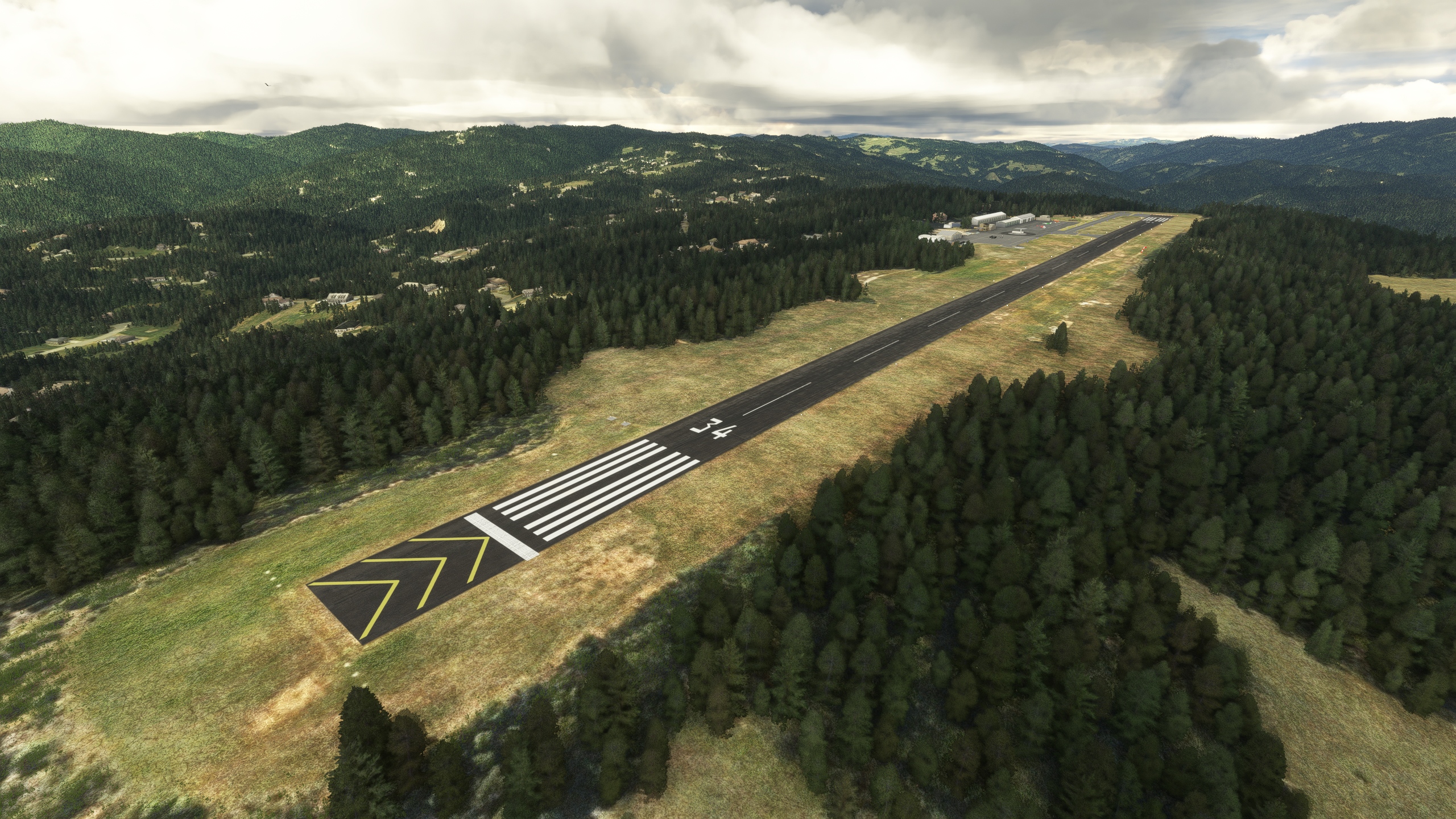
Located in Mendocino County just northwest of Willits CA on a small mountain with an elevation of 2,063 feet, this is where a young 14-year-old Stoopy received his first few crucial hours of instruction in a Cessna 152, N6266T. The single 2,995-foot asphalt runway overlooks the valley, thus providing visually enticing arrivals and departures. Currently, this airport is also home to one of the many CalFire Helitack bases in the area, which this scenery aims to duplicate with a functional helipad, available as "Helipad 01" in the MSFS start menu (Scroll to the bottom of the list of parking areas when starting a flight).
There are basic amenities including AvGas, a pilot lounge and Cessna-sponsored flight training. This airport enhancement includes custom 3D objects created in Blender to help re-create the unique atmosphere of this airfield.
Enjoy!
-Stoopy
028 Willits Municipal Airport - Ells Field
Located in Mendocino County just northwest of Willits CA on a small mountain with an elevation of 2,063 feet, there are basic amenities including AvGas, a pilot lounge and Cessna-sponsored flight training. This airport enhancement includes custom 3D objects to help re-create the unique atmosphere of this airfield. Note: This scenery now uses flag and windsock scenery objects from trfsto's "Windy Things" scenery library available for download at flightsim.to at the following URL: https://flightsim.to/file/14024/windy-things


User Reviews
4 reviews
Location
More Information
Version History
- Corrected packaging error with version 1.02 that caused installation issues for folks updating from version 1.0.1, and the new Windy Things objects not to appear. My apologies and greatest thanks to flightsim.to users pmrose and EdTruthan. - Replaced Asobo version of the U.S. Flag and flagpole outside the airport gate, which actually was not a "stock" scenery object and was only visible for users who purchased the Reno Racing addon. The scenery now uses the U.S. and California flags and flagpole from trfstyo's excellent "Windy Things" scenery library, available for download as described above - Modified the airport beacon to use the Asobo beacon light simobject attached to an oversize light pole. The beacon should be much more visible now although there is no way to adjust the height of the beacon, hence why the light pole is scaled up
Related
Garberville Airport O16
This package provides buildings and other enhancements for Garberville Airport, ICAO O16, a public airport located 2 miles southwest of Garberville, a town in Humboldt County, California, USA. The airport covers 44 acres and has one runway. Airport weather is available, as well as fuel. This package uses all native Asobo scenery objects for low impact to frame rates. This is my first scenery project, thanks to all the dedicated YouTubers and folks on the forums who helped ease the learning curve!
by Stoopy
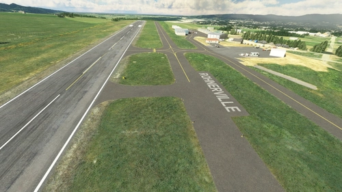
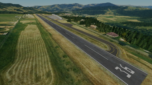
KFOT Rohnerville, Fortuna CA
Enhanced Scenery for KFOT Rohnerville airport, Fortuna CA - Located on a pristine emerald plateau overlooking the final few bends of the Eel River near the beautiful coastline of Humbolt County California, this scenery enhancement converts the default MSFS version of a desolate, featureless airstrip into the more fully-featured General Aviation haven that it's known for, with dramatic approaches and departures, ample parking, low nightly tie-down rates, correct VASI implementation on the primary RWY11, seductive night lighting, correct (if somewhat claustrophobic) Small GA parking in the lower west hangar area, a couple of groovy custom ground tectures and a more-or-less plausible rendition of the Cal Fire Attack Base located on the east end of the airfield.
by Stoopy
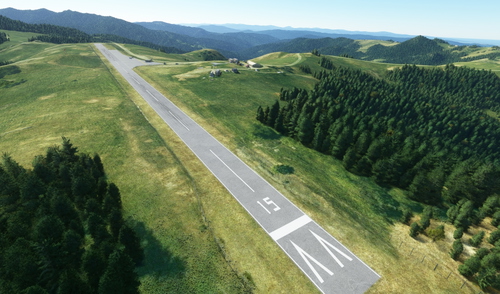
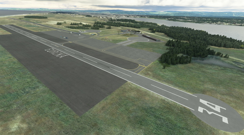
O19 Kneeland airport, Eureka CA
Kneeland Airport, ICAO O19, is located 10 miles southeast of Eureka CA on a mountain ridge with an elevation of 2,741 feet. The single 2,250-foot asphalt runway on top of sharply descending terrain makes for visually breathtaking arrivals and departures, and serves as a convenient alternate airport when nearby airfields at lower elevations may be closed due to fog or low-lying weather. It's also home to the CalFire Kneeland Helitack base, which this scenery aims to duplicate with a functional helipad, available as "Helipad 01" in the MSFS start menu (Scroll to the bottom of the list of parking areas when starting a flight).
by Stoopy
O33 Eureka / Samoa Field (and Drag Strip!)
Enhanced Scenery for O33 Eureka / Samoa Field (and Drag Strip!), Eureka, CA. Samoa Field is a lightly-used GA airfield with an interesting history and tons of PNW "cool factor" appeal. Bracketed by KFOT Rohnerville to the south and KEKA Murray field as well as KACV Arcata-Humboldt County airport to the north, O33 is built upon what was once a WWII Navy Blimp base. It's also home to the NHRA-sanctioned Samoa Drag Strip, a full quarter-mile dragstrip and haven for NorCal hot rodders and drag racers.
by Stoopy
Comments(25)
Log in to join the discussion
Log Inabout 2 years ago
over 2 years ago
https://www.youtube.com/watch?v=4pJiu6Qk9_U&t
over 2 years ago
over 2 years ago
over 2 years ago
over 3 years ago
Good Morning! Thank you for your hard work! A little problem in this update, it needs admin rights to place in community folder...I look forward to your update to this update,
Thank you!
over 3 years ago
Hmmmm that is indeed very odd. I didn't do anything different with this update, and those permissions are typically determined by your own system Were you able to install the previous version(s) without this issue?
over 3 years ago
In other words, if the folder you are trying to copy this into is set as admin write permissions only, or if the existing files are set that way, you'll be prompted to provide admin permissions. The files in the download shouldn't have any ownership assigned. Have you run MSFS as Admin recently or installed other similar packages like this recently without being prompted for admin access?
over 3 years ago
yes, as with all other sceneries…I know this does seem odd….
over 3 years ago
Thinking through this, if it was caused by the contents of this package, then it likely is already set to read-only or other perms in the folder that is already on your system. Could you please try deleting the existing folder "stoopy-airport-o28-willits" and then see if you can copy the new version into your scenery or community folder?
over 3 years ago
I did that but I am still experiencing the same challenge. I did notice that the new file I have to unzip twice conpared to the normal one unzip. Meaning after unzipping the actual download, I have to unzip the file within the zip.....I hope I was able to comunicate that properly...I have never experienced this before in the hundreds of other downloads......Go figure...:)
over 3 years ago
Well Sir, you are absolutely 100% right, I goofed pretty badly with the ZIP file for the 1.0.2 update, and inadvertently ZIPped up the 1.0.1 ZIP file instead of the folder with 1.0.2 in it. I apologize very much for the inconvenience and am very grateful for you politely bringing it to my attention and persevering through my hardheaded replies. Version 1.0.3 has just been uploaded and I was much more careful to confirm it was packaged correctly.
Thank you again and please feel free to suggest an airport of your choice that I'll try to put it in the queue for this series (as long as it's in California) :)
over 3 years ago
Everything processed as expected! Scenery looks fantastic!! Great Job!! Thank you!
If you need an idea for a future airport project, I would like to suggest General Fox in Lancaster..Thank you!
over 3 years ago
Very cool airport! I have a couple others in So Cal I'd like to do, so it's on the list now!