Description
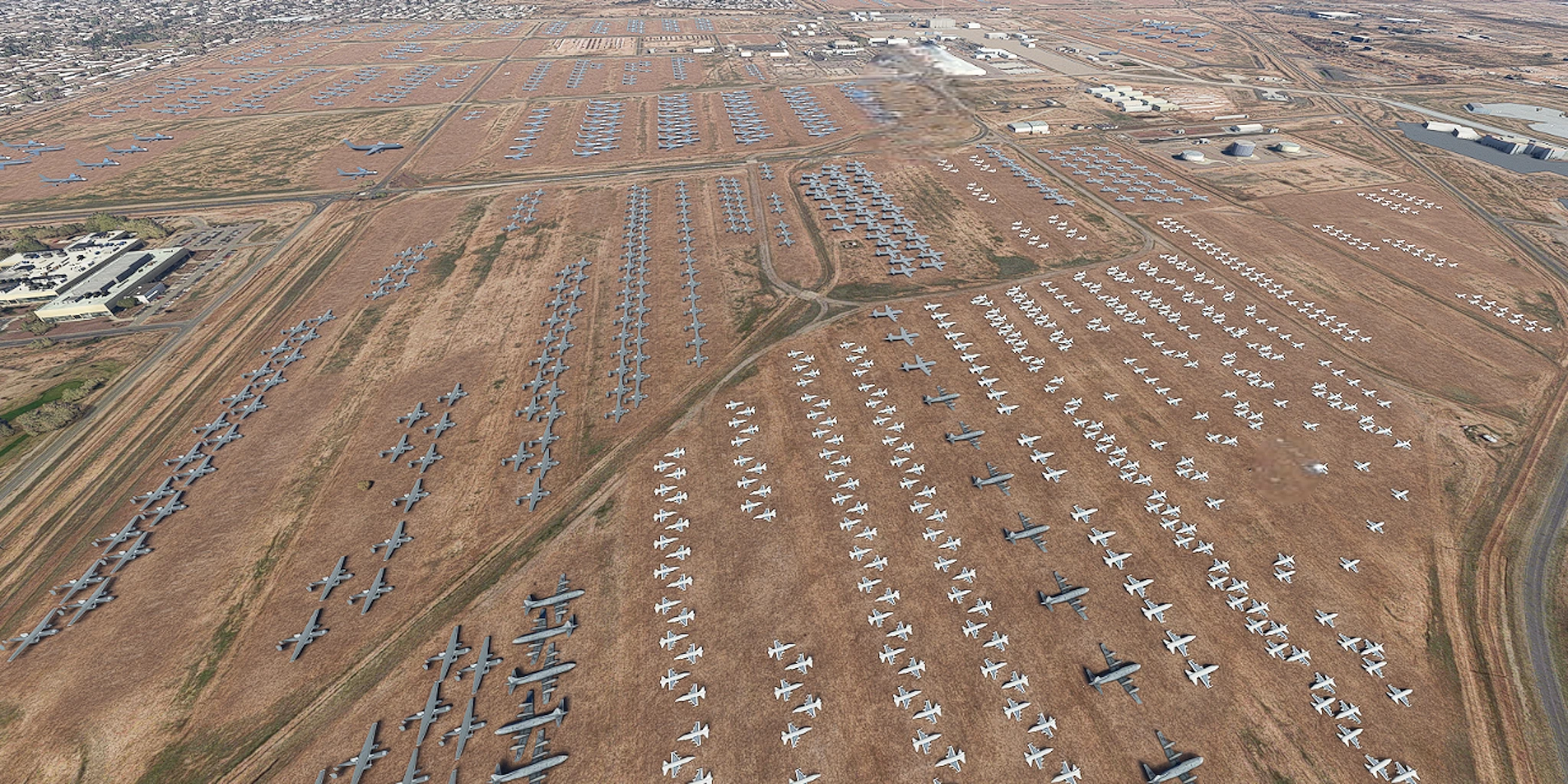
This is a flight plan for a low, slow sightseeing trip over the U.S. Air Force aircraft boneyard in Tucson, Arizona.
The 309th Aerospace Maintenance and Regeneration Group, often called The Boneyard, is a U.S. Air Force storage and maintenance facility. It is the largest aircraft storage facility in the world, with nearly 4,000 aircraft.
Recommended: World Update II: USA and World Update X: USA
This flight plan requires no navigation or GPS instruments. Simply follow the on-screen markers.
Note: When you are about to land at the destination runway, an MSFS directional marker tends to pop up, pointing in another direction. Ignore the marker and complete your landing.
25 March 2026: Updated this flight plan with a new route.
_____________________________________________________________________________
Departure runway: 04
Distance: 17 miles
Cruising speed: Less than 80 knots
Altitude: Below 500 AGL (Above Ground Level)
_____________________________________________________________________________
Do not use ATC, the copilot or autopilot. The moment they are engaged, they will alter or suppress the flight plan's waypoints.
MSFS waypoints are not designed for low, slow flights. See the included readme.pdf file for settings that are required for this plan to function properly.
This plan assumes that you have installed the world/city update(s) for this area.
Go to https://flightsim.to/profile/FederFlyer for hundreds of ultralight sightseeing flight plans.
Ultralight Sightseeing - Arizona - Tucson - Air Force Boneyard
This is a flight plan for a low, slow sightseeing trip over the U.S. Air Force aircraft boneyard in Tucson, Arizona. The Boneyard is the largest aircraft storage facility in the world, with nearly 4,000 aircraft.

More Information
Version History
Added link to optional scenery addon.
Related
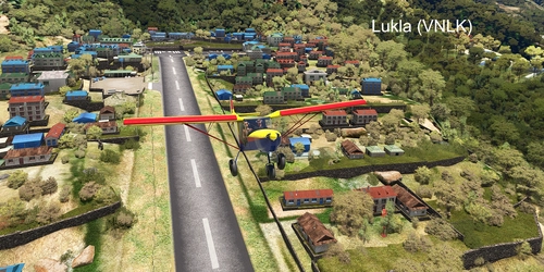
Ultralight Flight - Nepal - Lukla - STOL Landing
Tenzing-Hillary Airport (Lukla VNLK) was rated the most dangerous airport in the world for more than 20 years. It is considered the starting point for treks to Mount Everest. Although this is a high-altitude route for ultralights, it is mostly a descent of 2,400 feet and should not be difficult. This flight plan requires no navigation or GPS instruments. Simply follow the on-screen markers.
by FederFlyer
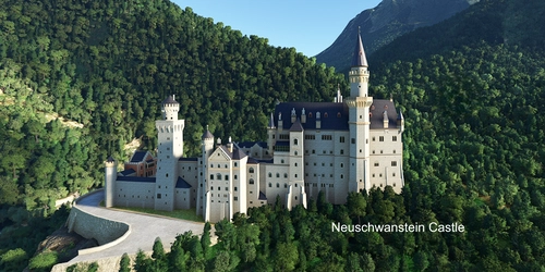
Ultralight Sightseeing - Germany – Neuschwanstein, Hohenschwangau and Ehrenberg Castles
This is a flight plan for a low, slow sightseeing trip to Neuschwanstein Castle, Hohenschwangau Castle and Ehrenberg Castle in Germany. This flight plan requires no navigation or GPS instruments. Simply follow the on-screen markers.
by FederFlyer
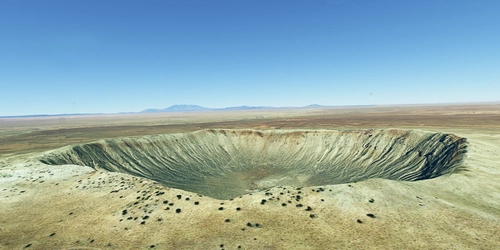
Ultralight Sightseeing - Arizona - Barringer Meteor Crater
This is a flight plan for a short, low and slow flight over Barringer Crater in Arizona. The crater was created about 50,000 years ago, during the Pleistocene epoch, and is cited as being the best example of a meteorite impact. It is about a mile wide and over 500 feet deep. It is named for the family-owned company that owns the land.
by FederFlyer
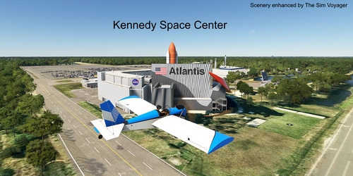
Ultralight Flight – Florida – NASA - Kennedy Space Center – Cape Canaveral
This is a flight plan for a low, slow trip over the Kennedy Space Center (Cape Canaveral). The space center is on Merritt Island, Florida. Since 1968, it has been NASA's primary launch center for spaceflights, including the Apollo missions, Skylab and the Space Shuttle program. This plan includes Launch Pad 39B, where Artemis II launched the first manned flight to the moon in 50 years, on April 1, 2026.
by FederFlyer
Comments(3)
Log in to join the discussion
Log Inover 3 years ago
I'm afraid that picture you posted of "Ryan Field" is actually the "Tucson Trap & Skeet Club". So landing there is definitely not recommended. You might get hit by skeet or shot at.
Ryan Field (a former USAAF airbase) is a few miles farther West and actually has three large paved runways.
over 3 years ago
I appreciate the heads up about the error. I flew the route and I saw what happened. When I approach Ryan Field, the skeet facility is directly in front of the Ryan runway. The Ryan label briefly appears directly above the vertical POI line for the abandoned skeet runway, giving the illusion that the skeet facility is Ryan.
I have updated the package with corrected info and a new Ryan image.
Thanks!
over 3 years ago
my pleasure :)