Description
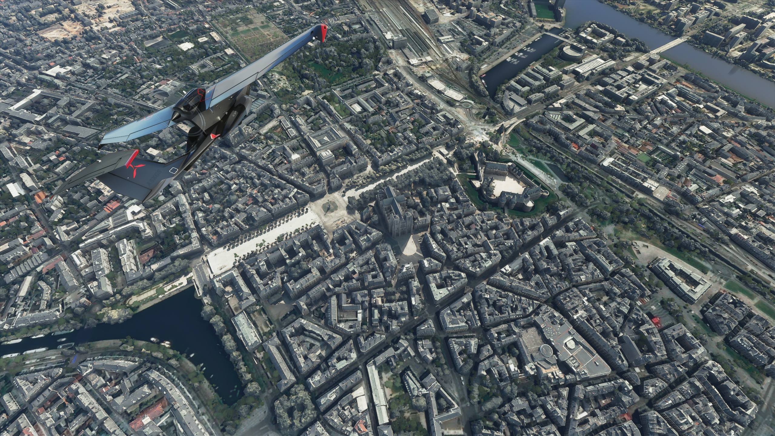
Nantes is a city in Loire-Atlantique on the Loire, 50 km (31 mi) from the Atlantic coast. The city is the sixth-largest in France, with a population of 303,382 in Nantes and a metropolitan area of nearly 950,000 inhabitants. With Saint-Nazaire, a seaport on the Loire estuary, Nantes forms one of the main north-western French metropolitan agglomerations.
It is the administrative seat of the Loire-Atlantique department and the Pays de la Loire région, one of 18 regions of France. Nantes belongs historically and culturally to Brittany, a former duchy and province, and its omission from the modern administrative region of Brittany is controversial.
Nantes was identified during classical antiquity as a port on the Loire. It was the seat of a bishopric at the end of the Roman era before it was conquered by the Bretons in 851. Although Nantes was the primary residence of the 15th-century dukes of Brittany, Rennes became the provincial capital after the 1532 union of Brittany and France. During the 17th century, after the establishment of the French colonial empire, Nantes gradually became the largest port in France and was responsible for nearly half of the 18th-century French Atlantic slave trade. The French Revolution resulted in an economic decline, but Nantes developed robust industries after 1850 (chiefly in shipbuilding and food processing). Deindustrialisation in the second half of the 20th century spurred the city to adopt a service economy.
In 2020, the Globalization and World Cities Research Network ranked Nantes as a Gamma world city. It is the fourth-highest-ranking city in France, after Paris, Lyon and Marseille. The Gamma category includes cities such as Algiers, Orlando, Porto, Turin and Leipzig. Nantes has been praised for its quality of life, and it received the European Green Capital Award in 2013. The European Commission noted the city's efforts to reduce air pollution and CO2 emissions, its high-quality and well-managed public transport system and its biodiversity, with 3,366 hectares (8,320 acres) of green space and several protected Natura 2000 areas.
GPS: 47° 13′ 5.16″ N, 1° 33′ 10.08″ W
Credits:
This scenery has been extracted from Google Maps, hence all 3D credits goes to Google.
This scenery has been generated with the Google Earth Decoder tool (credits to /u/Jonahex111):
https://www.reddit.com/r/FS2020Creation/comments/j3faaj/google_earth_decoder_now_userfriendly/
Addon history:
v1.0: initial release
v2.0: overall optimization:
This is a major update that optimizes the package, as it drastically reduces the number of texture files:
- less files on the package:
before: 21419 files
after: 1659 files
- reduced CPU footprint
- reduced loading time at startup
- less CPU load, so it can leads to better perfs depending on the config
- better road traffic integration
v3.0:
- Fix some texture flickering issues
- Fix a big issue with the LOD management system, due to the way Google Earth Decoder places and sizes the tiles. Now, there should not be any FPS issues, and framerate should be better and more consistent
v3.1: change LOD settings
v3.2: Fix flickering issues
v3.3: Add a fix for possible CTD issues ( https://flightsim.to/blog/creators-guide-fix-ctd-issues-on-your-scenery )
v3.4: Change LODs settings
v3.5: reduced package size
v3.6: remove Stade de la Beaujoire for WU4 world update compatibility
v3.7: fix railway bridge
Installation:
Remove old nantes and beaujoire or thalixte-beaujoire folders, if they exist. Download thalixte-nantes.zip. Extract thalixte-nantes folder into the Community folder.
If you want to donate, you will always be welcome to help me continue with more projects and update the existing ones https://paypal.me/Thalixte.
Nantes City
Discover the vibrant city of Nantes with this detailed add-on, featuring the sixth-largest city in France with a rich historical and cultural background. Explore the citys landmarks, industries, and urban environment with this immersive scenery package. Experience Nantes quality of life, recognized by the Globalization and World Cities Research Network, and its commitment to sustainability and green initiatives.Immerse yourself in the beauty of Nantes, from its historic origins to its modern urban landscape, and enjoy a unique flight experience over this picturesque French city.

Supporters

User Reviews
25 reviews
Location
More Information
Version History
Fix railway bridge
Related
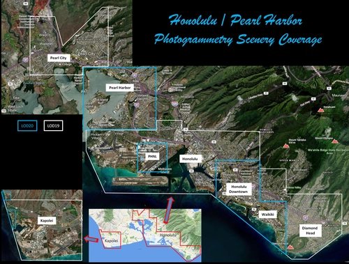
Honolulu
Explore the photogrammetry scenery of Honolulu, including the iconic Pearl Harbor area with optimized performance for better FPS. Discover Waikiki, Honolulu downtown, and more with this detailed addon. Enhance your experience by adding free mods for carriers, battleships, and military airplanes in Pearl Harbor and surrounding bases. Support the creator for future updates if you enjoy this mod.
by steveli
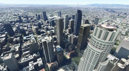
Downtown Los Angeles
Various buildings and monuments that are missing from Los Angeles in the game that shoudn't be. Wilshire Grand Center, SoFi Stadium, 801 S Grand, 825 S Hill, 888 S Hope, 1000 Grand, Apex the One, Atelier, Aven Apartments, Metropolis Towers, Level Los Angeles
by senecadriver
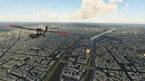
Paris
Explore the iconic cityscape of Paris in Microsoft Flight Simulator. This detailed add-on captures the essence of the French capital, featuring famous landmarks and architectural marvels. With accurate GPS coordinates, immerse yourself in the beauty of Paris, known for its historical significance and vibrant culture. Download now and experience the City of Light from a whole new perspective.
by Thalixte
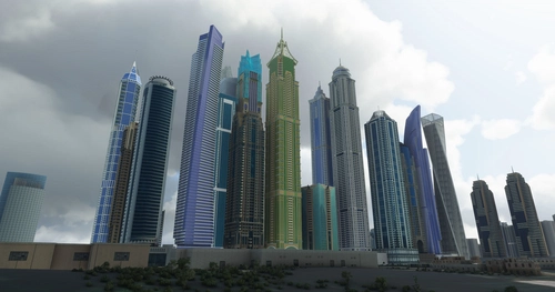
Dubai City Pack
Explore a detailed rendition of Dubai City and Jebbel Ali Port featuring over 250 custom buildings and various landmarks like the iconic hotels and tourist attractions. While focusing on enhancing the daytime visuals, this pack offers improved textures for select buildings, promising a refreshing experience for simmers. Additionally, adjustments have been made to SkyDive Dubai Airport to address previous elevation issues, ensuring a more immersive flight into this dynamic cityscape.
by risuali
Comments(52)
Log in to join the discussion
Log Inalmost 3 years ago
over 3 years ago
This is just incredible, i'm living here and it's a pleasure to see my city as close as the reality. Can't wait for a V2 ! thanks for that !
over 3 years ago
Super travail comme toujours! :)
over 4 years ago
Thanks for this great scenery, works flawlessly with SU7
over 4 years ago
Limoges, pleeease, you're work is incredible and my donation for Limoges will be good!!!
over 4 years ago
Oui le pb des arbres est vraiment gênant. Ci dessous 2 liens vers des instantanés:
http://www.pilote-virtuel.com/img/members/6381/thalixte-Nantes---pb-arbres-1.png
http://www.pilote-virtuel.com/img/members/6381/thalixte-Nantes---pb-arbres-2.png
Si ca pouvait être corrigé ce serait très bien.
La scène MSFS par défaut n'a pas ce souci.
almost 5 years ago
C'est vraiment magnifique, merci beaucoup pour ce boulot !!!
En revanche, les arbres du model photogrammétrie sont "gris", on dirais parfois des roches, est-ce que tu as prévu de repasser dessus un jour ? :)
Merci encore pour ce travail de dingue !
about 5 years ago
Thanks for the City of Nantes! This performs better than photogrammetry that needs to load over the internet! Spent many years traveling back and forth between Rennes and Nantes. Would there be a way to exclude photogrammetry trees? I notice a lot of MSFS generated trees inside the photogrammetry ones. The MSFS trees would look better and the scene might be even more optimized if the photogrammetry trees were not present.
Cheers, and thanks again! :)
about 5 years ago
superbe travail , suis je le seul à avoir un soucis avec le pont de cheviré , il y en a comme 2 , un bien fait et en parallèle en dessous un tout moche et plat où roule des voitures
about 5 years ago
Non, je ne pense pas que tu sois le seul. J'ai fait des progrès depuis cette scène. Il faudra que je la refasse en mieux quand j'aurais deux minutes
almost 5 years ago
Bonjour,
Est ce que ce serait possible de rendre le pont de Cheviré optionnel si vous refaites une nouvelle mouture pour Nantes?
Sur la scène de LFRS chez Jetstream design le pont de Cheviré est déjà modélisé, ce qui rend incompatible l'aéroport payware avec toutes les scènes freewares de Nantes existantes ( enfin, en tout cas, on a le pont de Cheviré en double, ce qui est assez moche à l'approche )...c'est vraiment dommage...
about 5 years ago
about 5 years ago
about 5 years ago
about 5 years ago
about 5 years ago
about 5 years ago
about 5 years ago
As someone who has tried (and failed!) over and over to follow the instructions for doing a city from Google (obviously I am doing something wrong - all seems fine until I go to import it into MSFS when I just get lots of 'Unknowns' and it all fails!), could you possibly look at doing Milton Keynes and Luton northern airport approach. Please Please Please.
I will keep trying, but failing so often is quite disheartening! :(
about 5 years ago
J'ai de la famille a Nantes et c'est un vrai plaisir de survoler la ville et de retrouver les coins familiers, petit bémol pour le Maillé Brézé qui est coulé dans la Loire dans l'état actuel de la photogrammétrie... :/
Cela reste tout de même un travail fabuleux comme à chaque fois, de très bonnes perfs, au dessus de 45 fps.
Merci pour ton travail!
Great addition , great perfs, above 45fps with RX 5600 XT and R5 3600.