
It is with great sadness I present to you the last leg of the "Get Your Kicks Above Route 66" series, or maybe it should be with great joy..oh well, you can decide for yourselves which it should be.
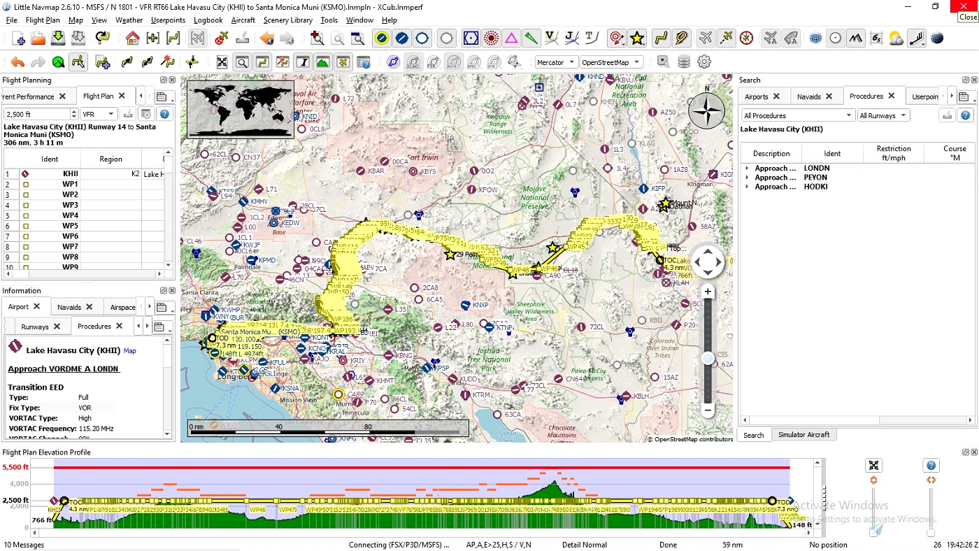
California, the Golden State has a vast and varied landscape from deserts to forests and everything in between. It's also is the terminus for what many consider to be the most famous highway in the U.S. if not the world, Route 66. We'll start where we last landed at Lake Havasu City (KHII) in Arizona and make our way northwest across the Colorado River and into California where we will catch a look at the Havasu National Wildlife Refuge before heading west again into the desert, it'll be awhile before we see another body of water of any size so you might want to bring along your favorite beverage on this flight. Just to the north of WPT28 is the Dead Mountains Wideness Area.
You'll fly past and over many mountain ranges and wilderness areas along this journey. I'll point out a few along the way. at WPT34 we'll fly over the Mojave National Preserve & Monument. From here fly southward and between WPT's 45-46 just to the north is Clipper Mountain Wilderness Area and then the Trilobite Wilderness Area in that order. You can land and dig for Trilobites in the Wilderness area if you wish, but only in designated areas. To the south of WPT48 is Bristol Lake. Also from about here all the way to WPT73 is Twentynine Palms and home to the Marine Corps Air Ground Combat Center and Marine Air Ground Task Force Training Command. whew..try saying that three times fast! I recommend staying with the flight plan through here, but that's up to you, fly at your own risk!
To the south of WPT's 75-86 are the Rodman Mountains & Newberry Mountains Wilderness Areas. At WPT's 88-89 we'll fly over the Marine Corps Logistics Base Barstow before heading into the city of Barstow proper. While in Barstow the railyard that stretches just north of WPT's 95 & 96 is the BNSF Bristow Railyard. As usual I'll provide a few links below to some of these sights. I'm sure you've noticed that on this leg of the journey, like the others, the route often follows along railroads and rivers and at WPT127 you'll cross over the Mojave River from here all the way to WPT151 we'll fly over the most populated area so far Hesperia then into the San Bernardino National Forest. Fly through and enjoy this rugged mountainous region all the way to WPT184. From here on till we end our journey, will mostly be over sprawling urban areas with the mountains and forests to the north.
At WPT193 is another of the famous Wigwam Motels that have been brought back to life for tourist to enjoy. From here on I'll mostly leave points of interest to you to figure out. With a few exceptions.
At WPT203 there appears to be several mining areas just before crossing over the San Gabriel River. Just straight west of WPT210 is the Santa Monica Race Park, not for cars but for horses, we'll fly around to the north of the park and the LA County Arboretum as well. Keep heading west until making a turn south at WPT214 in Pasadena then head southwest again at WPT215. Cross over the Los Angeles River at WPT231 and Dodger Stadium will be directly to the west in front of you, we'll pass it a couple times, you'll see why in a moment.
Chinatown is at WPT235 and Los Angeles Union Station is just to the east of WPT236. Keep flying and at WPT238 at the intersection of South Broadway & West 7th Street you have reached what was the original 1926 terminus of Route 66.
Our flight isn't over yet, I said we would go past Dodger Stadium again and here's why, can you guess? Yep another realignment made in the late 1930's early 40's. Yippee! From here you'll do a bit of a backtrack north to WPT's 239-242 and Dodger Stadium will be just east. South of WPT243 is Echo Park & Lake. We still have a ways to go and more sights to see from here, like our next one south of WPT257, Hollywood Forever & Hollywood Funeral Home, the resting place of several famous Hollywood actors and others in the film industry. Speaking of Hollywood we might as well go a little ways off course and see the Hollywood sign it's only a few miles north of here at WPT258 on the way back to Route 66 fly over Hollywood Reservoir & Mulholland Dam WPT259.
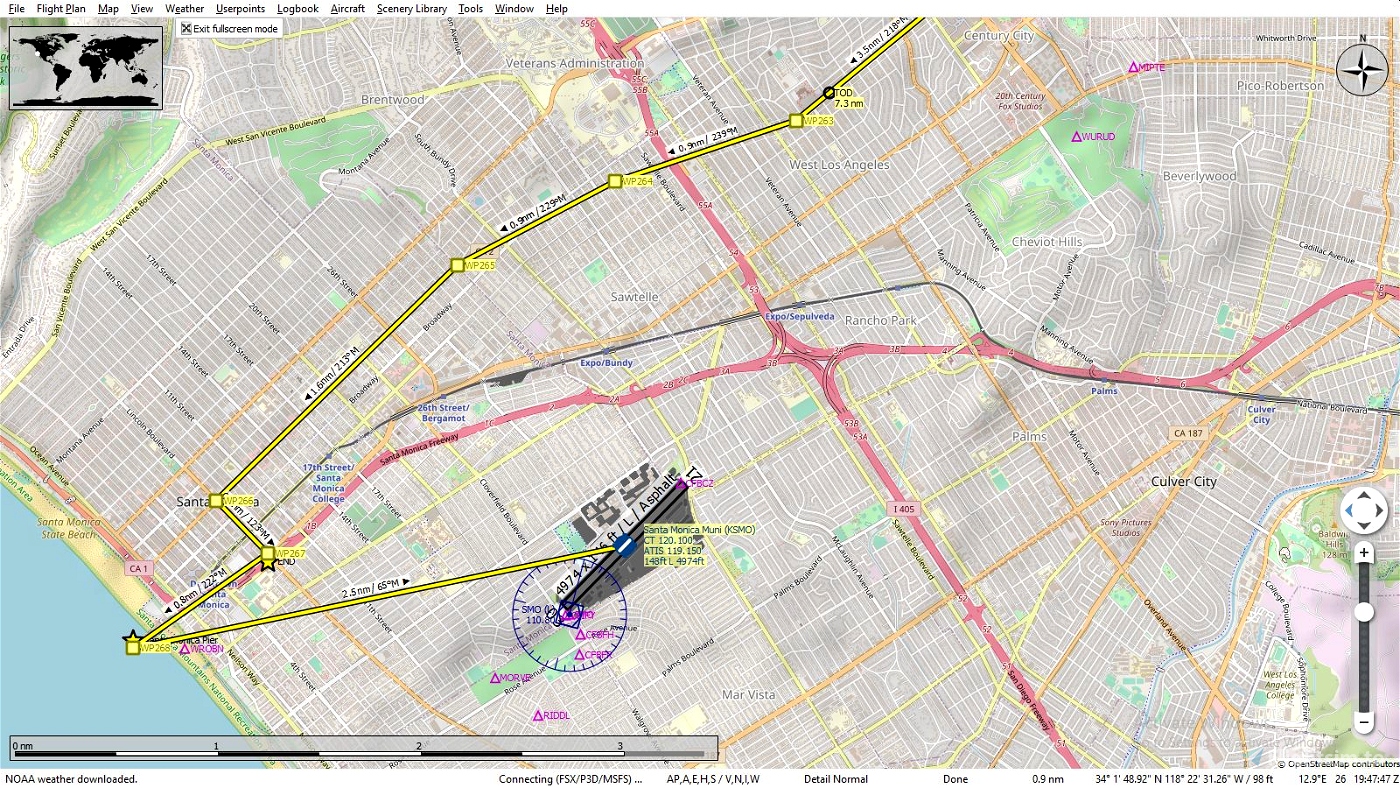
WPT260 gets us back again flying west above 66. Between WPT's 262-263 is Beverly Hills and the lifestyles of the rich and famous, swimming pools, movie stars. Continue a short ways flying over Santa Monica Boulevard to WPT266 and make a sharp turn southeast where WPT267 is the official end of Route 66 located at Lincoln & Olympic Blvds. Before landing at our final destination head over and make a pass over Santa Monica Pier, which many consider the real end of Route 66. Take a little trip down the coast or see more of the city if you wish otherwise head northwest and land at Santa Monica (KSMO).
I hope you have enjoyed your Route 66 trip and thank you for downloading and being patient on it's completion. I might consider doing others plans if I can find any good websites with detailed route information. Now all that's left is for you to take off and make the return trip...just kidding!
TIPS: It's suggested to fly low and slow since your following a route intended for automobiles. It will naturally twist and wind it's way through towns large and small so don't be to concerned about hitting each way point exactly, the idea is to follow the overall route and not take each and every turn, unless that's just your thing.
Plan on doing the entire trip through California, trust me, if you save the flight while your flying and want to resume later you can, only you won't have any way points to follow since it only loads the flight where you left off and that's it! The Illinois leg is 266 NM, 66 imagine that, and can be finished in a couple of hours depending on which aircraft you choose and how you like to fly, fast, slow, in circles etc.
Along the way you may encounter some terrain anomalies, this isn't caused by this file but the sim itself. You may wish to try and use Elevation Fixes - United States by Alpine Scenery found on this site. It corrects not only those you may see here but in your other flights as well.
INSTALATION: It's entirely up to you how you want, here are two possible ways.
Open the zip file and drag the ".pln" file into your "LocalState" folder within your MSFS2020 installation. That's where the sim keeps all your saved flights. Open MSFS2020 go to the world map, choose your aircraft and settings then load the flight plan and fly.
If you use Little Navmap, unzip the file to a temporary location then load the ".pln" file into Little Navmap and use the "Export Flight Plan as MSFS 2020 PLN" to export it into the sim, you can name this file anything you wish just so you will know exactly what file you want to load and not mix it up with another flight you may have saved. Then open MSFS2020 go to the world map, choose your aircraft and settings then load the flight plan and fly. Sounds more complicated then it really is this is the method I prefer since, as mentioned above, you can follow your flight and pause it anytime you see something interesting you want to know about such as a park, a mine etc. and hopefully it will be identified on the map. You can also edit your flight and save as it to whatever you want to call it, land at a certain airport, take a side trip to see your aunts house, it's your world have fun.
LINKS: Little Navemap
Historic Route 66 Turn by Turn - California
Marine Corps Air Ground Combat Center and Marine Air Ground Task Force Training Command
San Bernardino National Forest
Hollywood Forever & Hollywood Funeral Home
Get Your Kicks Above Route 66 Series:
#1 Illinois
#2 Missouri & Kansas
#3 Oklahoma
#4 Texas
#5 New Mexico
#7 California
STATS:
306 NM
268 waypoints
Enjoy your flight and get your kicks above Route 66!

 SearchN


change to IFR, slew, Little Navmap, then OK to leave flight and come back in the middle of flight plan, G1000 best tool
2 years ago
GeoFlyer611
Set active pause on.
2 years ago
GeoFlyer611
This is a great project. Thanks for sharing it. I have downloaded all 7 parts (along with text files for the notes you made for each flight plan) and will try it out soon, though my track record with long flights isn't very good because of all the distractions with MSFS! New planes, new airports, world updates, VR, etc. When I got my PPL in 2001 I thought that someday I might do a REAL flight across the USA but alas that ship has sailed, to mix a few metaphors.
I have two cross-country projects I plan to do "someday" that I will share since you mentioned you might do another sometime. Both are based on books. "Flight of Passage" by Rinker Buck is a wonderful story of how Rinker (15 at the time) and his older brother Kern (17) flew their family Piper Cub from NJ to Los Angeles in 1967. No radio, lots of stops at small fields, some wild characters and flight adventures. The book has enough detail to plan the flight and it's a great read. I happened to take a few lessons with Kern during my flight training.
The other one I want to do in a Stearman is The Cannibal Queen by Stephen Coonts, an ex-Navy A-6 pilot who wrote "Flight of the Intruder." He flew his Stearman to every state in two long legs from his home base in Boulder, CO. It's not as good a book as Flight of Passage but it's pretty cool.
3 years ago
Thank you for downloading and I hope you enjoy them. I think you should follow your ideas and dreams either in real life, create the flight plans or both!
You have the basic roadmaps it's just a matter of putting it together. Littlenavmap is a great tool to do that with and you can save your project and export it.
This project took a while because it follows route 66 and most of it's twists and turns so in reality not a very realistic flight and with so many historic sights and waypoints and how over the years some of the route was changed so much that even today there is debate in some areas where the original route ran. A nightmare to do and even with some of the text it never will fully encompass what I really wished to convey.
I haven't read those books, but if they are fairly detailed on the paths flown, what towns and airports, you can do it. It sounds like you have a solid foundation to work with. If you decide to create them please be sure to share. You might look into creating actual bush trips using Bush Trip Injector. I haven't tried it so can't say how well it works. It didn't seem like it would have worked so well in my case due to the file size that would have to be generated and for others to download. Perhaps I'll revisit the idea and have another look at the program. Happy flying!
3 years ago
SearchN
FlyingSinger
Have really enjoyed the trip.
3 years ago
3 years ago
SearchN
Terrylawdinn